You are here: Home > Network List > XD94 - Tanzania BB Experiment Stations List
> Station RUNG XD.RUNG > Earthquake Result Viewer
RUNG XD.RUNG - Earthquake Result Viewer
| Earthquake location: |
Samar, Philippines |
| Earthquake latitude/longitude: |
12.1/125.9 |
| Earthquake time(UTC): |
1995/04/21 (111) 05:17:00 GMT |
| Earthquake Depth: |
23 km |
| Earthquake Magnitude: |
5.6 MB, 6.9 MS, 6.7 UNKNOWN, 6.7 MW |
| Earthquake Catalog/Contributor: |
WHDF/NEIC |
|
| Network: |
XD Tanzania BB Experiment |
| Station: |
RUNG XD.RUNG |
| Lat/Lon: |
6.94 S/33.52 E |
| Elevation: |
1230 m |
|
| Distance: |
93.8 deg |
| Az: |
263.755 deg |
| Baz: |
78.29 deg |
| Ray Param: |
0.04118365 |
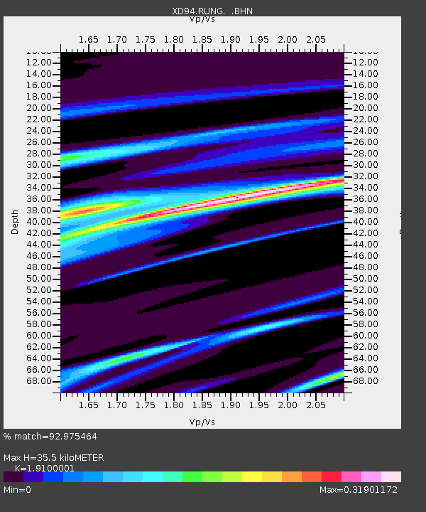
| Estimated Moho Depth: |
35.5 km |
| Estimated Crust Vp/Vs: |
1.91 |
| Assumed Crust Vp: |
6.455 km/s |
| Estimated Crust Vs: |
3.38 km/s |
| Estimated Crust Poisson's Ratio: |
0.31 |
|
| Radial Match: |
92.975464 % |
| Radial Bump: |
310 |
| Transverse Match: |
77.13586 % |
| Transverse Bump: |
400 |
| SOD ConfigId: |
6273 |
| Insert Time: |
2010-03-08 22:54:47.192 +0000 |
| GWidth: |
2.5 |
| Max Bumps: |
400 |
| Tol: |
0.001 |
|

Signal To Noise
| Channel | StoN | STA | LTA |
| XD:RUNG: :BHN:19950421T05:29:44.390027Z | 2.021064 | 91.01663 | 45.03402 |
| XD:RUNG: :BHE:19950421T05:29:44.390027Z | 1.9450049 | 93.95542 | 48.306004 |
| XD:RUNG: :BHZ:19950421T05:29:44.390027Z | 3.583556 | 377.35898 | 105.30294 |
| Arrivals |
| Ps | 5.1 SECOND |
| PpPs | 16 SECOND |
| PsPs/PpSs | 21 SECOND |


