
Station XD RUNG - XD.RUNG
Network: XD94 - Tanzania BB Experiment
Nearby stations (2 deg radius)
| Station | Name | (Lat, Lon) | Start / End | Elevation |
| RUNG | XD.RUNG | (-6.94, 33.52) | 1994-05-25 / 1995-05-17 | 1230 m |
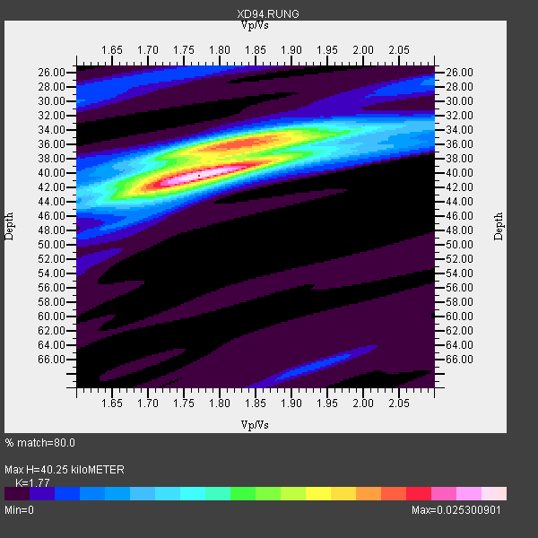
| Crust2 Type: | GE,Archean, no seds. |
| Thickness Estimate: | 40 km |
| Thickness StdDev: | 1.7 km |
| Vp/Vs Estimate: | 1.77 |
| Vp/Vs StdDev: | 0.03 |
| Vs Estimate: | 3.647 km/s |
| Poisson's Ratio: | 0.27 |
| Peak Value: | 0.03 |
| Assumed Vp: | 6.455 km/s |
| Ps Weight: | 0.33333334 |
| PpPs Weight: | 0.33333334 |
| PsPs Weight: | 0.33333328 |
| Residual Complexity: | 0.614 |
| Nearby stations H: | +- |
| (2.0 deg) Vp/Vs: | +- |
15 with match > 90% ( 41.666668 %) and 21 with match > 80% ( 58.333332 %) out of 36.
Download stack as xyz text file.
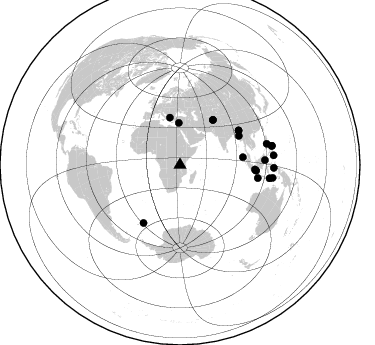
Azimuth Distribution of Events:
Prior Results for this Station
| Study | Thickness | Vp/Vs | Vp | Vs | Poissons Ratio | Extra |
| EARS | 40 km | 1.77 | 6.455 km/s | 3.647 km/s | 0.27 | |
| Crust2.0 | 42 km | 1.76 | 6.455 km/s | 3.663 km/s | 0.26 | GE,Archean, no seds. |
| Global Maxima | 40 km | 1.77 | 6.455 km/s | 3.647 km/s | 0.27 | amp=0.025300901 |
| Local Maxima 1 | 36 km | 1.80 | 6.455 km/s | 3.581 km/s | 0.28 | amp=0.016479105 |
| Local Maxima 2 | 36 km | 1.88 | 6.455 km/s | 3.425 km/s | 0.30 | amp=0.008578668 |
| Local Maxima 3 | 40 km | 1.70 | 6.455 km/s | 3.803 km/s | 0.23 | amp=0.0076904087 |
| Local Maxima 4 | 35 km | 1.83 | 6.455 km/s | 3.537 km/s | 0.29 | amp=0.005124107 |
| Predicted Arrivals for vertical incidence (zero ray parameter) | |
| Ps | 4.80 SECOND |
| PpPs | 17.27 SECOND |
| PsPs/PpSs | 22.07 SECOND |
Events Processed for this Station
Download zip of receiver functions as SAC
Plot maxima for each earthquake.
Events Used in the Stack
(21 events)| Radial Match | Distance | Baz | FERegion | Time | Lat/Lon | Depth | Magnitude |
| 98.318665 | 78.9 deg | 99.606 deg | South Of Java, Indonesia | 1994/06/04 00:57:53 GMT | (-10.8, 113.4) | 33 km | 5.8 MB, 6.2 MS, 6.0 UNKNOWN |
| 97.86889 | 76.3 deg | 94.248 deg | Java Sea | 1994/09/28 16:39:52 GMT | (-5.8, 110.3) | 643 km | 5.7 MB, 6.7 UNKNOWN, 6.6 MW |
| 97.578964 | 76.2 deg | 94.065 deg | Java Sea | 1994/11/15 20:18:11 GMT | (-5.6, 110.2) | 559 km | 6.2 MB, 6.5 UNKNOWN, 6.5 MW |
| 96.9692 | 90.5 deg | 98.468 deg | Timor Region | 1995/05/14 11:33:21 GMT | (-8.4, 125.1) | 33 km | 6.1 MB, 6.9 MS, 7.1 UNKNOWN, 6.9 MW |
| 96.95592 | 68.6 deg | 212.224 deg | South Sandwich Islands Region | 1995/03/26 02:16:16 GMT | (-55.9, -28.2) | 77 km | 6.1 MB, 5.9 MS, 6.4 UNKNOWN, 6.3 MW |
| 96.77484 | 93.5 deg | 78.405 deg | Samar, Philippines | 1995/04/21 00:09:56 GMT | (12.0, 125.7) | 33 km | 6.1 MB, 6.9 MS, 6.9 UNKNOWN, 6.8 MW |
| 96.556725 | 89.3 deg | 76.361 deg | Mindoro, Philippines | 1994/11/14 19:15:30 GMT | (13.5, 121.1) | 33 km | 6.1 MB, 7.1 MS, 7.1 UNKNOWN, 7.1 MW |
| 96.11487 | 63.4 deg | 83.125 deg | Northern Sumatra, Indonesia | 1994/10/31 11:48:15 GMT | (3.0, 96.3) | 46 km | 5.6 MB, 6.1 MS, 6.3 UNKNOWN, 6.2 MW |
| 95.66158 | 48.1 deg | 347.808 deg | Greece | 1995/05/13 08:47:12 GMT | (40.1, 21.7) | 13 km | 6.2 MB, 6.5 MS, 6.6 UNKNOWN, 6.5 MD |
| 95.26356 | 93.8 deg | 91.816 deg | Halmahera, Indonesia | 1995/02/13 15:04:26 GMT | (-1.4, 127.5) | 33 km | 6.2 MB, 6.8 MS, 6.8 UNKNOWN, 6.7 MW |
| 93.93991 | 65.5 deg | 63.827 deg | Myanmar | 1994/05/29 14:11:51 GMT | (20.5, 94.2) | 42 km | 6.2 MB, 6.2 MS, 5.9 UNKNOWN, 6.5 MW |
| 92.975464 | 93.8 deg | 78.29 deg | Samar, Philippines | 1995/04/21 05:17:00 GMT | (12.1, 125.9) | 23 km | 5.6 MB, 6.9 MS, 6.7 UNKNOWN, 6.7 MW |
| 91.7199 | 55.5 deg | 36.535 deg | Hindu Kush Region, Afghanistan | 1994/10/25 00:54:34 GMT | (36.3, 70.9) | 244 km | 5.9 MB, 6.2 UNKNOWN, 5.9 MW |
| 91.29727 | 55.6 deg | 36.359 deg | Hindu Kush Region, Afghanistan | 1995/05/16 03:35:03 GMT | (36.5, 70.9) | 190 km | 5.7 MB, 5.9 UNKNOWN, 5.8 MW |
| 90.80938 | 74.9 deg | 93.534 deg | Java Sea | 1995/05/13 21:00:54 GMT | (-5.2, 108.9) | 554 km | 5.7 MB, 5.9 UNKNOWN, 5.8 MW |
| 88.47459 | 67.8 deg | 59.881 deg | Myanmar | 1994/08/08 21:08:31 GMT | (24.7, 95.2) | 127 km | 6.0 MB, 5.1 UNKNOWN, 6.1 MW |
| 87.426445 | 85.1 deg | 86.728 deg | Celebes Sea | 1995/03/06 18:43:42 GMT | (2.7, 118.2) | 33 km | 5.5 MB, 5.8 MS, 6.3 UNKNOWN, 6.1 MW |
| 87.205635 | 94.0 deg | 84.181 deg | Mindanao, Philippines | 1995/04/20 08:45:10 GMT | (6.3, 126.8) | 85 km | 6.2 MB, 6.6 UNKNOWN, 6.5 MW |
| 84.3839 | 41.8 deg | 358.458 deg | Cyprus Region | 1995/02/23 21:03:02 GMT | (35.0, 32.3) | 15 km | 5.8 MB, 5.7 MS, 5.9 UNKNOWN, 5.8 MW |
| 83.860664 | 93.4 deg | 97.935 deg | Banda Sea | 1994/07/13 11:45:25 GMT | (-7.5, 127.9) | 185 km | 6.4 MB, 6.8 UNKNOWN, 6.5 MW |
| 83.45567 | 68.0 deg | 59.624 deg | Myanmar-India Border Region | 1995/05/06 01:59:07 GMT | (25.0, 95.3) | 122 km | 6.4 MB, 6.5 UNKNOWN, 6.4 MW |
Losers
(15 events)| Radial Match | Distance | Baz | FERegion | Time | Lat/Lon | Depth | Magnitude | Reason |
| 78.09252 | 94.1 deg | 84.331 deg | Mindanao, Philippines | 1995/04/04 17:21:04 GMT | (6.2, 127.0) | 86 km | 5.5 MB | |
| 76.03968 | 93.7 deg | 78.855 deg | Samar, Philippines | 1995/05/08 18:08:09 GMT | (11.6, 125.9) | 33 km | 5.6 MB, 6.2 MS, 6.3 UNKNOWN, 6.3 MW | |
| 71.49451 | 55.0 deg | 322.476 deg | Strait Of Gibraltar | 1994/05/26 08:26:52 GMT | (35.4, -4.1) | 10 km | 5.7 MB, 5.8 MS, 5.9 UNKNOWN | |
| 69.92956 | 94.9 deg | 286.018 deg | Leeward Islands | 1995/03/08 03:45:59 GMT | (16.6, -59.6) | 15 km | 6.3 MB, 6.2 MS, 6.4 UNKNOWN, 6.1 MD | |
| 68.87188 | 93.7 deg | 97.839 deg | Banda Sea | 1994/06/16 10:12:48 GMT | (-7.4, 128.1) | 119 km | 5.8 MB, 6.0 UNKNOWN, 5.9 MW | |
| 66.85064 | 93.7 deg | 91.839 deg | Halmahera, Indonesia | 1995/02/13 12:29:55 GMT | (-1.4, 127.4) | 33 km | 5.8 MB, 6.0 MS, 6.1 UNKNOWN, 5.9 MW | |
| 66.202576 | 93.9 deg | 78.673 deg | Philippine Islands Region | 1995/04/29 09:44:00 GMT | (11.8, 126.0) | 33 km | 5.4 MB, 6.0 MS, 6.1 UNKNOWN, 6.0 MW | |
| 65.41012 | 95.2 deg | 88.759 deg | Halmahera, Indonesia | 1995/05/04 02:18:51 GMT | (1.9, 128.5) | 55 km | 6.0 MB, 6.0 MS, 6.1 UNKNOWN, 6.1 MW | |
| 65.369194 | 93.8 deg | 97.831 deg | Banda Sea | 1995/01/19 09:55:34 GMT | (-7.3, 128.3) | 170 km | 5.8 MB, 6.1 UNKNOWN, 5.9 MW | |
| 61.391388 | 92.6 deg | 33.372 deg | East Of Lake Baykal, Russia | 1994/08/21 15:56:01 GMT | (56.7, 117.8) | 33 km | 5.7 MB, 5.8 MS, 6.0 UNKNOWN, 6.0 MW | |
| 58.11514 | 79.2 deg | 306.197 deg | Northern Mid-Atlantic Ridge | 1995/04/17 07:14:35 GMT | (33.8, -38.6) | 10 km | 5.8 MB, 5.8 MS, 5.9 UNKNOWN, 6.1 MW | |
| 55.958164 | 93.3 deg | 85.183 deg | Mindanao, Philippines | 1995/02/19 00:17:48 GMT | (5.2, 126.2) | 104 km | 5.9 MB, 6.1 UNKNOWN, 6.1 MW | |
| 55.141273 | 69.4 deg | 51.565 deg | Xizang | 1994/06/29 18:22:36 GMT | (32.5, 93.7) | 33 km | 5.8 MB, 5.5 MS, 5.3 UNKNOWN, 5.7 MW | |
| 50.29423 | 93.7 deg | 81.26 deg | Mindanao, Philippines | 1995/01/06 21:59:32 GMT | (9.2, 126.2) | 61 km | 5.7 MB, 5.9 UNKNOWN, 5.7 MW | |
| 43.85346 | 91.5 deg | 94.794 deg | Banda Sea | 1994/07/16 18:05:07 GMT | (-4.6, 125.6) | 461 km | 5.8 MB |
