Y15 Y15 - Earthquake Result Viewer
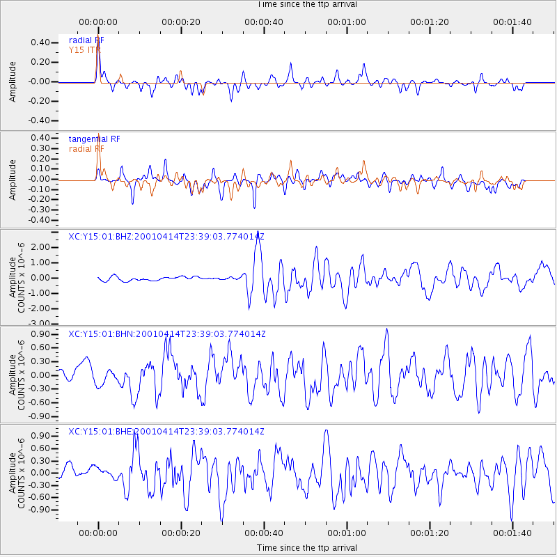
Earthquake location: Southeast Of Honshu, Japan
Earthquake latitude/longitude: 30.1/141.8
Earthquake time(UTC): 2001/04/14 (104) 23:27:26 GMT
Earthquake Depth: 10 km
Earthquake Magnitude: 6.0 MB, 5.8 MS, 6.0 MW, 6.0 ME
Earthquake Catalog/Contributor: WHDF/NEIC
Network: XC Yellowstone Intermountain Seismic Array
Station: Y15 Y15
Lat/Lon: 44.58 N/112.06 W
Elevation: 2100 m
Distance: 79.8 deg
Az: 44.21 deg
Baz: 302.255 deg
Ray Param: 0.04869025
Estimated Moho Depth: 53.25 km
Estimated Crust Vp/Vs: 1.60
Assumed Crust Vp: 6.577 km/s
Estimated Crust Vs: 4.111 km/s
Estimated Crust Poisson's Ratio: 0.18
Radial Match: 81.621445 %
Radial Bump: 400
Transverse Match: 71.86113 %
Transverse Bump: 400
SOD ConfigId: 16820
Insert Time: 2010-02-26 14:58:04.410 +0000
GWidth: 2.5
Max Bumps: 400
Tol: 0.001

Signal To Noise

ChannelStoNSTALTA
XC:Y15:01:BHN:20010414T23:39:03.774014Z1.21801341.5575021E-71.2787233E-7
XC:Y15:01:BHE:20010414T23:39:03.774014Z0.96533111.356258E-71.4049667E-7
XC:Y15:01:BHZ:20010414T23:39:03.774014Z0.57668667.5350066E-81.3066034E-7
Arrivals
Ps5.0 SECOND
PpPs20 SECOND
PsPs/PpSs25 SECOND