
Station XC Y15 - Y15
Network: XC00 - Yellowstone Intermountain Seismic Array
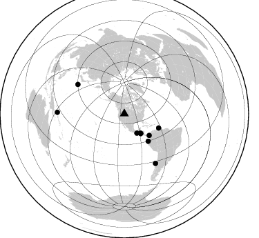
Nearby stations (2 deg radius)
| Station | Name | (Lat, Lon) | Start / End | Elevation |
| Y15 | Y15 | (44.58, -112.06) | 2000-07-14 / 2001-12-31 | 2100 m |
| Crust2 Type: | H3,early/mid Proter. shield, Finland, 0.5 km seds. |
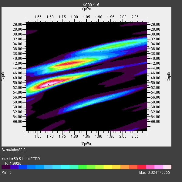
| Thickness Estimate: | 50 km |
| Thickness StdDev: | 5.9 km |
| Vp/Vs Estimate: | 1.69 |
| Vp/Vs StdDev: | 0.08 |
| Vs Estimate: | 3.886 km/s |
| Poisson's Ratio: | 0.23 |
| Peak Value: | 0.02 |
| Assumed Vp: | 6.577 km/s |
| Ps Weight: | 0.33333334 |
| PpPs Weight: | 0.33333334 |
| PsPs Weight: | 0.33333328 |
| Residual Complexity: | 0.761 |
| Nearby stations H: | +- |
| (2.0 deg) Vp/Vs: | +- |
5 with match > 90% ( 55.555557 %) and 9 with match > 80% ( 100.0 %) out of 9.
Download stack as xyz text file.
Azimuth Distribution of Events:
Prior Results for this Station
| Study | Thickness | Vp/Vs | Vp | Vs | Poissons Ratio | Extra |
| EARS | 50 km | 1.69 | 6.577 km/s | 3.886 km/s | 0.23 | |
| Crust2.0 | 46 km | 1.78 | 6.577 km/s | 3.701 km/s | 0.27 | H3,early/mid Proter. shield, Finland, 0.5 km seds. |
| Global Maxima | 50 km | 1.69 | 6.577 km/s | 3.886 km/s | 0.23 | amp=0.024776055 |
| Local Maxima 1 | 42 km | 1.77 | 6.577 km/s | 3.716 km/s | 0.27 | amp=0.020856787 |
| Local Maxima 2 | 48 km | 1.72 | 6.577 km/s | 3.824 km/s | 0.24 | amp=0.012290811 |
| Local Maxima 3 | 34 km | 2.01 | 6.577 km/s | 3.272 km/s | 0.34 | amp=0.011696595 |
| Local Maxima 4 | 59 km | 1.85 | 6.577 km/s | 3.565 km/s | 0.29 | amp=0.011673334 |
| Predicted Arrivals for vertical incidence (zero ray parameter) | |
| Ps | 5.32 SECOND |
| PpPs | 20.67 SECOND |
| PsPs/PpSs | 25.99 SECOND |
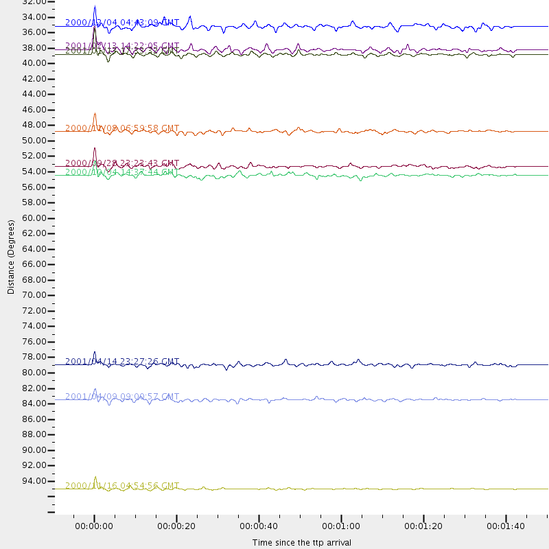
Events Processed for this Station
Download zip of receiver functions as SAC
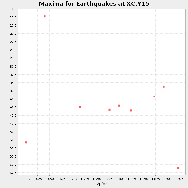
Plot maxima for each earthquake.
Events Used in the Stack
(9 events)| Radial Match | Distance | Baz | FERegion | Time | Lat/Lon | Depth | Magnitude |
| 92.320175 | 37.2 deg | 140.242 deg | El Salvador | 2001/01/13 17:33:32 GMT | (13.0, -88.7) | 60 km | 6.4 MB, 7.8 MS, 7.7 MW, 7.5 ME |
| 91.204056 | 53.9 deg | 112.48 deg | Windward Islands | 2000/10/04 14:37:44 GMT | (11.1, -62.6) | 110 km | 5.6 MB, 5.4 MS, 6.1 MW, 5.9 MD |
| 90.96267 | 36.6 deg | 140.156 deg | El Salvador | 2001/02/13 14:22:05 GMT | (13.7, -88.9) | 10 km | 5.5 MB, 6.5 MS, 6.6 MW, 6.1 MD |
| 90.72423 | 52.6 deg | 138.927 deg | Near Coast Of Ecuador | 2000/09/28 23:23:43 GMT | (-0.2, -80.6) | 23 km | 5.8 MB, 6.0 MS, 6.6 MW, 6.4 MW |
| 90.6027 | 84.7 deg | 147.819 deg | Off Coast Of Central Chile | 2001/04/09 09:00:57 GMT | (-32.7, -73.1) | 11 km | 6.1 MB, 6.3 MS, 6.7 MW, 6.3 ME |
| 87.43753 | 96.9 deg | 271.204 deg | New Ireland Region, P.N.G. | 2000/11/16 04:54:56 GMT | (-4.0, 152.2) | 33 km | 6.0 MB, 8.2 MS, 8.0 MW, 8.0 ME |
| 82.29959 | 47.8 deg | 131.092 deg | Panama-Colombia Border Region | 2000/11/08 06:59:58 GMT | (7.0, -77.8) | 17 km | 6.0 MB, 6.4 MS, 6.5 MW, 6.2 ML |
| 81.621445 | 79.8 deg | 302.255 deg | Southeast Of Honshu, Japan | 2001/04/14 23:27:26 GMT | (30.1, 141.8) | 10 km | 6.0 MB, 5.8 MS, 6.0 MW, 6.0 ME |
| 80.27174 | 33.4 deg | 146.856 deg | Near Coast Of Chiapas, Mexico | 2000/12/04 04:43:09 GMT | (14.9, -93.9) | 33 km | 5.6 MB, 5.7 MS, 6.0 MW, 5.9 MW |
Losers
(0 events)| Radial Match | Distance | Baz | FERegion | Time | Lat/Lon | Depth | Magnitude | Reason |
