You are here: Home > Network List > XD94 - Tanzania BB Experiment Stations List
> Station TUND XD.TUND > Earthquake Result Viewer
TUND XD.TUND - Earthquake Result Viewer
| Earthquake location: |
Banda Sea |
| Earthquake latitude/longitude: |
-7.5/127.9 |
| Earthquake time(UTC): |
1994/07/13 (194) 11:45:25 GMT |
| Earthquake Depth: |
185 km |
| Earthquake Magnitude: |
6.4 MB, 6.8 UNKNOWN, 6.5 MW |
| Earthquake Catalog/Contributor: |
WHDF/NEIC |
|
| Network: |
XD Tanzania BB Experiment |
| Station: |
TUND XD.TUND |
| Lat/Lon: |
9.30 S/32.77 E |
| Elevation: |
1660 m |
|
| Distance: |
93.8 deg |
| Az: |
260.154 deg |
| Baz: |
98.194 deg |
| Ray Param: |
0.04105257 |
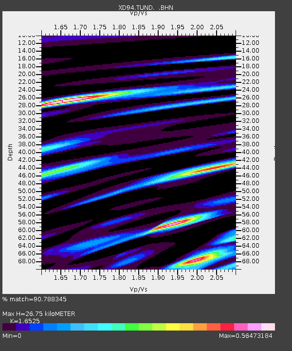
| Estimated Moho Depth: |
26.75 km |
| Estimated Crust Vp/Vs: |
1.65 |
| Assumed Crust Vp: |
6.502 km/s |
| Estimated Crust Vs: |
3.934 km/s |
| Estimated Crust Poisson's Ratio: |
0.21 |
|
| Radial Match: |
90.788345 % |
| Radial Bump: |
400 |
| Transverse Match: |
79.78157 % |
| Transverse Bump: |
400 |
| SOD ConfigId: |
16938 |
| Insert Time: |
2010-03-08 22:56:07.249 +0000 |
| GWidth: |
2.5 |
| Max Bumps: |
400 |
| Tol: |
0.001 |
|

Signal To Noise
| Channel | StoN | STA | LTA |
| XD:TUND: :BHN:19940713T11:57:50.743994Z | 1.8756678 | 170.67456 | 90.994026 |
| XD:TUND: :BHE:19940713T11:57:50.743994Z | 4.5916457 | 282.50388 | 61.525627 |
| XD:TUND: :BHZ:19940713T11:57:50.743994Z | 5.2107215 | 817.17224 | 156.82516 |
| Arrivals |
| Ps | 2.7 SECOND |
| PpPs | 11 SECOND |
| PsPs/PpSs | 13 SECOND |


