
Station XD TUND - XD.TUND
Network: XD94 - Tanzania BB Experiment
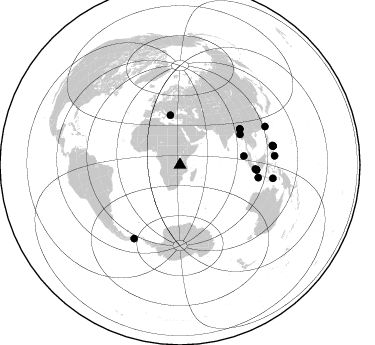
Nearby stations (2 deg radius)

| Station | Name | (Lat, Lon) | Start / End | Elevation |
| TUND | XD.TUND | (-9.30, 32.77) | 1994-05-27 / 1995-05-15 | 1660 m |
| Crust2 Type: | X2,Rift, Rio Grande, Baikal, 0.5km sediments |
| Thickness Estimate: | 25 km |
| Thickness StdDev: | 9.4 km |
| Vp/Vs Estimate: | 1.75 |
| Vp/Vs StdDev: | 0.06 |
| Vs Estimate: | 3.72 km/s |
| Poisson's Ratio: | 0.26 |
| Peak Value: | 0.01 |
| Assumed Vp: | 6.502 km/s |
| Ps Weight: | 0.33333334 |
| PpPs Weight: | 0.33333334 |
| PsPs Weight: | 0.33333328 |
| Residual Complexity: | 0.762 |
| Nearby stations H: | +- |
| (2.0 deg) Vp/Vs: | +- |
12 with match > 90% ( 52.173912 %) and 16 with match > 80% ( 69.565216 %) out of 23.
Download stack as xyz text file.
Azimuth Distribution of Events:
Prior Results for this Station
| Study | Thickness | Vp/Vs | Vp | Vs | Poissons Ratio | Extra |
| EARS | 25 km | 1.75 | 6.502 km/s | 3.72 km/s | 0.26 | |
| Crust2.0 | 33 km | 1.77 | 6.502 km/s | 3.68 km/s | 0.26 | X2,Rift, Rio Grande, Baikal, 0.5km sediments |
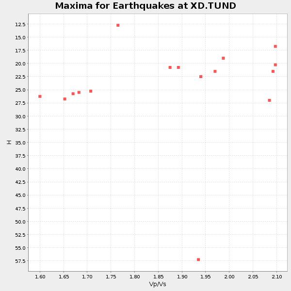
| Global Maxima | 25 km | 1.75 | 6.502 km/s | 3.72 km/s | 0.26 | amp=0.010051791 |
| Local Maxima 1 | 44 km | 1.65 | 6.502 km/s | 3.94 km/s | 0.21 | amp=0.005033277 |
| Local Maxima 2 | 30 km | 1.80 | 6.502 km/s | 3.607 km/s | 0.28 | amp=0.0046097846 |
| Local Maxima 3 | 68 km | 2.01 | 6.502 km/s | 3.235 km/s | 0.34 | amp=0.0040603145 |
| Local Maxima 4 | 44 km | 1.72 | 6.502 km/s | 3.791 km/s | 0.24 | amp=0.0037516444 |
| Predicted Arrivals for vertical incidence (zero ray parameter) | |
| Ps | 2.87 SECOND |
| PpPs | 10.56 SECOND |
| PsPs/PpSs | 13.44 SECOND |
Events Processed for this Station
Download zip of receiver functions as SAC
Plot maxima for each earthquake.
Events Used in the Stack
(16 events)| Radial Match | Distance | Baz | FERegion | Time | Lat/Lon | Depth | Magnitude |
| 98.44903 | 79.2 deg | 99.239 deg | South Of Java, Indonesia | 1994/06/04 00:57:53 GMT | (-10.8, 113.4) | 33 km | 5.8 MB, 6.2 MS, 6.0 UNKNOWN |
| 97.97397 | 50.2 deg | 348.946 deg | Greece | 1995/05/13 08:47:12 GMT | (40.1, 21.7) | 13 km | 6.2 MB, 6.5 MS, 6.6 UNKNOWN, 6.5 MD |
| 96.514946 | 67.2 deg | 63.159 deg | Myanmar | 1994/05/29 14:11:51 GMT | (20.5, 94.2) | 42 km | 6.2 MB, 6.2 MS, 5.9 UNKNOWN, 6.5 MW |
| 96.35348 | 76.7 deg | 93.594 deg | Java Sea | 1994/11/15 20:18:11 GMT | (-5.6, 110.2) | 559 km | 6.2 MB, 6.5 UNKNOWN, 6.5 MW |
| 96.31149 | 64.4 deg | 82.139 deg | Northern Sumatra, Indonesia | 1994/10/31 11:48:15 GMT | (3.0, 96.3) | 46 km | 5.6 MB, 6.1 MS, 6.3 UNKNOWN, 6.2 MW |
| 95.673065 | 69.8 deg | 59.095 deg | Myanmar-India Border Region | 1995/05/06 01:59:07 GMT | (25.0, 95.3) | 122 km | 6.4 MB, 6.5 UNKNOWN, 6.4 MW |
| 95.225174 | 94.7 deg | 78.666 deg | Samar, Philippines | 1995/04/21 00:09:56 GMT | (12.0, 125.7) | 33 km | 6.1 MB, 6.9 MS, 6.9 UNKNOWN, 6.8 MW |
| 93.23648 | 69.6 deg | 59.343 deg | Myanmar | 1994/08/08 21:08:31 GMT | (24.7, 95.2) | 127 km | 6.0 MB, 5.1 UNKNOWN, 6.1 MW |
| 92.12119 | 76.8 deg | 93.782 deg | Java Sea | 1994/09/28 16:39:52 GMT | (-5.8, 110.3) | 643 km | 5.7 MB, 6.7 UNKNOWN, 6.6 MW |
| 91.88659 | 75.5 deg | 93.01 deg | Java Sea | 1995/05/13 21:00:54 GMT | (-5.2, 108.9) | 554 km | 5.7 MB, 5.9 UNKNOWN, 5.8 MW |
| 91.81187 | 94.5 deg | 78.244 deg | Samar, Philippines | 1995/04/23 05:08:03 GMT | (12.4, 125.4) | 33 km | 6.0 MB, 6.6 MS, 6.7 UNKNOWN, 6.7 MW |
| 90.788345 | 93.8 deg | 98.194 deg | Banda Sea | 1994/07/13 11:45:25 GMT | (-7.5, 127.9) | 185 km | 6.4 MB, 6.8 UNKNOWN, 6.5 MW |
| 85.063515 | 95.0 deg | 84.464 deg | Mindanao, Philippines | 1995/04/20 08:45:10 GMT | (6.3, 126.8) | 85 km | 6.2 MB, 6.6 UNKNOWN, 6.5 MW |
| 83.806435 | 95.0 deg | 78.56 deg | Samar, Philippines | 1995/04/21 05:17:00 GMT | (12.1, 125.9) | 23 km | 5.6 MB, 6.9 MS, 6.7 UNKNOWN, 6.7 MW |
| 80.81977 | 93.1 deg | 65.852 deg | Taiwan Region | 1994/06/05 01:09:31 GMT | (24.5, 122.0) | 16 km | 6.0 MB, 6.5 MS, 6.1 UNKNOWN, 6.4 MW |
| 80.308105 | 86.9 deg | 212.109 deg | Drake Passage | 1995/01/03 16:11:59 GMT | (-57.7, -66.0) | 33 km | 6.1 MB, 5.6 MS, 6.1 UNKNOWN, 5.9 MW |
Losers
(7 events)| Radial Match | Distance | Baz | FERegion | Time | Lat/Lon | Depth | Magnitude | Reason |
| 73.89716 | 80.0 deg | 306.729 deg | Northern Mid-Atlantic Ridge | 1995/04/17 07:14:35 GMT | (33.8, -38.6) | 10 km | 5.8 MB, 5.8 MS, 5.9 UNKNOWN, 6.1 MW | |
| 73.28978 | 68.1 deg | 137.292 deg | Southeast Indian Ridge | 1994/07/28 08:03:02 GMT | (-47.3, 100.4) | 10 km | 5.7 MS, 5.2 MB, 6.1 UNKNOWN | |
| 64.80232 | 90.2 deg | 97.065 deg | Banda Sea | 1994/08/30 19:42:48 GMT | (-7.0, 124.2) | 618 km | 5.8 MB, 6.4 UNKNOWN, 6.2 MW | |
| 61.178364 | 94.9 deg | 79.121 deg | Samar, Philippines | 1995/05/08 18:08:09 GMT | (11.6, 125.9) | 33 km | 5.6 MB, 6.2 MS, 6.3 UNKNOWN, 6.3 MW | |
| 59.354465 | 95.9 deg | 89.09 deg | Halmahera, Indonesia | 1995/05/04 02:18:51 GMT | (1.9, 128.5) | 55 km | 6.0 MB, 6.0 MS, 6.1 UNKNOWN, 6.1 MW | |
| 58.45959 | 96.9 deg | 235.967 deg | Near Coast Of Central Chile | 1994/10/11 01:37:20 GMT | (-32.1, -71.4) | 51 km | 5.6 MB, 5.3 MS, 5.8 UNKNOWN, 5.4 MD | |
| 50.470173 | 95.1 deg | 84.618 deg | Mindanao, Philippines | 1995/04/04 17:21:04 GMT | (6.2, 127.0) | 86 km | 5.5 MB |
