You are here: Home > Network List > XD94 - Tanzania BB Experiment Stations List
> Station TUND XD.TUND > Earthquake Result Viewer
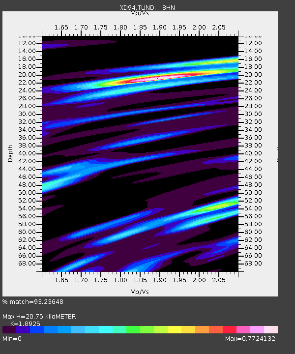
TUND XD.TUND - Earthquake Result Viewer
| Earthquake location: |
Myanmar |
| Earthquake latitude/longitude: |
24.7/95.2 |
| Earthquake time(UTC): |
1994/08/08 (220) 21:08:31 GMT |
| Earthquake Depth: |
127 km |
| Earthquake Magnitude: |
6.0 MB, 5.1 UNKNOWN, 6.1 MW |
| Earthquake Catalog/Contributor: |
WHDF/NEIC |
|
| Network: |
XD Tanzania BB Experiment |
| Station: |
TUND XD.TUND |
| Lat/Lon: |
9.30 S/32.77 E |
| Elevation: |
1660 m |
|
| Distance: |
69.6 deg |
| Az: |
249.009 deg |
| Baz: |
59.343 deg |
| Ray Param: |
0.05519867 |
| Estimated Moho Depth: |
20.75 km |
| Estimated Crust Vp/Vs: |
1.89 |
| Assumed Crust Vp: |
6.502 km/s |
| Estimated Crust Vs: |
3.435 km/s |
| Estimated Crust Poisson's Ratio: |
0.31 |
|
| Radial Match: |
93.23648 % |
| Radial Bump: |
298 |
| Transverse Match: |
82.05652 % |
| Transverse Bump: |
400 |
| SOD ConfigId: |
16938 |
| Insert Time: |
2010-03-08 22:56:08.081 +0000 |
| GWidth: |
2.5 |
| Max Bumps: |
400 |
| Tol: |
0.001 |
|

Signal To Noise
| Channel | StoN | STA | LTA |
| XD:TUND: :BHN:19940808T21:18:56.491003Z | 1.5328312 | 123.38791 | 80.496735 |
| XD:TUND: :BHE:19940808T21:18:56.491003Z | 2.6495392 | 224.22868 | 84.62931 |
| XD:TUND: :BHZ:19940808T21:18:56.491003Z | 5.2759113 | 636.91815 | 120.721924 |
| Arrivals |
| Ps | 3.0 SECOND |
| PpPs | 8.9 SECOND |
| PsPs/PpSs | 12 SECOND |


