You are here: Home > Network List > XD94 - Tanzania BB Experiment Stations List
> Station TUND XD.TUND > Earthquake Result Viewer
TUND XD.TUND - Earthquake Result Viewer
| Earthquake location: |
Samar, Philippines |
| Earthquake latitude/longitude: |
12.0/125.7 |
| Earthquake time(UTC): |
1995/04/21 (111) 00:09:56 GMT |
| Earthquake Depth: |
33 km |
| Earthquake Magnitude: |
6.1 MB, 6.9 MS, 6.9 UNKNOWN, 6.8 MW |
| Earthquake Catalog/Contributor: |
WHDF/NEIC |
|
| Network: |
XD Tanzania BB Experiment |
| Station: |
TUND XD.TUND |
| Lat/Lon: |
9.30 S/32.77 E |
| Elevation: |
1660 m |
|
| Distance: |
94.7 deg |
| Az: |
261.541 deg |
| Baz: |
78.666 deg |
| Ray Param: |
0.04095559 |
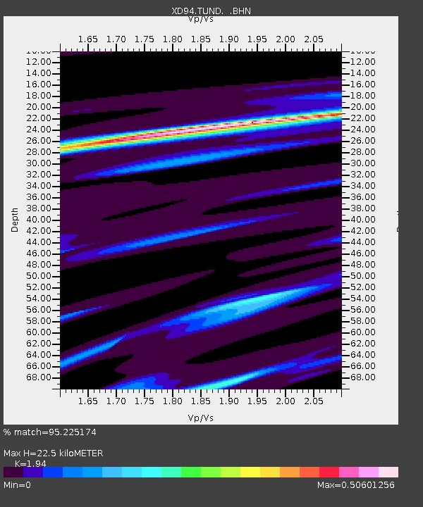
| Estimated Moho Depth: |
22.5 km |
| Estimated Crust Vp/Vs: |
1.94 |
| Assumed Crust Vp: |
6.502 km/s |
| Estimated Crust Vs: |
3.351 km/s |
| Estimated Crust Poisson's Ratio: |
0.32 |
|
| Radial Match: |
95.225174 % |
| Radial Bump: |
204 |
| Transverse Match: |
74.30186 % |
| Transverse Bump: |
400 |
| SOD ConfigId: |
6273 |
| Insert Time: |
2010-03-08 22:56:13.747 +0000 |
| GWidth: |
2.5 |
| Max Bumps: |
400 |
| Tol: |
0.001 |
|

Signal To Noise
| Channel | StoN | STA | LTA |
| XD:TUND: :BHN:19950421T00:22:42.811023Z | 0.37893257 | 27.629875 | 72.915016 |
| XD:TUND: :BHE:19950421T00:22:42.811023Z | 2.6023176 | 207.01572 | 79.55052 |
| XD:TUND: :BHZ:19950421T00:22:42.811023Z | 6.636466 | 566.1685 | 85.311745 |
| Arrivals |
| Ps | 3.3 SECOND |
| PpPs | 10.0 SECOND |
| PsPs/PpSs | 13 SECOND |


