You are here: Home > Network List > XD94 - Tanzania BB Experiment Stations List
> Station TUND XD.TUND > Earthquake Result Viewer
TUND XD.TUND - Earthquake Result Viewer
| Earthquake location: |
Samar, Philippines |
| Earthquake latitude/longitude: |
12.1/125.9 |
| Earthquake time(UTC): |
1995/04/21 (111) 05:17:00 GMT |
| Earthquake Depth: |
23 km |
| Earthquake Magnitude: |
5.6 MB, 6.9 MS, 6.7 UNKNOWN, 6.7 MW |
| Earthquake Catalog/Contributor: |
WHDF/NEIC |
|
| Network: |
XD Tanzania BB Experiment |
| Station: |
TUND XD.TUND |
| Lat/Lon: |
9.30 S/32.77 E |
| Elevation: |
1660 m |
|
| Distance: |
95.0 deg |
| Az: |
261.602 deg |
| Baz: |
78.56 deg |
| Ray Param: |
0.040892743 |
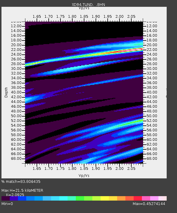
| Estimated Moho Depth: |
21.5 km |
| Estimated Crust Vp/Vs: |
2.09 |
| Assumed Crust Vp: |
6.502 km/s |
| Estimated Crust Vs: |
3.107 km/s |
| Estimated Crust Poisson's Ratio: |
0.35 |
|
| Radial Match: |
83.806435 % |
| Radial Bump: |
400 |
| Transverse Match: |
72.774086 % |
| Transverse Bump: |
400 |
| SOD ConfigId: |
6273 |
| Insert Time: |
2010-03-08 22:56:14.505 +0000 |
| GWidth: |
2.5 |
| Max Bumps: |
400 |
| Tol: |
0.001 |
|

Signal To Noise
| Channel | StoN | STA | LTA |
| XD:TUND: :BHN:19950421T05:29:49.81001Z | 0.7648851 | 72.19459 | 94.38618 |
| XD:TUND: :BHE:19950421T05:29:49.81001Z | 1.1129576 | 104.75985 | 94.12744 |
| XD:TUND: :BHZ:19950421T05:29:49.81001Z | 3.1801732 | 222.72864 | 70.03664 |
| Arrivals |
| Ps | 3.7 SECOND |
| PpPs | 10 SECOND |
| PsPs/PpSs | 14 SECOND |


