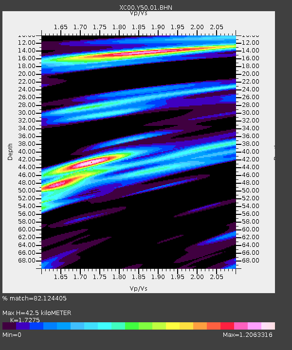
Y50 Y50 - Earthquake Result Viewer
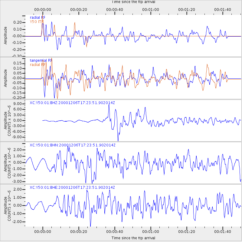
Earthquake location: Turkmenistan
Earthquake latitude/longitude: 39.6/54.8
Earthquake time(UTC): 2000/12/06 (341) 17:11:06 GMT
Earthquake Depth: 30 km
Earthquake Magnitude: 6.7 MB, 7.5 MS, 7.0 MW, 6.9 ME
Earthquake Catalog/Contributor: WHDF/NEIC
Network: XC Yellowstone Intermountain Seismic Array
Station: Y50 Y50
Lat/Lon: 45.15 N/108.97 W
Elevation: 1197 m
Distance: 94.4 deg
Az: 348.556 deg
Baz: 12.518 deg
Ray Param: 0.041039478
Estimated Moho Depth: 42.5 km
Estimated Crust Vp/Vs: 1.73
Assumed Crust Vp: 6.242 km/s
Estimated Crust Vs: 3.613 km/s
Estimated Crust Poisson's Ratio: 0.25
Radial Match: 82.124405 %
Radial Bump: 400
Transverse Match: 74.86811 %
Transverse Bump: 400
SOD ConfigId: 16820
Insert Time: 2010-02-26 14:58:09.170 +0000
GWidth: 2.5
Max Bumps: 400
Tol: 0.001

Signal To Noise

ChannelStoNSTALTA
XC:Y50:01:BHN:20001206T17:23:51.902014Z1.68275968.0447205E-74.780671E-7
XC:Y50:01:BHE:20001206T17:23:51.902014Z1.09419793.9503044E-73.6102287E-7
XC:Y50:01:BHZ:20001206T17:23:51.902014Z1.88756175.20074E-72.755269E-7
Arrivals
Ps5.1 SECOND
PpPs18 SECOND
PsPs/PpSs23 SECOND