
Station XC Y50 - Y50
Network: XC00 - Yellowstone Intermountain Seismic Array
Nearby stations (2 deg radius)
| Station | Name | (Lat, Lon) | Start / End | Elevation |
| Y50 | Y50 | (45.15, -108.97) | 2000-06-21 / 2001-12-31 | 1197 m |
| Crust2 Type: | PD,orogen/50km, Tibet, 2 km seds. |
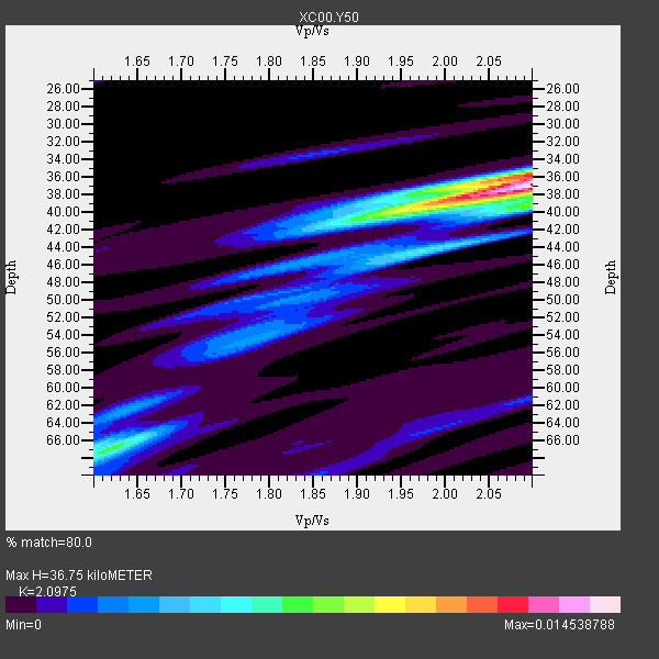
| Thickness Estimate: | 37 km |
| Thickness StdDev: | 12 km |
| Vp/Vs Estimate: | 2.10 |
| Vp/Vs StdDev: | 0.19 |
| Vs Estimate: | 2.976 km/s |
| Poisson's Ratio: | 0.35 |
| Peak Value: | 0.01 |
| Assumed Vp: | 6.242 km/s |
| Ps Weight: | 0.33333334 |
| PpPs Weight: | 0.33333334 |
| PsPs Weight: | 0.33333328 |
| Residual Complexity: | 0.557 |
| Nearby stations H: | +- |
| (2.0 deg) Vp/Vs: | +- |
2 with match > 90% ( 18.181818 %) and 11 with match > 80% ( 100.0 %) out of 11.
Download stack as xyz text file.
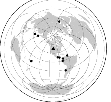
Azimuth Distribution of Events:
Prior Results for this Station
| Study | Thickness | Vp/Vs | Vp | Vs | Poissons Ratio | Extra |
| EARS | 37 km | 2.10 | 6.242 km/s | 2.976 km/s | 0.35 | |
| Crust2.0 | 50 km | 1.76 | 6.242 km/s | 3.546 km/s | 0.26 | PD,orogen/50km, Tibet, 2 km seds. |
| Global Maxima | 37 km | 2.10 | 6.242 km/s | 2.976 km/s | 0.35 | amp=0.014538788 |
| Local Maxima 1 | 36 km | 2.10 | 6.242 km/s | 2.976 km/s | 0.35 | amp=0.008091675 |
| Local Maxima 2 | 66 km | 1.63 | 6.242 km/s | 3.835 km/s | 0.20 | amp=0.0060282107 |
| Local Maxima 3 | 40 km | 1.92 | 6.242 km/s | 3.247 km/s | 0.31 | amp=0.0056809816 |
| Local Maxima 4 | 39 km | 2.10 | 6.242 km/s | 2.976 km/s | 0.35 | amp=0.0046333773 |
| Predicted Arrivals for vertical incidence (zero ray parameter) | |
| Ps | 6.46 SECOND |
| PpPs | 18.24 SECOND |
| PsPs/PpSs | 24.70 SECOND |
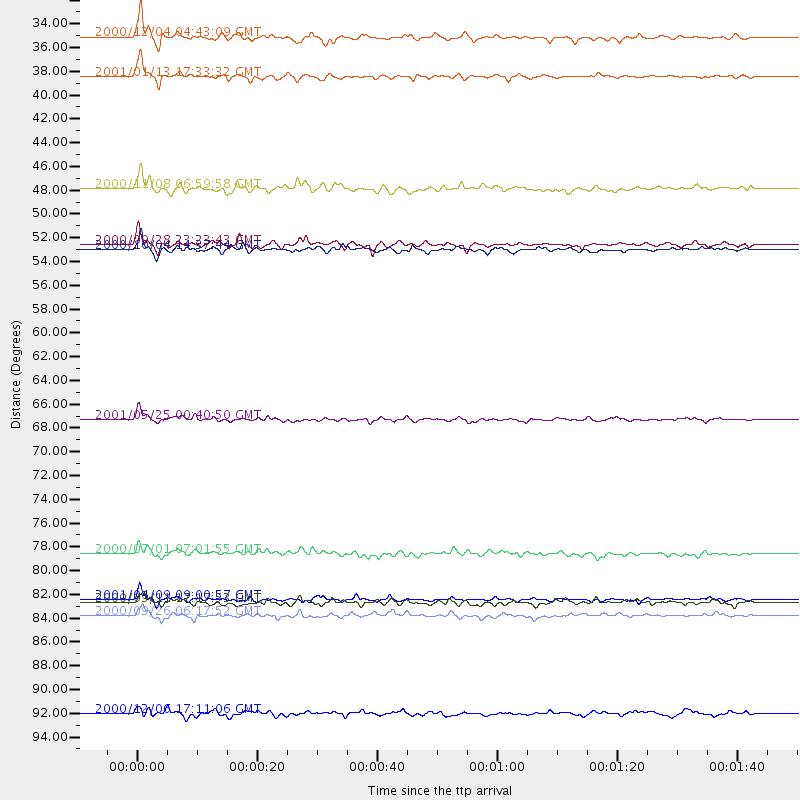
Events Processed for this Station
Download zip of receiver functions as SAC
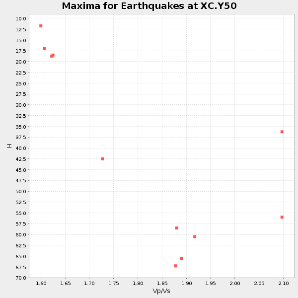
Plot maxima for each earthquake.
Events Used in the Stack
(11 events)| Radial Match | Distance | Baz | FERegion | Time | Lat/Lon | Depth | Magnitude |
| 93.77717 | 36.4 deg | 145.226 deg | El Salvador | 2001/01/13 17:33:32 GMT | (13.0, -88.7) | 60 km | 6.4 MB, 7.8 MS, 7.7 MW, 7.5 ME |
| 90.60482 | 85.5 deg | 240.321 deg | Tonga Islands | 2000/09/26 06:17:52 GMT | (-17.2, -173.9) | 56 km | 6.1 MB, 6.1 MS, 6.4 MW, 6.1 ME |
| 88.38819 | 52.1 deg | 115.731 deg | Windward Islands | 2000/10/04 14:37:44 GMT | (11.1, -62.6) | 110 km | 5.6 MB, 5.4 MS, 6.1 MW, 5.9 MD |
| 87.81747 | 67.6 deg | 310.716 deg | Kuril Islands | 2001/05/25 00:40:50 GMT | (44.3, 148.4) | 33 km | 6.1 MB, 6.7 MS, 6.7 MW, 6.6 MW |
| 87.14641 | 84.0 deg | 150.214 deg | Off Coast Of Central Chile | 2001/04/09 09:00:57 GMT | (-32.7, -73.1) | 11 km | 6.1 MB, 6.3 MS, 6.7 MW, 6.3 ME |
| 85.51389 | 46.6 deg | 135.05 deg | Panama-Colombia Border Region | 2000/11/08 06:59:58 GMT | (7.0, -77.8) | 17 km | 6.0 MB, 6.4 MS, 6.5 MW, 6.2 ML |
| 85.50311 | 32.7 deg | 152.4 deg | Near Coast Of Chiapas, Mexico | 2000/12/04 04:43:09 GMT | (14.9, -93.9) | 33 km | 5.6 MB, 5.7 MS, 6.0 MW, 5.9 MW |
| 85.22601 | 51.7 deg | 142.713 deg | Near Coast Of Ecuador | 2000/09/28 23:23:43 GMT | (-0.2, -80.6) | 23 km | 5.8 MB, 6.0 MS, 6.6 MW, 6.4 MW |
| 82.47874 | 79.8 deg | 308.637 deg | Near S. Coast Of Honshu, Japan | 2000/07/01 07:01:55 GMT | (34.2, 139.1) | 10 km | 6.0 MB, 6.1 MS, 6.2 MW, 6.2 MW |
| 82.124405 | 94.4 deg | 12.518 deg | Turkmenistan | 2000/12/06 17:11:06 GMT | (39.6, 54.8) | 30 km | 6.7 MB, 7.5 MS, 7.0 MW, 6.9 ME |
| 80.88868 | 84.3 deg | 240.982 deg | Tonga Islands | 2000/09/11 17:17:53 GMT | (-15.9, -173.7) | 115 km | 6.0 MB, 6.3 MW, 6.3 MW |
Losers
(0 events)| Radial Match | Distance | Baz | FERegion | Time | Lat/Lon | Depth | Magnitude | Reason |
