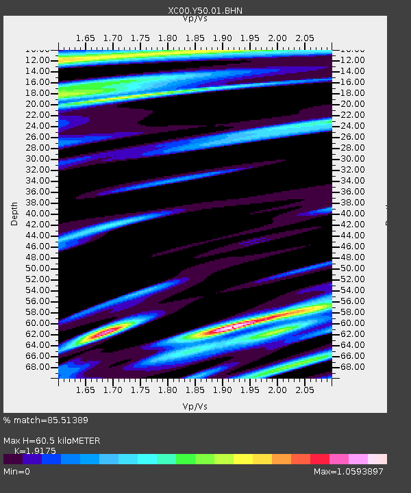
Y50 Y50 - Earthquake Result Viewer
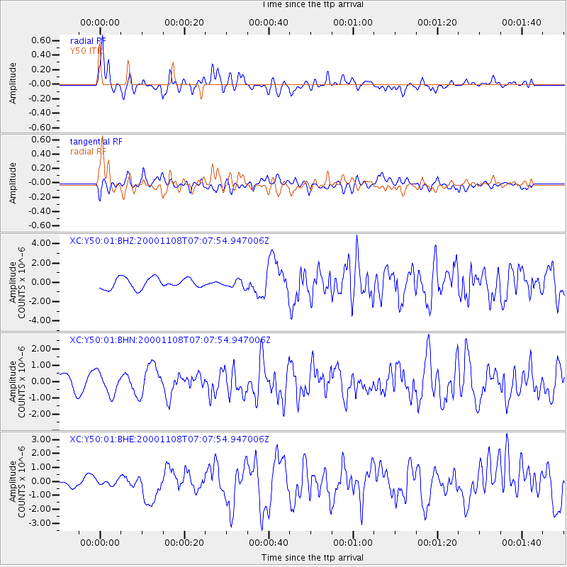
Earthquake location: Panama-Colombia Border Region
Earthquake latitude/longitude: 7.0/-77.8
Earthquake time(UTC): 2000/11/08 (313) 06:59:58 GMT
Earthquake Depth: 17 km
Earthquake Magnitude: 6.0 MB, 6.4 MS, 6.5 MW, 6.2 ML
Earthquake Catalog/Contributor: WHDF/NEIC
Network: XC Yellowstone Intermountain Seismic Array
Station: Y50 Y50
Lat/Lon: 45.15 N/108.97 W
Elevation: 1197 m
Distance: 46.6 deg
Az: 329.758 deg
Baz: 135.05 deg
Ray Param: 0.07053204
Estimated Moho Depth: 60.5 km
Estimated Crust Vp/Vs: 1.92
Assumed Crust Vp: 6.242 km/s
Estimated Crust Vs: 3.255 km/s
Estimated Crust Poisson's Ratio: 0.31
Radial Match: 85.51389 %
Radial Bump: 400
Transverse Match: 53.171272 %
Transverse Bump: 400
SOD ConfigId: 3744
Insert Time: 2010-02-26 14:58:11.323 +0000
GWidth: 2.5
Max Bumps: 400
Tol: 0.001

Signal To Noise

ChannelStoNSTALTA
XC:Y50:01:BHN:20001108T07:07:54.947006Z1.11338116.5767284E-75.906988E-7
XC:Y50:01:BHE:20001108T07:07:54.947006Z0.34826832.0760906E-75.961181E-7
XC:Y50:01:BHZ:20001108T07:07:54.947006Z0.72160813.897376E-75.400959E-7
Arrivals
Ps9.4 SECOND
PpPs27 SECOND
PsPs/PpSs36 SECOND