You are here: Home > Network List > XC00 - Yellowstone Intermountain Seismic Array Stations List
> Station Y50 Y50 > Earthquake Result Viewer
Y50 Y50 - Earthquake Result Viewer
| Earthquake location: |
Tonga Islands |
| Earthquake latitude/longitude: |
-15.9/-173.7 |
| Earthquake time(UTC): |
2000/09/11 (255) 17:17:53 GMT |
| Earthquake Depth: |
115 km |
| Earthquake Magnitude: |
6.0 MB, 6.3 MW, 6.3 MW |
| Earthquake Catalog/Contributor: |
WHDF/NEIC |
|
| Network: |
XC Yellowstone Intermountain Seismic Array |
| Station: |
Y50 Y50 |
| Lat/Lon: |
45.15 N/108.97 W |
| Elevation: |
1197 m |
|
| Distance: |
84.3 deg |
| Az: |
40.015 deg |
| Baz: |
240.982 deg |
| Ray Param: |
0.045296956 |
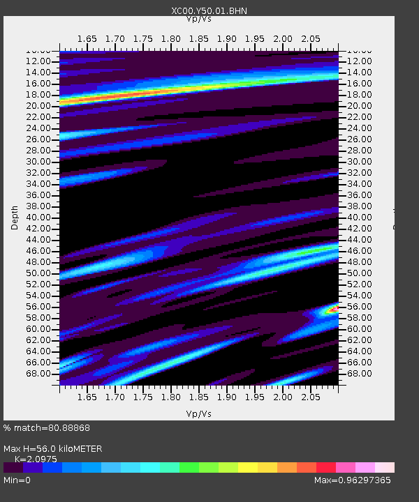
| Estimated Moho Depth: |
56.0 km |
| Estimated Crust Vp/Vs: |
2.10 |
| Assumed Crust Vp: |
6.242 km/s |
| Estimated Crust Vs: |
2.976 km/s |
| Estimated Crust Poisson's Ratio: |
0.35 |
|
| Radial Match: |
80.88868 % |
| Radial Bump: |
400 |
| Transverse Match: |
77.53356 % |
| Transverse Bump: |
400 |
| SOD ConfigId: |
16820 |
| Insert Time: |
2010-02-26 14:58:16.957 +0000 |
| GWidth: |
2.5 |
| Max Bumps: |
400 |
| Tol: |
0.001 |
|

Signal To Noise
| Channel | StoN | STA | LTA |
| XC:Y50:01:BHN:20000911T17:29:41.519995Z | 2.2249956 | 4.785964E-7 | 2.1509993E-7 |
| XC:Y50:01:BHE:20000911T17:29:41.519995Z | 1.8362825 | 4.1361147E-7 | 2.2524392E-7 |
| XC:Y50:01:BHZ:20000911T17:29:41.519995Z | 12.330984 | 2.0366385E-6 | 1.6516432E-7 |
| Arrivals |
| Ps | 10 SECOND |
| PpPs | 27 SECOND |
| PsPs/PpSs | 37 SECOND |


