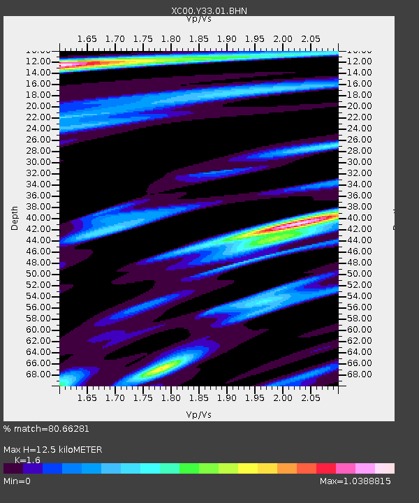
Y33 Y33 - Earthquake Result Viewer
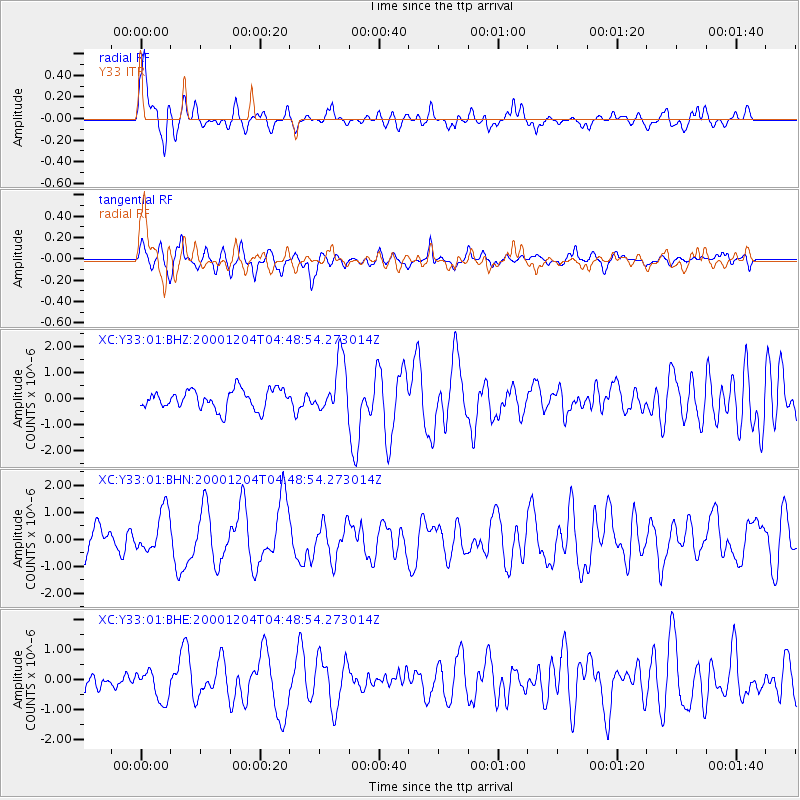
Earthquake location: Near Coast Of Chiapas, Mexico
Earthquake latitude/longitude: 14.9/-93.9
Earthquake time(UTC): 2000/12/04 (339) 04:43:09 GMT
Earthquake Depth: 33 km
Earthquake Magnitude: 5.6 MB, 5.7 MS, 6.0 MW, 5.9 MW
Earthquake Catalog/Contributor: WHDF/NEIC
Network: XC Yellowstone Intermountain Seismic Array
Station: Y33 Y33
Lat/Lon: 43.23 N/108.98 W
Elevation: 1756 m
Distance: 31.1 deg
Az: 338.442 deg
Baz: 150.916 deg
Ray Param: 0.079138204
Estimated Moho Depth: 12.5 km
Estimated Crust Vp/Vs: 1.60
Assumed Crust Vp: 6.161 km/s
Estimated Crust Vs: 3.851 km/s
Estimated Crust Poisson's Ratio: 0.18
Radial Match: 80.66281 %
Radial Bump: 400
Transverse Match: 78.56841 %
Transverse Bump: 400
SOD ConfigId: 16820
Insert Time: 2010-02-26 14:58:21.516 +0000
GWidth: 2.5
Max Bumps: 400
Tol: 0.001

Signal To Noise

ChannelStoNSTALTA
XC:Y33:01:BHN:20001204T04:48:54.273014Z1.70996567.4737494E-74.3707016E-7
XC:Y33:01:BHE:20001204T04:48:54.273014Z1.33879765.1353925E-73.8358243E-7
XC:Y33:01:BHZ:20001204T04:48:54.273014Z2.67761521.0062474E-63.7579986E-7
Arrivals
Ps1.3 SECOND
PpPs4.9 SECOND
PsPs/PpSs6.2 SECOND