
Station XC Y33 - Y33
Network: XC00 - Yellowstone Intermountain Seismic Array
Nearby stations (2 deg radius)
| Station | Name | (Lat, Lon) | Start / End | Elevation |
| Y33 | Y33 | (43.23, -108.98) | 2000-06-19 / 2001-12-31 | 1756 m |
| Crust2 Type: | Q0,orogen/46km no ice, Rockies, Tarim Basin, 4 km seds. |
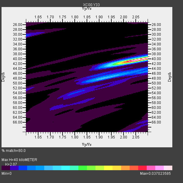
| Thickness Estimate: | 40 km |
| Thickness StdDev: | 0.5 km |
| Vp/Vs Estimate: | 2.07 |
| Vp/Vs StdDev: | 0.03 |
| Vs Estimate: | 2.976 km/s |
| Poisson's Ratio: | 0.35 |
| Peak Value: | 0.04 |
| Assumed Vp: | 6.161 km/s |
| Ps Weight: | 0.33333334 |
| PpPs Weight: | 0.33333334 |
| PsPs Weight: | 0.33333328 |
| Residual Complexity: | 0.296 |
| Nearby stations H: | +- |
| (2.0 deg) Vp/Vs: | +- |
3 with match > 90% ( 30.0 %) and 10 with match > 80% ( 100.0 %) out of 10.
Download stack as xyz text file.
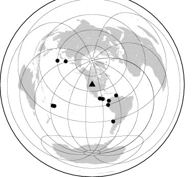
Azimuth Distribution of Events:
Prior Results for this Station
| Study | Thickness | Vp/Vs | Vp | Vs | Poissons Ratio | Extra |
| EARS | 40 km | 2.07 | 6.161 km/s | 2.976 km/s | 0.35 | |
| Crust2.0 | 46 km | 1.75 | 6.161 km/s | 3.511 km/s | 0.26 | Q0,orogen/46km no ice, Rockies, Tarim Basin, 4 km seds. |
| Global Maxima | 40 km | 2.07 | 6.161 km/s | 2.976 km/s | 0.35 | amp=0.037023585 |
| Local Maxima 1 | 45 km | 2.09 | 6.161 km/s | 2.955 km/s | 0.35 | amp=0.0074678105 |
| Local Maxima 2 | 42 km | 1.97 | 6.161 km/s | 3.127 km/s | 0.33 | amp=0.005874816 |
| Local Maxima 3 | 30 km | 1.60 | 6.161 km/s | 3.851 km/s | 0.18 | amp=0.0042731343 |
| Local Maxima 4 | 45 km | 2.03 | 6.161 km/s | 3.039 km/s | 0.34 | amp=0.004236857 |
| Predicted Arrivals for vertical incidence (zero ray parameter) | |
| Ps | 6.95 SECOND |
| PpPs | 19.93 SECOND |
| PsPs/PpSs | 26.88 SECOND |
Events Processed for this Station
Download zip of receiver functions as SAC
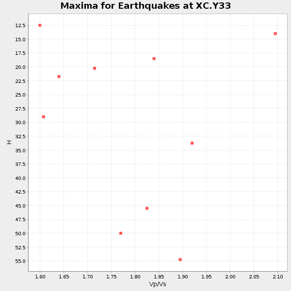
Plot maxima for each earthquake.
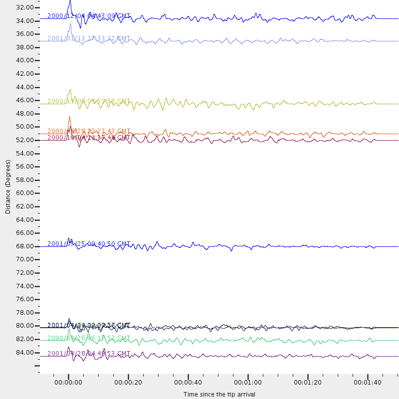
Events Used in the Stack
(10 events)| Radial Match | Distance | Baz | FERegion | Time | Lat/Lon | Depth | Magnitude |
| 92.23773 | 68.9 deg | 311.289 deg | Kuril Islands | 2001/05/25 00:40:50 GMT | (44.3, 148.4) | 33 km | 6.1 MB, 6.7 MS, 6.7 MW, 6.6 MW |
| 91.06688 | 82.4 deg | 150.092 deg | Off Coast Of Central Chile | 2001/04/09 09:00:57 GMT | (-32.7, -73.1) | 11 km | 6.1 MB, 6.3 MS, 6.7 MW, 6.3 ME |
| 90.26639 | 50.2 deg | 141.745 deg | Near Coast Of Ecuador | 2000/09/28 23:23:43 GMT | (-0.2, -80.6) | 23 km | 5.8 MB, 6.0 MS, 6.6 MW, 6.4 MW |
| 89.993576 | 34.8 deg | 143.648 deg | El Salvador | 2001/01/13 17:33:32 GMT | (13.0, -88.7) | 60 km | 6.4 MB, 7.8 MS, 7.7 MW, 7.5 ME |
| 89.67003 | 84.5 deg | 240.46 deg | Tonga Islands | 2000/09/26 06:17:52 GMT | (-17.2, -173.9) | 56 km | 6.1 MB, 6.1 MS, 6.4 MW, 6.1 ME |
| 88.945526 | 51.3 deg | 114.345 deg | Windward Islands | 2000/10/04 14:37:44 GMT | (11.1, -62.6) | 110 km | 5.6 MB, 5.4 MS, 6.1 MW, 5.9 MD |
| 87.6636 | 45.3 deg | 133.708 deg | Panama-Colombia Border Region | 2000/11/08 06:59:58 GMT | (7.0, -77.8) | 17 km | 6.0 MB, 6.4 MS, 6.5 MW, 6.2 ML |
| 81.2883 | 82.4 deg | 304.374 deg | Southeast Of Honshu, Japan | 2001/04/14 23:27:26 GMT | (30.1, 141.8) | 10 km | 6.0 MB, 5.8 MS, 6.0 MW, 6.0 ME |
| 80.66281 | 31.1 deg | 150.916 deg | Near Coast Of Chiapas, Mexico | 2000/12/04 04:43:09 GMT | (14.9, -93.9) | 33 km | 5.6 MB, 5.7 MS, 6.0 MW, 5.9 MW |
| 80.07844 | 87.1 deg | 241.998 deg | Fiji Islands Region | 2001/04/28 04:49:53 GMT | (-18.1, -176.9) | 352 km | 6.2 MB, 6.8 MW, 6.8 MW |
Losers
(0 events)| Radial Match | Distance | Baz | FERegion | Time | Lat/Lon | Depth | Magnitude | Reason |
