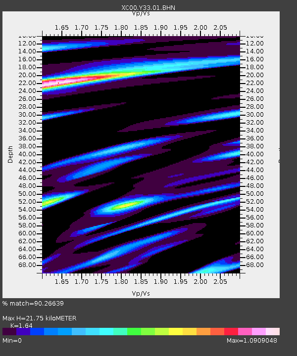
Y33 Y33 - Earthquake Result Viewer
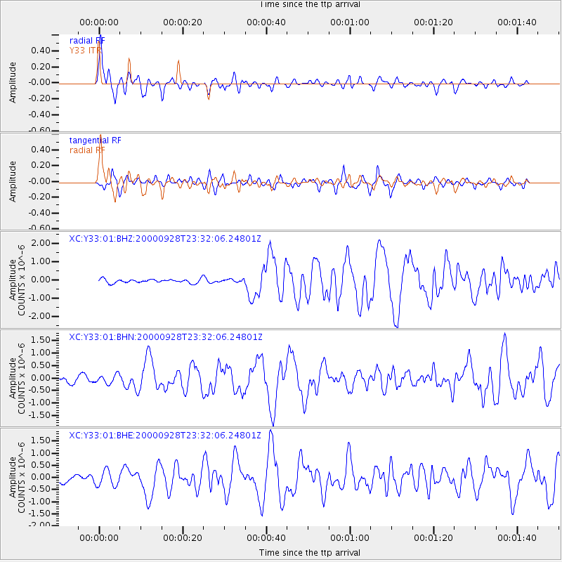
Earthquake location: Near Coast Of Ecuador
Earthquake latitude/longitude: -0.2/-80.6
Earthquake time(UTC): 2000/09/28 (272) 23:23:43 GMT
Earthquake Depth: 23 km
Earthquake Magnitude: 5.8 MB, 6.0 MS, 6.6 MW, 6.4 MW
Earthquake Catalog/Contributor: WHDF/NEIC
Network: XC Yellowstone Intermountain Seismic Array
Station: Y33 Y33
Lat/Lon: 43.23 N/108.98 W
Elevation: 1756 m
Distance: 50.2 deg
Az: 333.093 deg
Baz: 141.745 deg
Ray Param: 0.068196885
Estimated Moho Depth: 21.75 km
Estimated Crust Vp/Vs: 1.64
Assumed Crust Vp: 6.161 km/s
Estimated Crust Vs: 3.757 km/s
Estimated Crust Poisson's Ratio: 0.20
Radial Match: 90.26639 %
Radial Bump: 400
Transverse Match: 78.69909 %
Transverse Bump: 400
SOD ConfigId: 3744
Insert Time: 2010-02-26 14:58:22.624 +0000
GWidth: 2.5
Max Bumps: 400
Tol: 0.001

Signal To Noise

ChannelStoNSTALTA
XC:Y33:01:BHN:20000928T23:32:06.24801Z1.27884461.776503E-71.389147E-7
XC:Y33:01:BHE:20000928T23:32:06.24801Z2.17495183.2773187E-71.5068466E-7
XC:Y33:01:BHZ:20000928T23:32:06.24801Z0.7428437.601897E-81.0233518E-7
Arrivals
Ps2.4 SECOND
PpPs8.8 SECOND
PsPs/PpSs11 SECOND