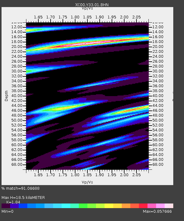
Y33 Y33 - Earthquake Result Viewer
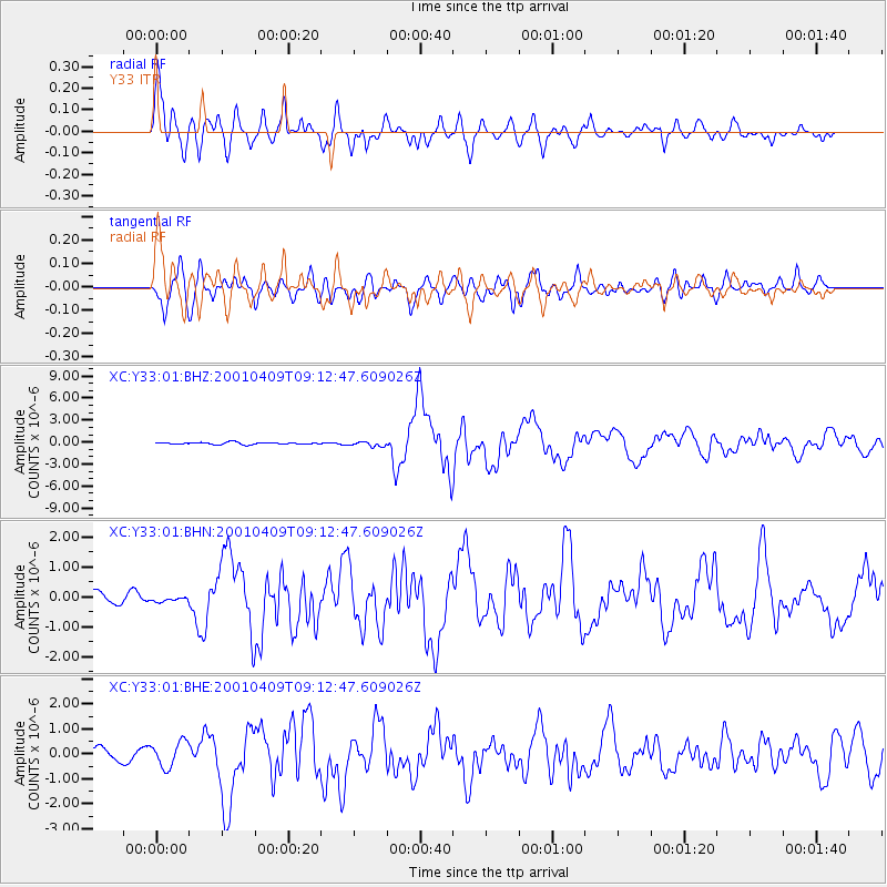
Earthquake location: Off Coast Of Central Chile
Earthquake latitude/longitude: -32.7/-73.1
Earthquake time(UTC): 2001/04/09 (099) 09:00:57 GMT
Earthquake Depth: 11 km
Earthquake Magnitude: 6.1 MB, 6.3 MS, 6.7 MW, 6.3 ME
Earthquake Catalog/Contributor: WHDF/NEIC
Network: XC Yellowstone Intermountain Seismic Array
Station: Y33 Y33
Lat/Lon: 43.23 N/108.98 W
Elevation: 1756 m
Distance: 82.4 deg
Az: 334.401 deg
Baz: 150.092 deg
Ray Param: 0.046939246
Estimated Moho Depth: 18.5 km
Estimated Crust Vp/Vs: 1.84
Assumed Crust Vp: 6.161 km/s
Estimated Crust Vs: 3.348 km/s
Estimated Crust Poisson's Ratio: 0.29
Radial Match: 91.06688 %
Radial Bump: 400
Transverse Match: 76.641594 %
Transverse Bump: 400
SOD ConfigId: 4714
Insert Time: 2010-02-26 14:58:29.844 +0000
GWidth: 2.5
Max Bumps: 400
Tol: 0.001

Signal To Noise

ChannelStoNSTALTA
XC:Y33:01:BHN:20010409T09:12:47.609026Z0.304443936.007944E-81.9734155E-7
XC:Y33:01:BHE:20010409T09:12:47.609026Z1.83433275.034045E-72.7443468E-7
XC:Y33:01:BHZ:20010409T09:12:47.609026Z2.2722933.159121E-71.3902788E-7
Arrivals
Ps2.6 SECOND
PpPs8.3 SECOND
PsPs/PpSs11 SECOND