You are here: Home > Network List > XC00 - Yellowstone Intermountain Seismic Array Stations List
> Station Y33 Y33 > Earthquake Result Viewer
Y33 Y33 - Earthquake Result Viewer
| Earthquake location: |
Fiji Islands Region |
| Earthquake latitude/longitude: |
-18.1/-176.9 |
| Earthquake time(UTC): |
2001/04/28 (118) 04:49:53 GMT |
| Earthquake Depth: |
352 km |
| Earthquake Magnitude: |
6.2 MB, 6.8 MW, 6.8 MW |
| Earthquake Catalog/Contributor: |
WHDF/NEIC |
|
| Network: |
XC Yellowstone Intermountain Seismic Array |
| Station: |
Y33 Y33 |
| Lat/Lon: |
43.23 N/108.98 W |
| Elevation: |
1756 m |
|
| Distance: |
87.1 deg |
| Az: |
42.715 deg |
| Baz: |
241.998 deg |
| Ray Param: |
0.042673297 |
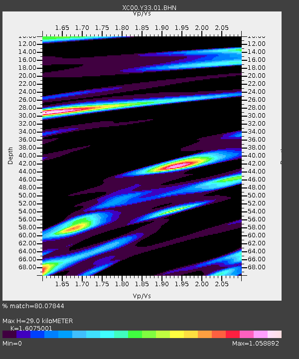
| Estimated Moho Depth: |
29.0 km |
| Estimated Crust Vp/Vs: |
1.61 |
| Assumed Crust Vp: |
6.161 km/s |
| Estimated Crust Vs: |
3.833 km/s |
| Estimated Crust Poisson's Ratio: |
0.18 |
|
| Radial Match: |
80.07844 % |
| Radial Bump: |
400 |
| Transverse Match: |
68.08303 % |
| Transverse Bump: |
400 |
| SOD ConfigId: |
4714 |
| Insert Time: |
2010-02-26 14:58:31.315 +0000 |
| GWidth: |
2.5 |
| Max Bumps: |
400 |
| Tol: |
0.001 |
|
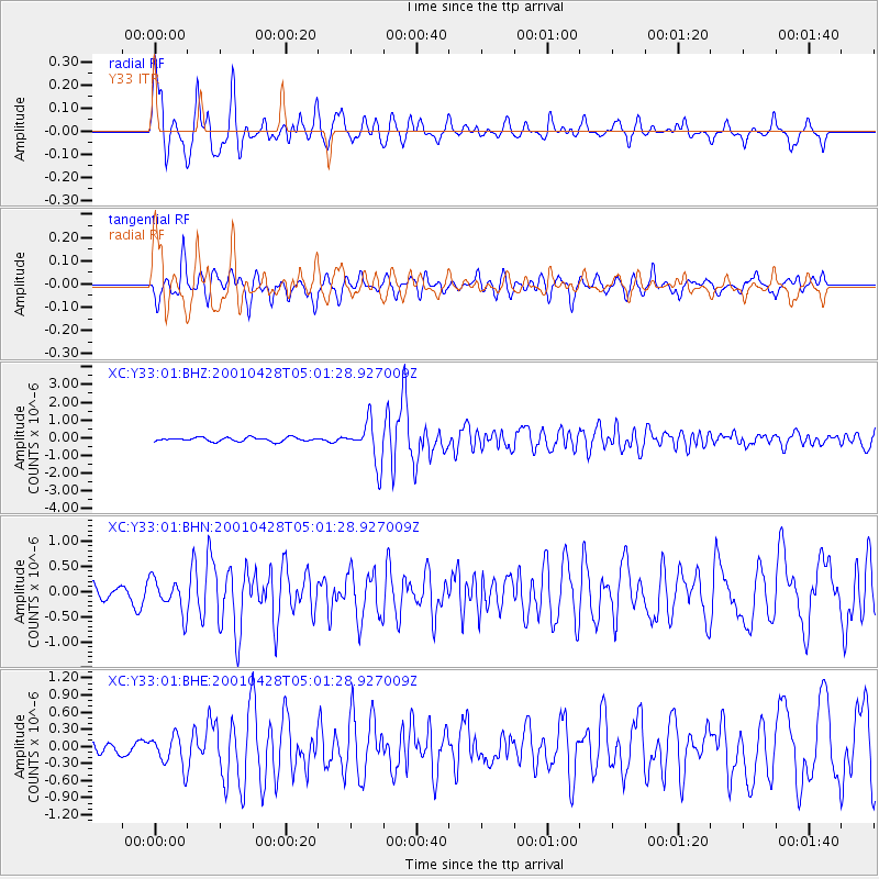
Signal To Noise
| Channel | StoN | STA | LTA |
| XC:Y33:01:BHN:20010428T05:01:28.927009Z | 1.2182918 | 3.2357664E-7 | 2.6559866E-7 |
| XC:Y33:01:BHE:20010428T05:01:28.927009Z | 1.5696981 | 2.685235E-7 | 1.7106699E-7 |
| XC:Y33:01:BHZ:20010428T05:01:28.927009Z | 10.50906 | 1.1652198E-6 | 1.1087764E-7 |
| Arrivals |
| Ps | 2.9 SECOND |
| PpPs | 12 SECOND |
| PsPs/PpSs | 15 SECOND |


