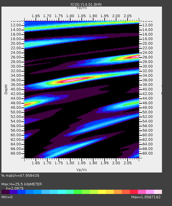
Y14 Y14 - Earthquake Result Viewer
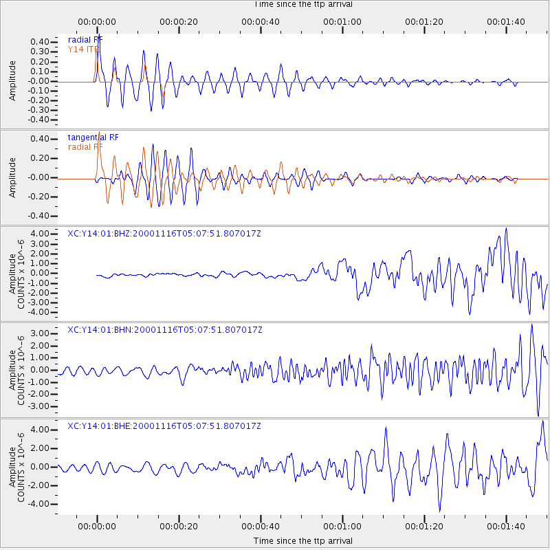
Earthquake location: New Ireland Region, P.N.G.
Earthquake latitude/longitude: -4.0/152.2
Earthquake time(UTC): 2000/11/16 (321) 04:54:56 GMT
Earthquake Depth: 33 km
Earthquake Magnitude: 6.0 MB, 8.2 MS, 8.0 MW, 8.0 ME
Earthquake Catalog/Contributor: WHDF/NEIC
Network: XC Yellowstone Intermountain Seismic Array
Station: Y14 Y14
Lat/Lon: 44.99 N/112.46 W
Elevation: 1863 m
Distance: 96.6 deg
Az: 45.332 deg
Baz: 270.974 deg
Ray Param: 0.04045211
Estimated Moho Depth: 25.5 km
Estimated Crust Vp/Vs: 2.10
Assumed Crust Vp: 6.577 km/s
Estimated Crust Vs: 3.136 km/s
Estimated Crust Poisson's Ratio: 0.35
Radial Match: 87.959435 %
Radial Bump: 400
Transverse Match: 71.70533 %
Transverse Bump: 400
SOD ConfigId: 3744
Insert Time: 2010-02-26 14:58:36.406 +0000
GWidth: 2.5
Max Bumps: 400
Tol: 0.001

Signal To Noise

ChannelStoNSTALTA
XC:Y14:01:BHN:20001116T05:07:51.807017Z0.96568792.3456079E-72.4289503E-7
XC:Y14:01:BHE:20001116T05:07:51.807017Z1.26563534.6273178E-73.6561224E-7
XC:Y14:01:BHZ:20001116T05:07:51.807017Z1.72400552.0892419E-71.2118534E-7
Arrivals
Ps4.3 SECOND
PpPs12 SECOND
PsPs/PpSs16 SECOND