
Station XC Y14 - Y14
Network: XC00 - Yellowstone Intermountain Seismic Array
Nearby stations (2 deg radius)
| Station | Name | (Lat, Lon) | Start / End | Elevation |
| Y14 | Y14 | (44.99, -112.46) | 2000-07-14 / 2001-12-31 | 1863 m |
| Crust2 Type: | H3,early/mid Proter. shield, Finland, 0.5 km seds. |
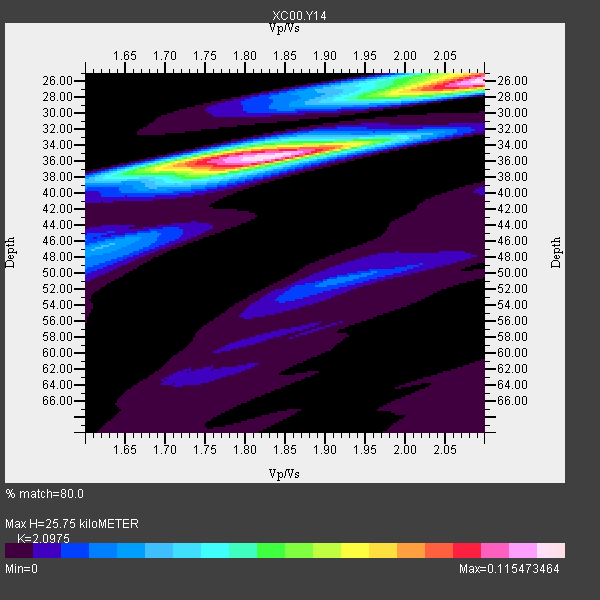
| Thickness Estimate: | 26 km |
| Thickness StdDev: | 4.8 km |
| Vp/Vs Estimate: | 2.10 |
| Vp/Vs StdDev: | 0.14 |
| Vs Estimate: | 3.136 km/s |
| Poisson's Ratio: | 0.35 |
| Peak Value: | 0.12 |
| Assumed Vp: | 6.577 km/s |
| Ps Weight: | 0.33333334 |
| PpPs Weight: | 0.33333334 |
| PsPs Weight: | 0.33333328 |
| Residual Complexity: | 0.795 |
| Nearby stations H: | +- |
| (2.0 deg) Vp/Vs: | +- |
2 with match > 90% ( 22.222221 %) and 9 with match > 80% ( 100.0 %) out of 9.
Download stack as xyz text file.
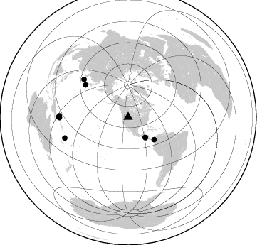
Azimuth Distribution of Events:
Prior Results for this Station
| Study | Thickness | Vp/Vs | Vp | Vs | Poissons Ratio | Extra |
| EARS | 26 km | 2.10 | 6.577 km/s | 3.136 km/s | 0.35 | |
| Crust2.0 | 46 km | 1.78 | 6.577 km/s | 3.701 km/s | 0.27 | H3,early/mid Proter. shield, Finland, 0.5 km seds. |
| Global Maxima | 26 km | 2.10 | 6.577 km/s | 3.136 km/s | 0.35 | amp=0.115473464 |
| Local Maxima 1 | 36 km | 1.82 | 6.577 km/s | 3.614 km/s | 0.28 | amp=0.110597305 |
| Local Maxima 2 | 36 km | 1.74 | 6.577 km/s | 3.785 km/s | 0.25 | amp=0.0503031 |
| Local Maxima 3 | 25 km | 2.05 | 6.577 km/s | 3.216 km/s | 0.34 | amp=0.040212147 |
| Local Maxima 4 | 27 km | 2.10 | 6.577 km/s | 3.136 km/s | 0.35 | amp=0.023961294 |
| Predicted Arrivals for vertical incidence (zero ray parameter) | |
| Ps | 4.30 SECOND |
| PpPs | 12.13 SECOND |
| PsPs/PpSs | 16.42 SECOND |
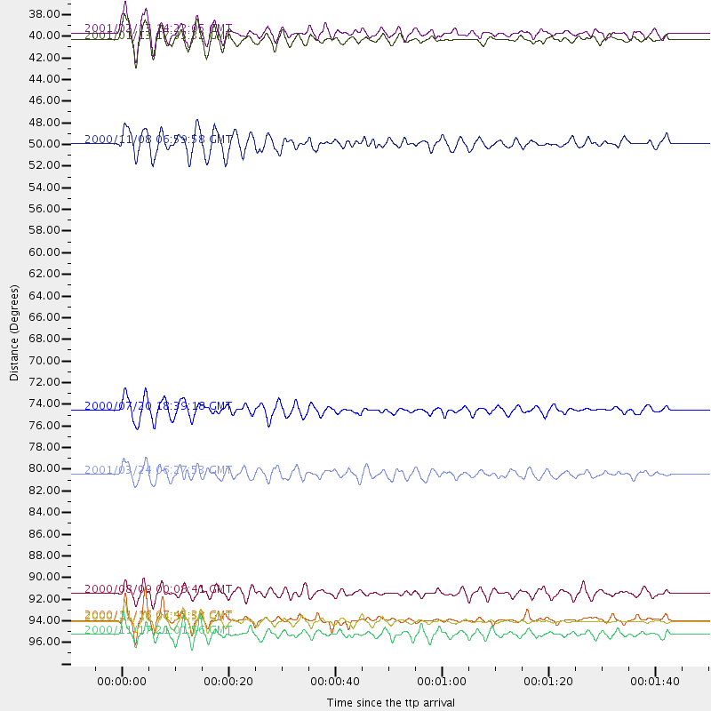
Events Processed for this Station
Download zip of receiver functions as SAC
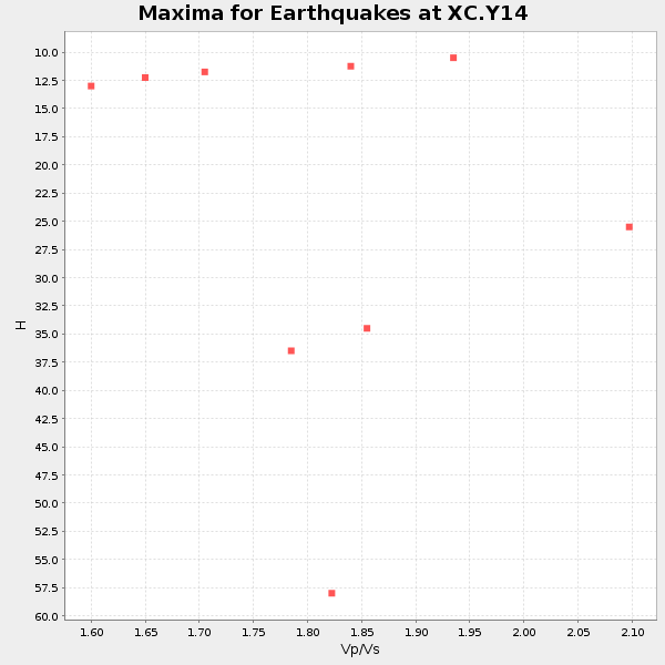
Plot maxima for each earthquake.
Events Used in the Stack
(9 events)| Radial Match | Distance | Baz | FERegion | Time | Lat/Lon | Depth | Magnitude |
| 92.97636 | 37.7 deg | 140.025 deg | El Salvador | 2001/01/13 17:33:32 GMT | (13.0, -88.7) | 60 km | 6.4 MB, 7.8 MS, 7.7 MW, 7.5 ME |
| 90.53138 | 37.1 deg | 139.941 deg | El Salvador | 2001/02/13 14:22:05 GMT | (13.7, -88.9) | 10 km | 5.5 MB, 6.5 MS, 6.6 MW, 6.1 MD |
| 87.959435 | 96.6 deg | 270.974 deg | New Ireland Region, P.N.G. | 2000/11/16 04:54:56 GMT | (-4.0, 152.2) | 33 km | 6.0 MB, 8.2 MS, 8.0 MW, 8.0 ME |
| 87.58649 | 96.4 deg | 269.626 deg | New Ireland Region, P.N.G. | 2000/11/16 07:45:32 GMT | (-4.8, 153.2) | 33 km | 6.5 MB, 7.2 MS |
| 86.94153 | 97.9 deg | 270.167 deg | New Britain Region, P.N.G. | 2000/11/17 21:01:56 GMT | (-5.5, 151.8) | 33 km | 6.2 MB, 8.0 MS, 7.6 MW, 6.9 ME |
| 83.16978 | 81.7 deg | 310.533 deg | Western Honshu, Japan | 2001/03/24 06:27:53 GMT | (34.1, 132.5) | 50 km | 6.4 MB, 6.5 MS, 6.8 MW, 6.4 ME |
| 82.62326 | 48.3 deg | 130.926 deg | Panama-Colombia Border Region | 2000/11/08 06:59:58 GMT | (7.0, -77.8) | 17 km | 6.0 MB, 6.4 MS, 6.5 MW, 6.2 ML |
| 81.35759 | 75.3 deg | 307.01 deg | Near East Coast Of Honshu, Japan | 2000/07/20 18:39:18 GMT | (36.5, 141.0) | 47 km | 6.1 MB, 5.4 MS, 6.1 ME, 6.0 MW |
| 81.009674 | 93.8 deg | 251.672 deg | Vanuatu Islands | 2000/08/09 00:08:41 GMT | (-15.7, 168.0) | 33 km | 6.3 MB, 6.0 MS, 6.4 MW, 6.3 MW |
Losers
(0 events)| Radial Match | Distance | Baz | FERegion | Time | Lat/Lon | Depth | Magnitude | Reason |
