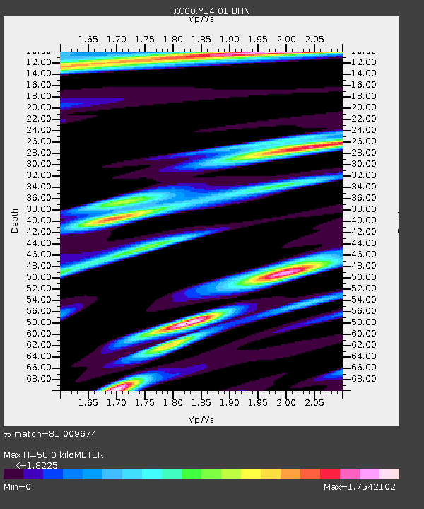
Y14 Y14 - Earthquake Result Viewer
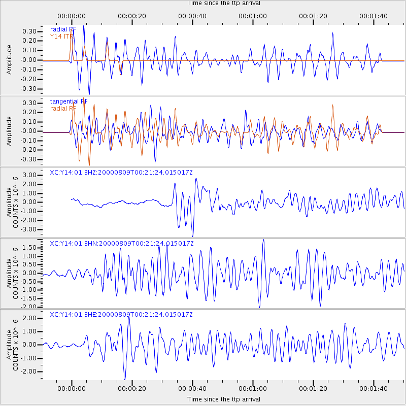
Earthquake location: Vanuatu Islands
Earthquake latitude/longitude: -15.7/168.0
Earthquake time(UTC): 2000/08/09 (222) 00:08:41 GMT
Earthquake Depth: 33 km
Earthquake Magnitude: 6.3 MB, 6.0 MS, 6.4 MW, 6.3 MW
Earthquake Catalog/Contributor: WHDF/NEIC
Network: XC Yellowstone Intermountain Seismic Array
Station: Y14 Y14
Lat/Lon: 44.99 N/112.46 W
Elevation: 1863 m
Distance: 93.8 deg
Az: 44.375 deg
Baz: 251.672 deg
Ray Param: 0.041187156
Estimated Moho Depth: 58.0 km
Estimated Crust Vp/Vs: 1.82
Assumed Crust Vp: 6.577 km/s
Estimated Crust Vs: 3.609 km/s
Estimated Crust Poisson's Ratio: 0.28
Radial Match: 81.009674 %
Radial Bump: 395
Transverse Match: 74.45328 %
Transverse Bump: 400
SOD ConfigId: 3744
Insert Time: 2010-02-26 14:58:38.579 +0000
GWidth: 2.5
Max Bumps: 400
Tol: 0.001

Signal To Noise

ChannelStoNSTALTA
XC:Y14:01:BHN:20000809T00:21:24.015017Z1.75632951.9253758E-71.0962498E-7
XC:Y14:01:BHE:20000809T00:21:24.015017Z1.66702322.1326727E-71.2793299E-7
XC:Y14:01:BHZ:20000809T00:21:24.015017Z3.55358177.560411E-72.1275467E-7
Arrivals
Ps7.4 SECOND
PpPs24 SECOND
PsPs/PpSs32 SECOND