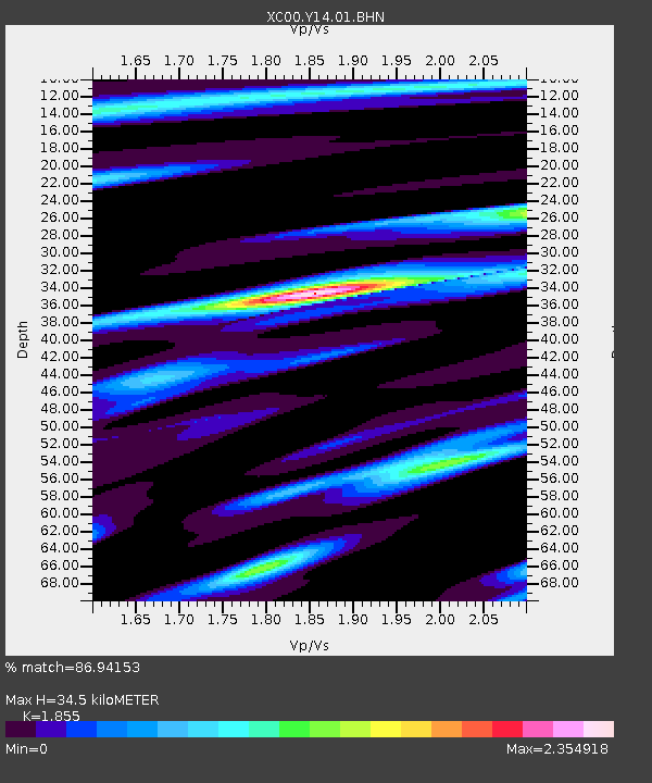
Y14 Y14 - Earthquake Result Viewer
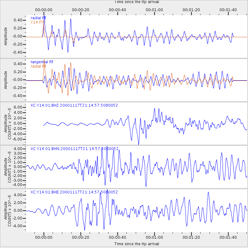
Earthquake location: New Britain Region, P.N.G.
Earthquake latitude/longitude: -5.5/151.8
Earthquake time(UTC): 2000/11/17 (322) 21:01:56 GMT
Earthquake Depth: 33 km
Earthquake Magnitude: 6.2 MB, 8.0 MS, 7.6 MW, 6.9 ME
Earthquake Catalog/Contributor: WHDF/NEIC
Network: XC Yellowstone Intermountain Seismic Array
Station: Y14 Y14
Lat/Lon: 44.99 N/112.46 W
Elevation: 1863 m
Distance: 97.9 deg
Az: 45.466 deg
Baz: 270.167 deg
Ray Param: 0.040046588
Estimated Moho Depth: 34.5 km
Estimated Crust Vp/Vs: 1.86
Assumed Crust Vp: 6.577 km/s
Estimated Crust Vs: 3.546 km/s
Estimated Crust Poisson's Ratio: 0.30
Radial Match: 86.94153 %
Radial Bump: 400
Transverse Match: 76.294174 %
Transverse Bump: 400
SOD ConfigId: 16820
Insert Time: 2010-02-26 14:58:39.610 +0000
GWidth: 2.5
Max Bumps: 400
Tol: 0.001

Signal To Noise

ChannelStoNSTALTA
XC:Y14:01:BHN:20001117T21:14:57.508005Z1.60044654.2353466E-72.6463533E-7
XC:Y14:01:BHE:20001117T21:14:57.508005Z3.14882338.36931E-72.6579167E-7
XC:Y14:01:BHZ:20001117T21:14:57.508005Z2.273327.2424376E-73.1858414E-7
Arrivals
Ps4.6 SECOND
PpPs15 SECOND
PsPs/PpSs19 SECOND