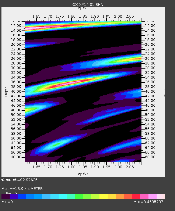
Y14 Y14 - Earthquake Result Viewer
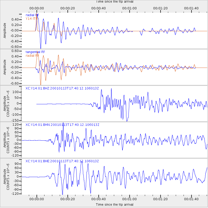
Earthquake location: El Salvador
Earthquake latitude/longitude: 13.0/-88.7
Earthquake time(UTC): 2001/01/13 (013) 17:33:32 GMT
Earthquake Depth: 60 km
Earthquake Magnitude: 6.4 MB, 7.8 MS, 7.7 MW, 7.5 ME
Earthquake Catalog/Contributor: WHDF/NEIC
Network: XC Yellowstone Intermountain Seismic Array
Station: Y14 Y14
Lat/Lon: 44.99 N/112.46 W
Elevation: 1863 m
Distance: 37.7 deg
Az: 332.107 deg
Baz: 140.025 deg
Ray Param: 0.07579282
Estimated Moho Depth: 13.0 km
Estimated Crust Vp/Vs: 1.60
Assumed Crust Vp: 6.577 km/s
Estimated Crust Vs: 4.111 km/s
Estimated Crust Poisson's Ratio: 0.18
Radial Match: 92.97636 %
Radial Bump: 400
Transverse Match: 89.97966 %
Transverse Bump: 400
SOD ConfigId: 16820
Insert Time: 2010-02-26 14:58:42.946 +0000
GWidth: 2.5
Max Bumps: 400
Tol: 0.001

Signal To Noise

ChannelStoNSTALTA
XC:Y14:01:BHN:20010113T17:40:12.106013Z2.95302687.253997E-72.4564616E-7
XC:Y14:01:BHE:20010113T17:40:12.106013Z0.705294255.161625E-77.3184E-7
XC:Y14:01:BHZ:20010113T17:40:12.106013Z4.53176361.7434995E-63.847287E-7
Arrivals
Ps1.3 SECOND
PpPs4.7 SECOND
PsPs/PpSs6.0 SECOND