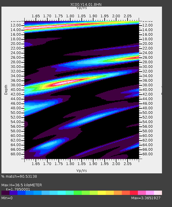
Y14 Y14 - Earthquake Result Viewer

Earthquake location: El Salvador
Earthquake latitude/longitude: 13.7/-88.9
Earthquake time(UTC): 2001/02/13 (044) 14:22:05 GMT
Earthquake Depth: 10 km
Earthquake Magnitude: 5.5 MB, 6.5 MS, 6.6 MW, 6.1 MD
Earthquake Catalog/Contributor: WHDF/NEIC
Network: XC Yellowstone Intermountain Seismic Array
Station: Y14 Y14
Lat/Lon: 44.99 N/112.46 W
Elevation: 1863 m
Distance: 37.1 deg
Az: 331.977 deg
Baz: 139.941 deg
Ray Param: 0.076337606
Estimated Moho Depth: 36.5 km
Estimated Crust Vp/Vs: 1.79
Assumed Crust Vp: 6.577 km/s
Estimated Crust Vs: 3.685 km/s
Estimated Crust Poisson's Ratio: 0.27
Radial Match: 90.53138 %
Radial Bump: 350
Transverse Match: 86.0746 %
Transverse Bump: 400
SOD ConfigId: 3744
Insert Time: 2010-02-26 14:58:44.109 +0000
GWidth: 2.5
Max Bumps: 400
Tol: 0.001

Signal To Noise

ChannelStoNSTALTA
XC:Y14:01:BHN:20010213T14:28:45.208Z1.56862352.1998581E-71.402413E-7
XC:Y14:01:BHE:20010213T14:28:45.208Z0.83658752.5788555E-73.082589E-7
XC:Y14:01:BHZ:20010213T14:28:45.208Z1.62953784.4824816E-72.7507687E-7
Arrivals
Ps4.7 SECOND
PpPs14 SECOND
PsPs/PpSs19 SECOND