You are here: Home > Network List > XC00 - Yellowstone Intermountain Seismic Array Stations List
> Station Y32 Y32 > Earthquake Result Viewer
Y32 Y32 - Earthquake Result Viewer
| Earthquake location: |
Tonga Islands |
| Earthquake latitude/longitude: |
-15.9/-173.7 |
| Earthquake time(UTC): |
2000/09/11 (255) 17:17:53 GMT |
| Earthquake Depth: |
115 km |
| Earthquake Magnitude: |
6.0 MB, 6.3 MW, 6.3 MW |
| Earthquake Catalog/Contributor: |
WHDF/NEIC |
|
| Network: |
XC Yellowstone Intermountain Seismic Array |
| Station: |
Y32 Y32 |
| Lat/Lon: |
43.58 N/109.45 W |
| Elevation: |
2138 m |
|
| Distance: |
83.3 deg |
| Az: |
41.226 deg |
| Baz: |
240.775 deg |
| Ray Param: |
0.04604826 |
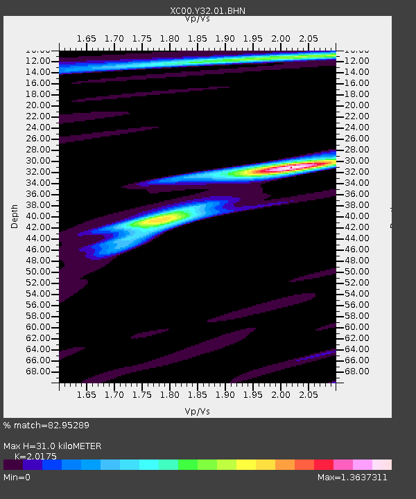
| Estimated Moho Depth: |
31.0 km |
| Estimated Crust Vp/Vs: |
2.02 |
| Assumed Crust Vp: |
6.161 km/s |
| Estimated Crust Vs: |
3.054 km/s |
| Estimated Crust Poisson's Ratio: |
0.34 |
|
| Radial Match: |
82.95289 % |
| Radial Bump: |
400 |
| Transverse Match: |
73.41336 % |
| Transverse Bump: |
400 |
| SOD ConfigId: |
16820 |
| Insert Time: |
2010-02-26 14:58:57.930 +0000 |
| GWidth: |
2.5 |
| Max Bumps: |
400 |
| Tol: |
0.001 |
|

Signal To Noise
| Channel | StoN | STA | LTA |
| XC:Y32:01:BHN:20000911T17:29:36.05802Z | 1.5502137 | 3.5417247E-7 | 2.2846687E-7 |
| XC:Y32:01:BHE:20000911T17:29:36.05802Z | 1.9747702 | 4.5323867E-7 | 2.2951464E-7 |
| XC:Y32:01:BHZ:20000911T17:29:36.05802Z | 7.992906 | 1.5780588E-6 | 1.9743241E-7 |
| Arrivals |
| Ps | 5.2 SECOND |
| PpPs | 15 SECOND |
| PsPs/PpSs | 20 SECOND |


