
Station XC Y32 - Y32
Network: XC00 - Yellowstone Intermountain Seismic Array
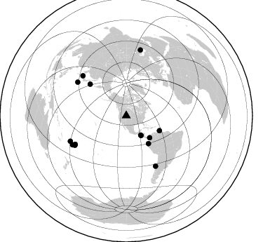
Nearby stations (2 deg radius)
| Station | Name | (Lat, Lon) | Start / End | Elevation |
| Y32 | Y32 | (43.58, -109.45) | 2000-07-06 / 2001-12-31 | 2138 m |
| Crust2 Type: | Q0,orogen/46km no ice, Rockies, Tarim Basin, 4 km seds. |
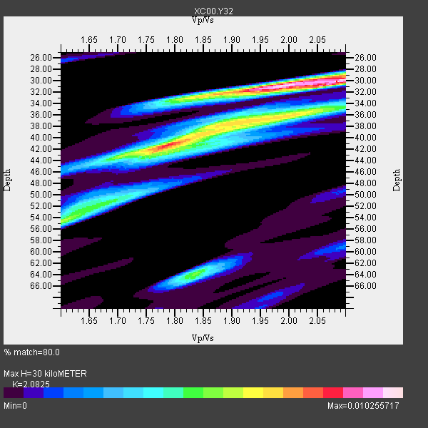
| Thickness Estimate: | 30 km |
| Thickness StdDev: | 11 km |
| Vp/Vs Estimate: | 2.08 |
| Vp/Vs StdDev: | 0.14 |
| Vs Estimate: | 2.958 km/s |
| Poisson's Ratio: | 0.35 |
| Peak Value: | 0.01 |
| Assumed Vp: | 6.161 km/s |
| Ps Weight: | 0.33333334 |
| PpPs Weight: | 0.33333334 |
| PsPs Weight: | 0.33333328 |
| Residual Complexity: | 0.760 |
| Nearby stations H: | +- |
| (2.0 deg) Vp/Vs: | +- |
5 with match > 90% ( 35.714287 %) and 14 with match > 80% ( 100.0 %) out of 14.
Download stack as xyz text file.
Azimuth Distribution of Events:
Prior Results for this Station
| Study | Thickness | Vp/Vs | Vp | Vs | Poissons Ratio | Extra |
| EARS | 30 km | 2.08 | 6.161 km/s | 2.958 km/s | 0.35 | |
| Crust2.0 | 46 km | 1.75 | 6.161 km/s | 3.511 km/s | 0.26 | Q0,orogen/46km no ice, Rockies, Tarim Basin, 4 km seds. |
| Global Maxima | 30 km | 2.08 | 6.161 km/s | 2.958 km/s | 0.35 | amp=0.010255717 |
| Local Maxima 1 | 41 km | 1.79 | 6.161 km/s | 3.451 km/s | 0.27 | amp=0.008275255 |
| Local Maxima 2 | 36 km | 2.00 | 6.161 km/s | 3.077 km/s | 0.33 | amp=0.006388846 |
| Local Maxima 3 | 32 km | 1.93 | 6.161 km/s | 3.188 km/s | 0.32 | amp=0.005349564 |
| Local Maxima 4 | 64 km | 1.84 | 6.161 km/s | 3.357 km/s | 0.29 | amp=0.005249585 |
| Predicted Arrivals for vertical incidence (zero ray parameter) | |
| Ps | 5.27 SECOND |
| PpPs | 15.01 SECOND |
| PsPs/PpSs | 20.28 SECOND |
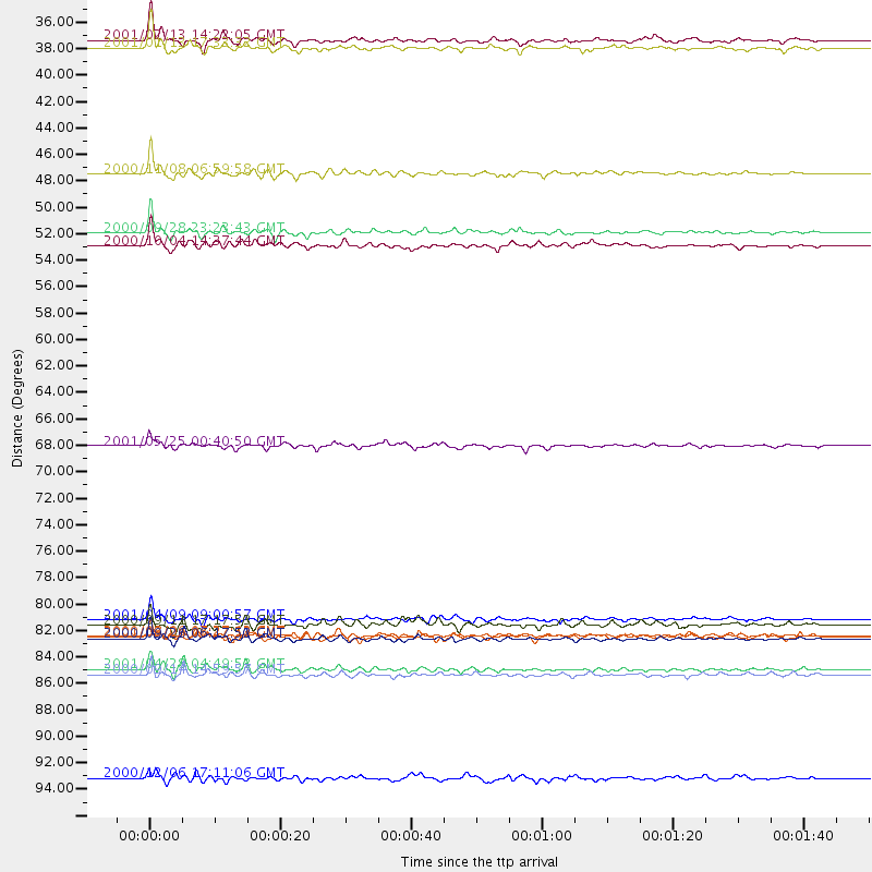
Events Processed for this Station
Download zip of receiver functions as SAC
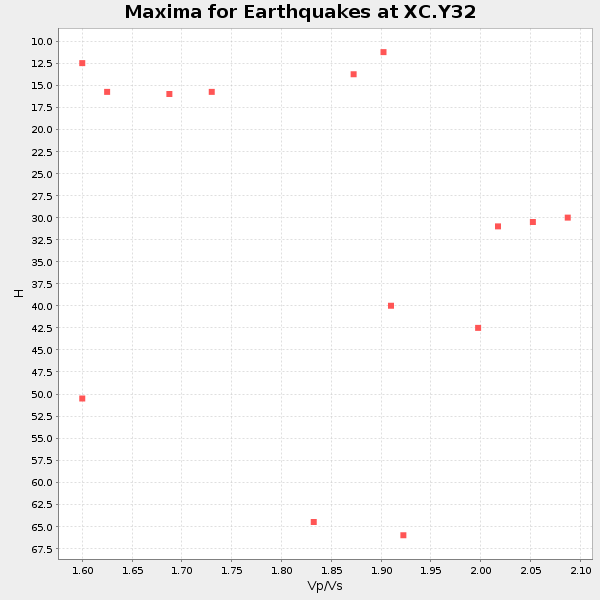
Plot maxima for each earthquake.
Events Used in the Stack
(14 events)| Radial Match | Distance | Baz | FERegion | Time | Lat/Lon | Depth | Magnitude |
| 93.904594 | 35.3 deg | 143.224 deg | El Salvador | 2001/01/13 17:33:32 GMT | (13.0, -88.7) | 60 km | 6.4 MB, 7.8 MS, 7.7 MW, 7.5 ME |
| 93.44856 | 45.7 deg | 133.397 deg | Panama-Colombia Border Region | 2000/11/08 06:59:58 GMT | (7.0, -77.8) | 17 km | 6.0 MB, 6.4 MS, 6.5 MW, 6.2 ML |
| 93.39587 | 51.8 deg | 114.16 deg | Windward Islands | 2000/10/04 14:37:44 GMT | (11.1, -62.6) | 110 km | 5.6 MB, 5.4 MS, 6.1 MW, 5.9 MD |
| 93.17532 | 50.7 deg | 141.376 deg | Near Coast Of Ecuador | 2000/09/28 23:23:43 GMT | (-0.2, -80.6) | 23 km | 5.8 MB, 6.0 MS, 6.6 MW, 6.4 MW |
| 92.63794 | 82.8 deg | 149.75 deg | Off Coast Of Central Chile | 2001/04/09 09:00:57 GMT | (-32.7, -73.1) | 11 km | 6.1 MB, 6.3 MS, 6.7 MW, 6.3 ME |
| 89.81549 | 34.6 deg | 143.164 deg | El Salvador | 2001/02/13 14:22:05 GMT | (13.7, -88.9) | 10 km | 5.5 MB, 6.5 MS, 6.6 MW, 6.1 MD |
| 89.75121 | 84.4 deg | 240.089 deg | Tonga Islands | 2000/09/26 06:17:52 GMT | (-17.2, -173.9) | 56 km | 6.1 MB, 6.1 MS, 6.4 MW, 6.1 ME |
| 87.635666 | 68.4 deg | 310.95 deg | Kuril Islands | 2001/05/25 00:40:50 GMT | (44.3, 148.4) | 33 km | 6.1 MB, 6.7 MS, 6.7 MW, 6.6 MW |
| 85.71227 | 96.0 deg | 12.18 deg | Turkmenistan | 2000/12/06 17:11:06 GMT | (39.6, 54.8) | 30 km | 6.7 MB, 7.5 MS, 7.0 MW, 6.9 ME |
| 82.95289 | 83.3 deg | 240.775 deg | Tonga Islands | 2000/09/11 17:17:53 GMT | (-15.9, -173.7) | 115 km | 6.0 MB, 6.3 MW, 6.3 MW |
| 82.67765 | 87.0 deg | 241.649 deg | Fiji Islands Region | 2001/04/28 04:49:53 GMT | (-18.1, -176.9) | 352 km | 6.2 MB, 6.8 MW, 6.8 MW |
| 82.592285 | 84.2 deg | 304.591 deg | Bonin Islands, Japan Region | 2000/08/06 07:27:12 GMT | (28.9, 139.6) | 395 km | 6.3 MB, 7.3 MW, 7.3 MW |
| 82.15279 | 87.4 deg | 245.513 deg | Fiji Islands | 2000/09/14 14:59:57 GMT | (-15.7, 179.8) | 33 km | 5.7 MB, 6.2 MS, 6.3 MW, 6.2 MW |
| 81.81429 | 84.3 deg | 312.58 deg | Western Honshu, Japan | 2001/03/24 06:27:53 GMT | (34.1, 132.5) | 50 km | 6.4 MB, 6.5 MS, 6.8 MW, 6.4 ME |
Losers
(0 events)| Radial Match | Distance | Baz | FERegion | Time | Lat/Lon | Depth | Magnitude | Reason |
