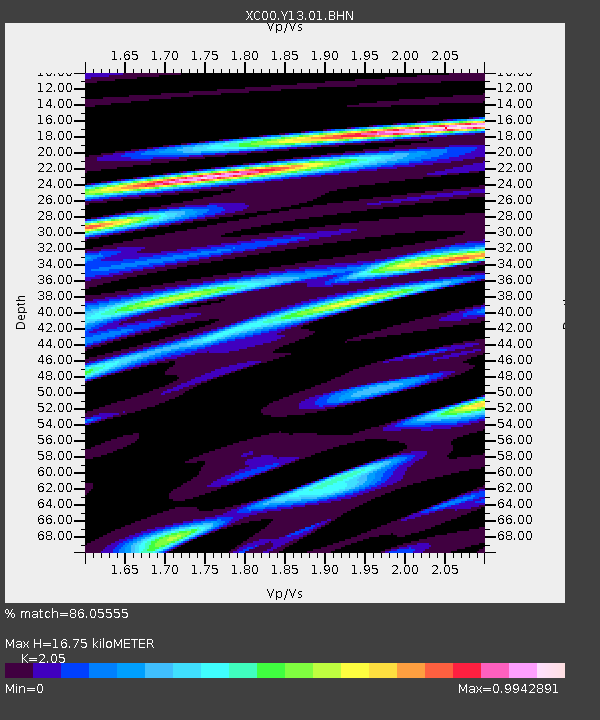
Y13 Y13 - Earthquake Result Viewer
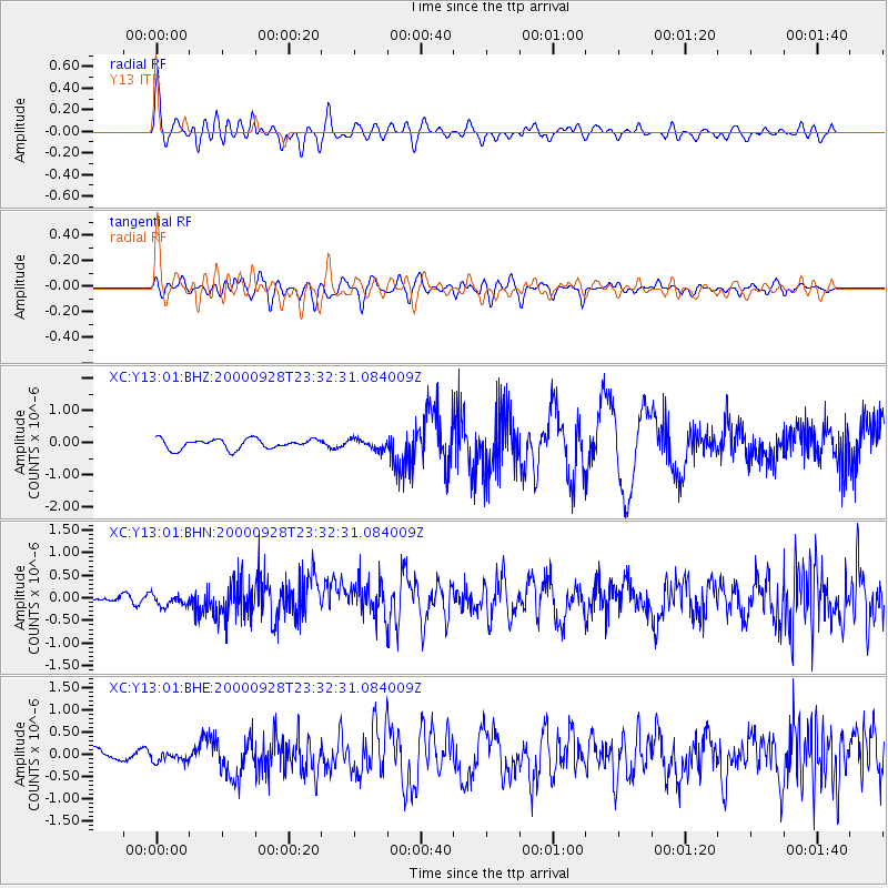
Earthquake location: Near Coast Of Ecuador
Earthquake latitude/longitude: -0.2/-80.6
Earthquake time(UTC): 2000/09/28 (272) 23:23:43 GMT
Earthquake Depth: 23 km
Earthquake Magnitude: 5.8 MB, 6.0 MS, 6.6 MW, 6.4 MW
Earthquake Catalog/Contributor: WHDF/NEIC
Network: XC Yellowstone Intermountain Seismic Array
Station: Y13 Y13
Lat/Lon: 45.27 N/112.82 W
Elevation: 1808 m
Distance: 53.5 deg
Az: 332.062 deg
Baz: 138.434 deg
Ray Param: 0.06601659
Estimated Moho Depth: 16.75 km
Estimated Crust Vp/Vs: 2.05
Assumed Crust Vp: 6.577 km/s
Estimated Crust Vs: 3.208 km/s
Estimated Crust Poisson's Ratio: 0.34
Radial Match: 86.05555 %
Radial Bump: 400
Transverse Match: 69.382355 %
Transverse Bump: 400
SOD ConfigId: 16820
Insert Time: 2010-02-26 14:59:07.827 +0000
GWidth: 2.5
Max Bumps: 400
Tol: 0.001

Signal To Noise

ChannelStoNSTALTA
XC:Y13:01:BHN:20000928T23:32:31.084009Z1.50182011.3070358E-78.7030116E-8
XC:Y13:01:BHE:20000928T23:32:31.084009Z0.5420879.085617E-81.676044E-7
XC:Y13:01:BHZ:20000928T23:32:31.084009Z1.05164711.6224902E-71.5428087E-7
Arrivals
Ps2.8 SECOND
PpPs7.4 SECOND
PsPs/PpSs10 SECOND