
Station XC Y13 - Y13
Network: XC00 - Yellowstone Intermountain Seismic Array
Nearby stations (2 deg radius)
| Station | Name | (Lat, Lon) | Start / End | Elevation |
| Y13 | Y13 | (45.27, -112.82) | 2000-07-13 / 2001-12-31 | 1808 m |
| Crust2 Type: | H3,early/mid Proter. shield, Finland, 0.5 km seds. |
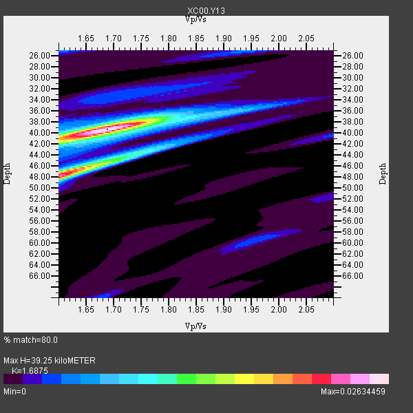
| Thickness Estimate: | 39 km |
| Thickness StdDev: | 4.1 km |
| Vp/Vs Estimate: | 1.69 |
| Vp/Vs StdDev: | 0.04 |
| Vs Estimate: | 3.897 km/s |
| Poisson's Ratio: | 0.23 |
| Peak Value: | 0.03 |
| Assumed Vp: | 6.577 km/s |
| Ps Weight: | 0.33333334 |
| PpPs Weight: | 0.33333334 |
| PsPs Weight: | 0.33333328 |
| Residual Complexity: | 0.532 |
| Nearby stations H: | +- |
| (2.0 deg) Vp/Vs: | +- |
3 with match > 90% ( 21.428572 %) and 14 with match > 80% ( 100.0 %) out of 14.
Download stack as xyz text file.
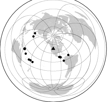
Azimuth Distribution of Events:
Prior Results for this Station
| Study | Thickness | Vp/Vs | Vp | Vs | Poissons Ratio | Extra |
| EARS | 39 km | 1.69 | 6.577 km/s | 3.897 km/s | 0.23 | |
| Crust2.0 | 46 km | 1.78 | 6.577 km/s | 3.701 km/s | 0.27 | H3,early/mid Proter. shield, Finland, 0.5 km seds. |
| Global Maxima | 39 km | 1.69 | 6.577 km/s | 3.897 km/s | 0.23 | amp=0.02634459 |
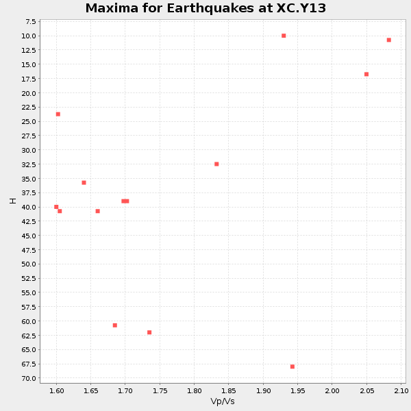
| Local Maxima 1 | 48 km | 1.60 | 6.577 km/s | 4.111 km/s | 0.18 | amp=0.022895543 |
| Local Maxima 2 | 44 km | 1.75 | 6.577 km/s | 3.769 km/s | 0.26 | amp=0.008856032 |
| Local Maxima 3 | 41 km | 1.60 | 6.577 km/s | 4.111 km/s | 0.18 | amp=0.0058038137 |
| Local Maxima 4 | 25 km | 1.60 | 6.577 km/s | 4.111 km/s | 0.18 | amp=0.0045637246 |
| Predicted Arrivals for vertical incidence (zero ray parameter) | |
| Ps | 4.10 SECOND |
| PpPs | 16.04 SECOND |
| PsPs/PpSs | 20.14 SECOND |
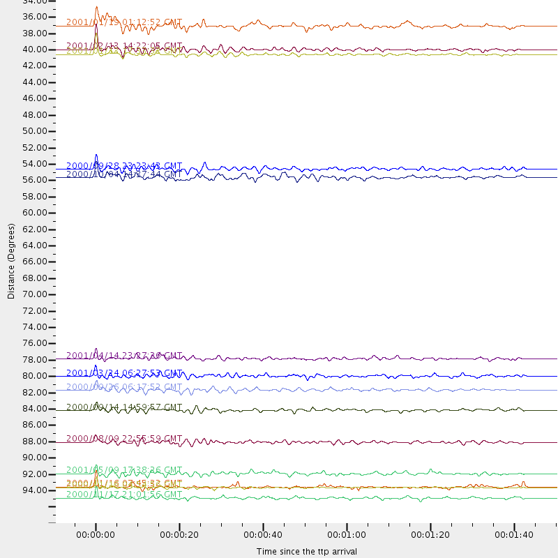
Events Processed for this Station
Download zip of receiver functions as SAC
Plot maxima for each earthquake.
Events Used in the Stack
(14 events)| Radial Match | Distance | Baz | FERegion | Time | Lat/Lon | Depth | Magnitude |
| 95.766136 | 38.1 deg | 139.751 deg | El Salvador | 2001/01/13 17:33:32 GMT | (13.0, -88.7) | 60 km | 6.4 MB, 7.8 MS, 7.7 MW, 7.5 ME |
| 92.48002 | 83.2 deg | 237.445 deg | Tonga Islands | 2000/09/26 06:17:52 GMT | (-17.2, -173.9) | 56 km | 6.1 MB, 6.1 MS, 6.4 MW, 6.1 ME |
| 91.90363 | 37.4 deg | 139.667 deg | El Salvador | 2001/02/13 14:22:05 GMT | (13.7, -88.9) | 10 km | 5.5 MB, 6.5 MS, 6.6 MW, 6.1 MD |
| 88.60976 | 97.7 deg | 269.95 deg | New Britain Region, P.N.G. | 2000/11/17 21:01:56 GMT | (-5.5, 151.8) | 33 km | 6.2 MB, 8.0 MS, 7.6 MW, 6.9 ME |
| 88.53076 | 96.3 deg | 270.751 deg | New Ireland Region, P.N.G. | 2000/11/16 04:54:56 GMT | (-4.0, 152.2) | 33 km | 6.0 MB, 8.2 MS, 8.0 MW, 8.0 ME |
| 86.494225 | 81.3 deg | 310.271 deg | Western Honshu, Japan | 2001/03/24 06:27:53 GMT | (34.1, 132.5) | 50 km | 6.4 MB, 6.5 MS, 6.8 MW, 6.4 ME |
| 86.05555 | 53.5 deg | 138.434 deg | Near Coast Of Ecuador | 2000/09/28 23:23:43 GMT | (-0.2, -80.6) | 23 km | 5.8 MB, 6.0 MS, 6.6 MW, 6.4 MW |
| 85.7126 | 94.4 deg | 259.898 deg | Solomon Islands | 2001/05/09 17:38:26 GMT | (-10.3, 161.2) | 68 km | 6.0 MB, 5.9 MS, 6.3 MW, 6.2 MW |
| 83.71412 | 34.3 deg | 143.923 deg | Mexico-Guatemala Border Region | 2001/01/19 01:12:52 GMT | (15.4, -92.7) | 93 km | 5.4 MB, 5.6 MD |
| 82.958855 | 54.6 deg | 112.26 deg | Windward Islands | 2000/10/04 14:37:44 GMT | (11.1, -62.6) | 110 km | 5.6 MB, 5.4 MS, 6.1 MW, 5.9 MD |
| 82.92431 | 85.9 deg | 243.013 deg | Fiji Islands | 2000/09/14 14:59:57 GMT | (-15.7, 179.8) | 33 km | 5.7 MB, 6.2 MS, 6.3 MW, 6.2 MW |
| 82.48714 | 90.2 deg | 246.245 deg | Fiji Islands Region | 2000/08/09 22:55:59 GMT | (-16.8, 174.3) | 33 km | 5.7 MB, 6.3 MS, 6.4 MW, 6.4 MW |
| 81.36453 | 96.2 deg | 269.403 deg | New Ireland Region, P.N.G. | 2000/11/16 07:45:32 GMT | (-4.8, 153.2) | 33 km | 6.5 MB, 7.2 MS |
| 80.66618 | 79.0 deg | 301.668 deg | Southeast Of Honshu, Japan | 2001/04/14 23:27:26 GMT | (30.1, 141.8) | 10 km | 6.0 MB, 5.8 MS, 6.0 MW, 6.0 ME |
Losers
(0 events)| Radial Match | Distance | Baz | FERegion | Time | Lat/Lon | Depth | Magnitude | Reason |
