You are here: Home > Network List > XC00 - Yellowstone Intermountain Seismic Array Stations List
> Station Y13 Y13 > Earthquake Result Viewer
Y13 Y13 - Earthquake Result Viewer

| Earthquake location: |
New Ireland Region, P.N.G. |
| Earthquake latitude/longitude: |
-4.8/153.2 |
| Earthquake time(UTC): |
2000/11/16 (321) 07:45:32 GMT |
| Earthquake Depth: |
33 km |
| Earthquake Magnitude: |
6.5 MB, 7.2 MS |
| Earthquake Catalog/Contributor: |
WHDF/NEIC |
|
| Network: |
XC Yellowstone Intermountain Seismic Array |
| Station: |
Y13 Y13 |
| Lat/Lon: |
45.27 N/112.82 W |
| Elevation: |
1808 m |
|
| Distance: |
96.2 deg |
| Az: |
45.12 deg |
| Baz: |
269.403 deg |
| Ray Param: |
0.04056998 |
| Estimated Moho Depth: |
23.75 km |
| Estimated Crust Vp/Vs: |
1.60 |
| Assumed Crust Vp: |
6.577 km/s |
| Estimated Crust Vs: |
4.104 km/s |
| Estimated Crust Poisson's Ratio: |
0.18 |
|
| Radial Match: |
81.36453 % |
| Radial Bump: |
329 |
| Transverse Match: |
67.08161 % |
| Transverse Bump: |
366 |
| SOD ConfigId: |
3744 |
| Insert Time: |
2010-02-26 14:59:08.967 +0000 |
| GWidth: |
2.5 |
| Max Bumps: |
400 |
| Tol: |
0.001 |
|
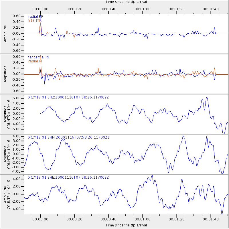
Signal To Noise
| Channel | StoN | STA | LTA |
| XC:Y13:01:BHN:20001116T07:58:26.117002Z | 0.7033054 | 2.1184464E-6 | 3.0121284E-6 |
| XC:Y13:01:BHE:20001116T07:58:26.117002Z | 1.4336349 | 1.2284197E-6 | 8.5685673E-7 |
| XC:Y13:01:BHZ:20001116T07:58:26.117002Z | 1.2738783 | 2.4169149E-6 | 1.8972887E-6 |
| Arrivals |
| Ps | 2.2 SECOND |
| PpPs | 9.2 SECOND |
| PsPs/PpSs | 11 SECOND |


