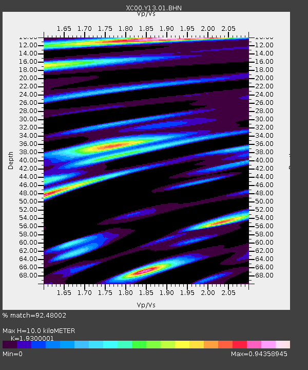
Y13 Y13 - Earthquake Result Viewer

Earthquake location: Tonga Islands
Earthquake latitude/longitude: -17.2/-173.9
Earthquake time(UTC): 2000/09/26 (270) 06:17:52 GMT
Earthquake Depth: 56 km
Earthquake Magnitude: 6.1 MB, 6.1 MS, 6.4 MW, 6.1 ME
Earthquake Catalog/Contributor: WHDF/NEIC
Network: XC Yellowstone Intermountain Seismic Array
Station: Y13 Y13
Lat/Lon: 45.27 N/112.82 W
Elevation: 1808 m
Distance: 83.2 deg
Az: 38.508 deg
Baz: 237.445 deg
Ray Param: 0.0462512
Estimated Moho Depth: 10.0 km
Estimated Crust Vp/Vs: 1.93
Assumed Crust Vp: 6.577 km/s
Estimated Crust Vs: 3.408 km/s
Estimated Crust Poisson's Ratio: 0.32
Radial Match: 92.48002 %
Radial Bump: 400
Transverse Match: 87.978355 %
Transverse Bump: 400
SOD ConfigId: 16820
Insert Time: 2010-02-26 14:59:15.817 +0000
GWidth: 2.5
Max Bumps: 400
Tol: 0.001

Signal To Noise

ChannelStoNSTALTA
XC:Y13:01:BHN:20000926T06:29:41.584011Z4.91915375.216796E-71.06050685E-7
XC:Y13:01:BHE:20000926T06:29:41.584011Z4.54766273.885481E-78.543907E-8
XC:Y13:01:BHZ:20000926T06:29:41.584011Z15.5229561.7162708E-61.10563406E-7
Arrivals
Ps1.4 SECOND
PpPs4.3 SECOND
PsPs/PpSs5.8 SECOND