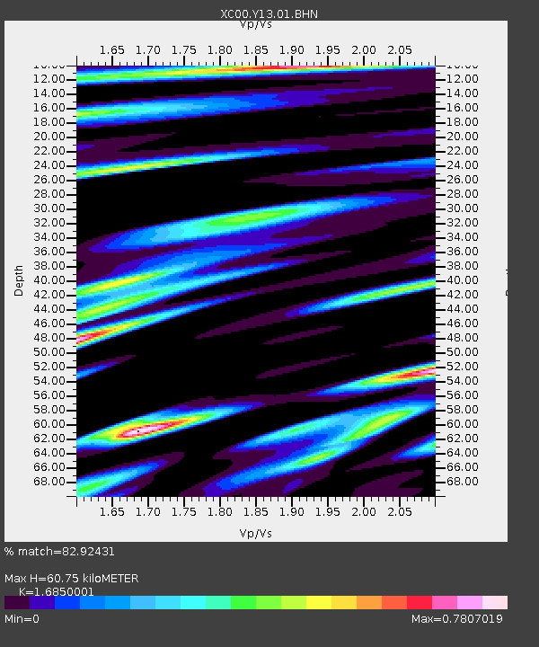
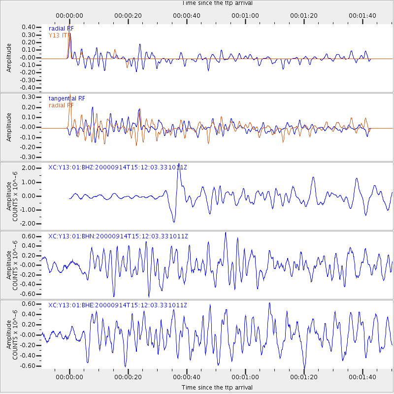
Y13 Y13 - Earthquake Result Viewer

Earthquake location: Fiji Islands
Earthquake latitude/longitude: -15.7/179.8
Earthquake time(UTC): 2000/09/14 (258) 14:59:57 GMT
Earthquake Depth: 33 km
Earthquake Magnitude: 5.7 MB, 6.2 MS, 6.3 MW, 6.2 MW
Earthquake Catalog/Contributor: WHDF/NEIC
Network: XC Yellowstone Intermountain Seismic Array
Station: Y13 Y13
Lat/Lon: 45.27 N/112.82 W
Elevation: 1808 m
Distance: 85.9 deg
Az: 40.803 deg
Baz: 243.013 deg
Ray Param: 0.044356324
Estimated Moho Depth: 60.75 km
Estimated Crust Vp/Vs: 1.69
Assumed Crust Vp: 6.577 km/s
Estimated Crust Vs: 3.903 km/s
Estimated Crust Poisson's Ratio: 0.23
Radial Match: 82.92431 %
Radial Bump: 400
Transverse Match: 73.19058 %
Transverse Bump: 400
SOD ConfigId: 16820
Insert Time: 2010-02-26 14:59:16.768 +0000
GWidth: 2.5
Max Bumps: 400
Tol: 0.001

Signal To Noise

ChannelStoNSTALTA
XC:Y13:01:BHN:20000914T15:12:03.331011Z0.55880868.9587026E-81.603179E-7
XC:Y13:01:BHE:20000914T15:12:03.331011Z0.783228758.594594E-81.0973288E-7
XC:Y13:01:BHZ:20000914T15:12:03.331011Z3.4436783.9111404E-71.13574515E-7
Arrivals
Ps6.5 SECOND
PpPs24 SECOND
PsPs/PpSs31 SECOND