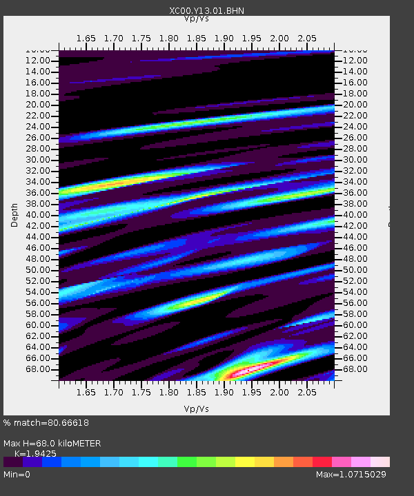
Y13 Y13 - Earthquake Result Viewer
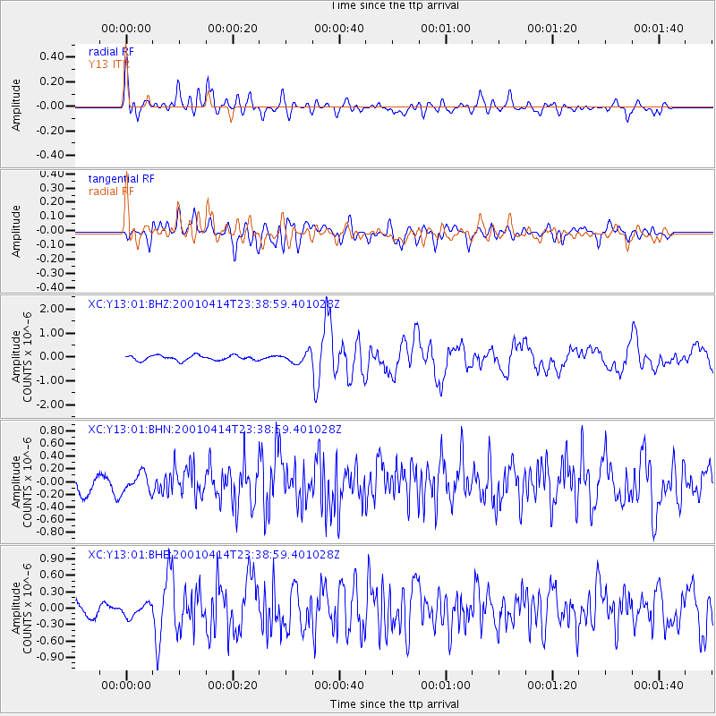
Earthquake location: Southeast Of Honshu, Japan
Earthquake latitude/longitude: 30.1/141.8
Earthquake time(UTC): 2001/04/14 (104) 23:27:26 GMT
Earthquake Depth: 10 km
Earthquake Magnitude: 6.0 MB, 5.8 MS, 6.0 MW, 6.0 ME
Earthquake Catalog/Contributor: WHDF/NEIC
Network: XC Yellowstone Intermountain Seismic Array
Station: Y13 Y13
Lat/Lon: 45.27 N/112.82 W
Elevation: 1808 m
Distance: 79.0 deg
Az: 43.905 deg
Baz: 301.668 deg
Ray Param: 0.049251903
Estimated Moho Depth: 68.0 km
Estimated Crust Vp/Vs: 1.94
Assumed Crust Vp: 6.577 km/s
Estimated Crust Vs: 3.386 km/s
Estimated Crust Poisson's Ratio: 0.32
Radial Match: 80.66618 %
Radial Bump: 400
Transverse Match: 74.89745 %
Transverse Bump: 400
SOD ConfigId: 16820
Insert Time: 2010-02-26 14:59:17.695 +0000
GWidth: 2.5
Max Bumps: 400
Tol: 0.001

Signal To Noise

ChannelStoNSTALTA
XC:Y13:01:BHN:20010414T23:38:59.401028Z1.11137381.4316593E-71.2881888E-7
XC:Y13:01:BHE:20010414T23:38:59.401028Z1.0332831.1668333E-71.1292486E-7
XC:Y13:01:BHZ:20010414T23:38:59.401028Z2.10995722.1655812E-71.0263626E-7
Arrivals
Ps10 SECOND
PpPs30 SECOND
PsPs/PpSs40 SECOND