You are here: Home > Network List > SP - South Carolina Earth Physics Project Stations List
> Station BLACK Blackville-Hilda High School, Barnwell County, SC USA > Earthquake Result Viewer
BLACK Blackville-Hilda High School, Barnwell County, SC USA - Earthquake Result Viewer
| Earthquake location: |
Chile-Bolivia Border Region |
| Earthquake latitude/longitude: |
-21.7/-68.3 |
| Earthquake time(UTC): |
2002/03/28 (087) 04:56:22 GMT |
| Earthquake Depth: |
125 km |
| Earthquake Magnitude: |
6.1 MB, 6.5 MW, 6.5 MW |
| Earthquake Catalog/Contributor: |
WHDF/NEIC |
|
| Network: |
SP South Carolina Earth Physics Project |
| Station: |
BLACK Blackville-Hilda High School, Barnwell County, SC USA |
| Lat/Lon: |
33.36 N/81.26 W |
| Elevation: |
94 m |
|
| Distance: |
56.1 deg |
| Az: |
346.956 deg |
| Baz: |
165.471 deg |
| Ray Param: |
0.06397498 |
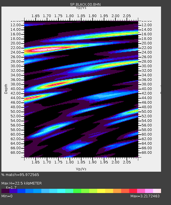
| Estimated Moho Depth: |
22.5 km |
| Estimated Crust Vp/Vs: |
1.70 |
| Assumed Crust Vp: |
6.565 km/s |
| Estimated Crust Vs: |
3.861 km/s |
| Estimated Crust Poisson's Ratio: |
0.24 |
|
| Radial Match: |
95.972565 % |
| Radial Bump: |
400 |
| Transverse Match: |
89.19344 % |
| Transverse Bump: |
400 |
| SOD ConfigId: |
2217 |
| Insert Time: |
2010-02-25 16:35:36.411 +0000 |
| GWidth: |
2.5 |
| Max Bumps: |
400 |
| Tol: |
0.001 |
|
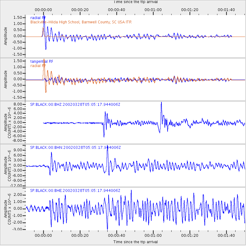
Signal To Noise
| Channel | StoN | STA | LTA |
| SP:BLACK:00:BHN:20020328T05:05:17.944006Z | 9.959927 | 2.6133162E-6 | 2.6238305E-7 |
| SP:BLACK:00:BHE:20020328T05:05:17.944006Z | 2.957577 | 7.572606E-7 | 2.5604086E-7 |
| SP:BLACK:00:BHZ:20020328T05:05:17.944006Z | 22.02086 | 2.1992935E-6 | 9.987318E-8 |
| Arrivals |
| Ps | 2.5 SECOND |
| PpPs | 8.8 SECOND |
| PsPs/PpSs | 11 SECOND |


