
Station SP BLACK - Blackville-Hilda High School, Barnwell County, SC USA
Network: SP - South Carolina Earth Physics Project
Nearby stations (2 deg radius)
| Station | Name | (Lat, Lon) | Start / End | Elevation |
| BLACK | Blackville-Hilda High School, Barnwell County, SC USA | (33.36, -81.26) | 2002-02-15 / 2499-01-01 | 94 m |
| Crust2 Type: | DG,thin Platform 1 km seds. |
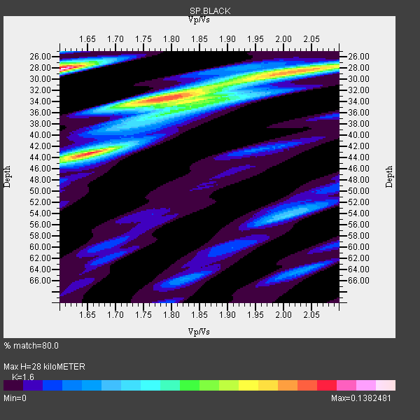
| Thickness Estimate: | 28 km |
| Thickness StdDev: | 6.4 km |
| Vp/Vs Estimate: | 1.60 |
| Vp/Vs StdDev: | 0.12 |
| Vs Estimate: | 4.103 km/s |
| Poisson's Ratio: | 0.18 |
| Peak Value: | 0.14 |
| Assumed Vp: | 6.565 km/s |
| Ps Weight: | 0.33333334 |
| PpPs Weight: | 0.33333334 |
| PsPs Weight: | 0.33333328 |
| Residual Complexity: | 0.953 |
| Nearby stations H: | +- |
| (2.0 deg) Vp/Vs: | +- |
6 with match > 90% ( 54.545456 %) and 11 with match > 80% ( 100.0 %) out of 11.
Download stack as xyz text file.
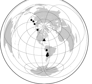
Azimuth Distribution of Events:
Prior Results for this Station
| Study | Thickness | Vp/Vs | Vp | Vs | Poissons Ratio | Extra |
| EARS | 28 km | 1.60 | 6.565 km/s | 4.103 km/s | 0.18 | |
| Crust2.0 | 31 km | 1.78 | 6.565 km/s | 3.684 km/s | 0.27 | DG,thin Platform 1 km seds. |
| Global Maxima | 28 km | 1.60 | 6.565 km/s | 4.103 km/s | 0.18 | amp=0.1382481 |
| Local Maxima 1 | 43 km | 1.65 | 6.565 km/s | 3.985 km/s | 0.21 | amp=0.113457926 |
| Local Maxima 2 | 33 km | 1.79 | 6.565 km/s | 3.678 km/s | 0.27 | amp=0.108738 |
| Local Maxima 3 | 28 km | 2.02 | 6.565 km/s | 3.25 km/s | 0.34 | amp=0.09787646 |
| Local Maxima 4 | 34 km | 1.83 | 6.565 km/s | 3.587 km/s | 0.29 | amp=0.047538593 |
| Predicted Arrivals for vertical incidence (zero ray parameter) | |
| Ps | 2.56 SECOND |
| PpPs | 11.09 SECOND |
| PsPs/PpSs | 13.65 SECOND |
Events Processed for this Station
Download zip of receiver functions as SAC
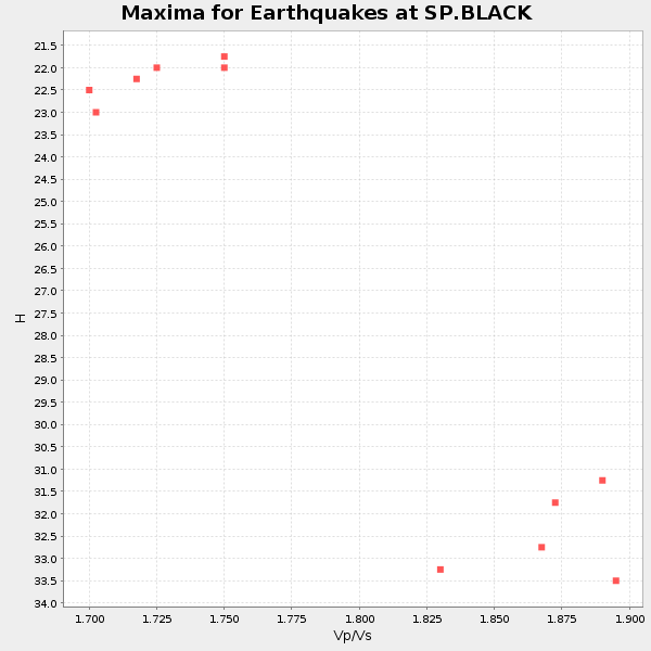
Plot maxima for each earthquake.
Events Used in the Stack
(11 events)| Radial Match | Distance | Baz | FERegion | Time | Lat/Lon | Depth | Magnitude |
| 96.49696 | 50.1 deg | 327.707 deg | Central Alaska | 2002/11/03 22:12:41 GMT | (63.5, -147.4) | 4.9 km | 7.0 MB, 8.5 MS, 7.9 MW |
| 95.972565 | 56.1 deg | 165.471 deg | Chile-Bolivia Border Region | 2002/03/28 04:56:22 GMT | (-21.7, -68.3) | 125 km | 6.1 MB, 6.5 MW, 6.5 MW |
| 94.27571 | 77.2 deg | 329.225 deg | Kamchatka Peninsula, Russia | 2003/06/16 22:08:02 GMT | (55.5, 160.0) | 175 km | 6.3 MB, 6.9 MW, 6.9 MW |
| 94.17522 | 61.4 deg | 169.2 deg | Near Coast Of Northern Chile | 2002/04/18 16:08:36 GMT | (-27.5, -70.6) | 62 km | 6.2 MB, 6.7 MW, 6.6 MW |
| 93.61544 | 42.4 deg | 165.945 deg | Western Brazil | 2002/10/12 20:09:11 GMT | (-8.3, -71.7) | 534 km | 6.5 MB, 6.9 MW, 6.9 MW |
| 92.483925 | 64.5 deg | 170.342 deg | Near Coast Of Central Chile | 2002/06/18 13:56:22 GMT | (-30.8, -71.1) | 54 km | 6.0 MB, 6.6 MW, 6.4 MW |
| 89.21491 | 65.5 deg | 168.691 deg | San Juan Province, Argentina | 2002/09/24 03:57:22 GMT | (-31.5, -69.2) | 120 km | 6.2 MB, 6.4 MW, 6.3 MW |
| 88.06119 | 88.7 deg | 330.214 deg | Northwest Of Kuril Islands | 2002/11/17 04:53:53 GMT | (47.8, 146.2) | 459 km | 7.3 MW, 7.3 MW |
| 87.87495 | 63.5 deg | 165.833 deg | Catamarca Province, Argentina | 2002/05/28 04:04:22 GMT | (-28.9, -66.8) | 22 km | 6.0 MB, 5.7 MS, 6.0 MW, 5.9 MW |
| 86.16598 | 97.9 deg | 327.593 deg | Near East Coast Of Honshu, Japan | 2003/05/26 09:24:33 GMT | (38.8, 141.6) | 68 km | 6.7 MB, 7.0 MW, 7.0 MW |
| 82.31803 | 41.7 deg | 165.711 deg | Western Brazil | 2003/06/20 06:19:38 GMT | (-7.6, -71.7) | 558 km | 6.4 MB, 7.1 MW, 7.0 MW |
Losers
(0 events)| Radial Match | Distance | Baz | FERegion | Time | Lat/Lon | Depth | Magnitude | Reason |
