You are here: Home > Network List > XC00 - Yellowstone Intermountain Seismic Array Stations List
> Station Y13 Y13 > Earthquake Result Viewer
Y13 Y13 - Earthquake Result Viewer
| Earthquake location: |
Mexico-Guatemala Border Region |
| Earthquake latitude/longitude: |
15.4/-92.7 |
| Earthquake time(UTC): |
2001/01/19 (019) 01:12:52 GMT |
| Earthquake Depth: |
93 km |
| Earthquake Magnitude: |
5.4 MB, 5.6 MD |
| Earthquake Catalog/Contributor: |
WHDF/NEIC |
|
| Network: |
XC Yellowstone Intermountain Seismic Array |
| Station: |
Y13 Y13 |
| Lat/Lon: |
45.27 N/112.82 W |
| Elevation: |
1808 m |
|
| Distance: |
34.3 deg |
| Az: |
334.461 deg |
| Baz: |
143.923 deg |
| Ray Param: |
0.077547796 |
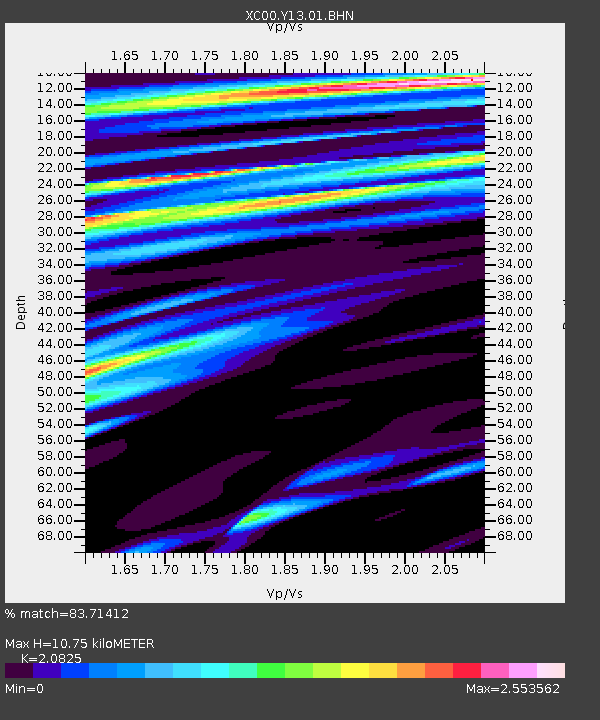
| Estimated Moho Depth: |
10.75 km |
| Estimated Crust Vp/Vs: |
2.08 |
| Assumed Crust Vp: |
6.577 km/s |
| Estimated Crust Vs: |
3.158 km/s |
| Estimated Crust Poisson's Ratio: |
0.35 |
|
| Radial Match: |
83.71412 % |
| Radial Bump: |
400 |
| Transverse Match: |
80.35533 % |
| Transverse Bump: |
400 |
| SOD ConfigId: |
16820 |
| Insert Time: |
2010-02-26 14:59:20.611 +0000 |
| GWidth: |
2.5 |
| Max Bumps: |
400 |
| Tol: |
0.001 |
|

Signal To Noise
| Channel | StoN | STA | LTA |
| XC:Y13:01:BHN:20010119T01:18:58.858015Z | 0.8305575 | 4.866488E-7 | 5.859303E-7 |
| XC:Y13:01:BHE:20010119T01:18:58.858015Z | 1.1948583 | 5.803678E-7 | 4.85721E-7 |
| XC:Y13:01:BHZ:20010119T01:18:58.858015Z | 3.7383225 | 9.98212E-7 | 2.6702136E-7 |
| Arrivals |
| Ps | 1.9 SECOND |
| PpPs | 4.7 SECOND |
| PsPs/PpSs | 6.6 SECOND |


