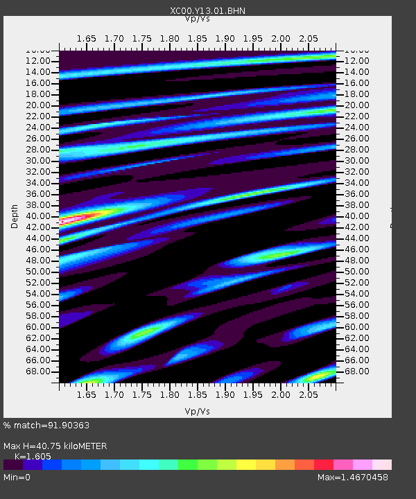
Y13 Y13 - Earthquake Result Viewer
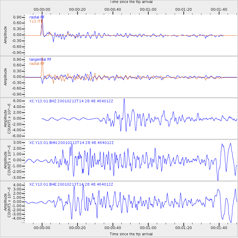
Earthquake location: El Salvador
Earthquake latitude/longitude: 13.7/-88.9
Earthquake time(UTC): 2001/02/13 (044) 14:22:05 GMT
Earthquake Depth: 10 km
Earthquake Magnitude: 5.5 MB, 6.5 MS, 6.6 MW, 6.1 MD
Earthquake Catalog/Contributor: WHDF/NEIC
Network: XC Yellowstone Intermountain Seismic Array
Station: Y13 Y13
Lat/Lon: 45.27 N/112.82 W
Elevation: 1808 m
Distance: 37.4 deg
Az: 331.954 deg
Baz: 139.667 deg
Ray Param: 0.076131284
Estimated Moho Depth: 40.75 km
Estimated Crust Vp/Vs: 1.61
Assumed Crust Vp: 6.577 km/s
Estimated Crust Vs: 4.098 km/s
Estimated Crust Poisson's Ratio: 0.18
Radial Match: 91.90363 %
Radial Bump: 400
Transverse Match: 81.82978 %
Transverse Bump: 400
SOD ConfigId: 3744
Insert Time: 2010-02-26 14:59:22.725 +0000
GWidth: 2.5
Max Bumps: 400
Tol: 0.001

Signal To Noise

ChannelStoNSTALTA
XC:Y13:01:BHN:20010213T14:28:48.464012Z0.78168691.6028721E-72.0505296E-7
XC:Y13:01:BHE:20010213T14:28:48.464012Z0.840790872.578398E-73.066634E-7
XC:Y13:01:BHZ:20010213T14:28:48.464012Z1.38278043.9977172E-72.8910716E-7
Arrivals
Ps4.1 SECOND
PpPs15 SECOND
PsPs/PpSs19 SECOND