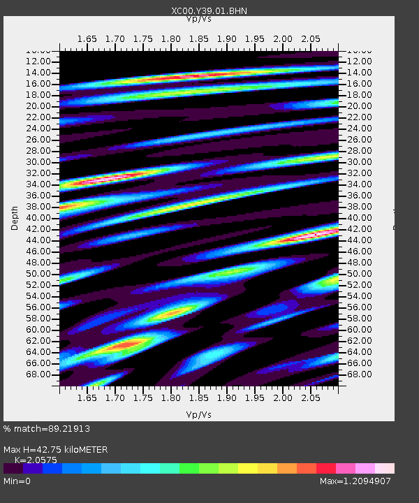
Y39 Y39 - Earthquake Result Viewer
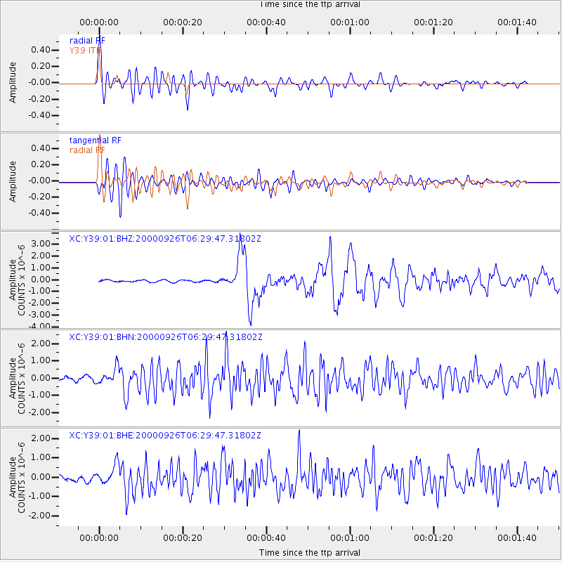
Earthquake location: Tonga Islands
Earthquake latitude/longitude: -17.2/-173.9
Earthquake time(UTC): 2000/09/26 (270) 06:17:52 GMT
Earthquake Depth: 56 km
Earthquake Magnitude: 6.1 MB, 6.1 MS, 6.4 MW, 6.1 ME
Earthquake Catalog/Contributor: WHDF/NEIC
Network: XC Yellowstone Intermountain Seismic Array
Station: Y39 Y39
Lat/Lon: 45.59 N/111.22 W
Elevation: 1517 m
Distance: 84.3 deg
Az: 38.83 deg
Baz: 238.614 deg
Ray Param: 0.045458224
Estimated Moho Depth: 42.75 km
Estimated Crust Vp/Vs: 2.06
Assumed Crust Vp: 6.35 km/s
Estimated Crust Vs: 3.086 km/s
Estimated Crust Poisson's Ratio: 0.35
Radial Match: 89.21913 %
Radial Bump: 400
Transverse Match: 83.74051 %
Transverse Bump: 400
SOD ConfigId: 16820
Insert Time: 2010-02-26 14:59:28.365 +0000
GWidth: 2.5
Max Bumps: 400
Tol: 0.001

Signal To Noise

ChannelStoNSTALTA
XC:Y39:01:BHN:20000926T06:29:47.31802Z4.4037254.6024795E-71.04513326E-7
XC:Y39:01:BHE:20000926T06:29:47.31802Z3.05311134.8932225E-71.6027002E-7
XC:Y39:01:BHZ:20000926T06:29:47.31802Z18.457411.5988895E-68.662588E-8
Arrivals
Ps7.3 SECOND
PpPs20 SECOND
PsPs/PpSs27 SECOND