
Station XC Y39 - Y39
Network: XC00 - Yellowstone Intermountain Seismic Array
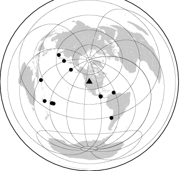
Nearby stations (2 deg radius)
| Station | Name | (Lat, Lon) | Start / End | Elevation |
| Y39 | Y39 | (45.59, -111.22) | 2000-07-08 / 2001-12-31 | 1517 m |
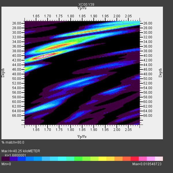
| Crust2 Type: | P6,orogen/43km, Orogen, 0.5 km seds. |
| Thickness Estimate: | 40 km |
| Thickness StdDev: | 5.7 km |
| Vp/Vs Estimate: | 1.68 |
| Vp/Vs StdDev: | 0.11 |
| Vs Estimate: | 3.78 km/s |
| Poisson's Ratio: | 0.23 |
| Peak Value: | 0.02 |
| Assumed Vp: | 6.35 km/s |
| Ps Weight: | 0.33333334 |
| PpPs Weight: | 0.33333334 |
| PsPs Weight: | 0.33333328 |
| Residual Complexity: | 0.754 |
| Nearby stations H: | +- |
| (2.0 deg) Vp/Vs: | +- |
3 with match > 90% ( 25.0 %) and 12 with match > 80% ( 100.0 %) out of 12.
Download stack as xyz text file.
Azimuth Distribution of Events:
Prior Results for this Station
| Study | Thickness | Vp/Vs | Vp | Vs | Poissons Ratio | Extra |
| EARS | 40 km | 1.68 | 6.35 km/s | 3.78 km/s | 0.23 | |
| Crust2.0 | 43 km | 1.76 | 6.35 km/s | 3.609 km/s | 0.26 | P6,orogen/43km, Orogen, 0.5 km seds. |
| Global Maxima | 40 km | 1.68 | 6.35 km/s | 3.78 km/s | 0.23 | amp=0.018548723 |
| Local Maxima 1 | 29 km | 1.88 | 6.35 km/s | 3.369 km/s | 0.30 | amp=0.014256472 |
| Local Maxima 2 | 35 km | 1.77 | 6.35 km/s | 3.588 km/s | 0.27 | amp=0.008694682 |
| Local Maxima 3 | 63 km | 1.66 | 6.35 km/s | 3.814 km/s | 0.22 | amp=0.008536633 |
| Local Maxima 4 | 46 km | 1.60 | 6.35 km/s | 3.969 km/s | 0.18 | amp=0.006914453 |
| Predicted Arrivals for vertical incidence (zero ray parameter) | |
| Ps | 4.31 SECOND |
| PpPs | 16.99 SECOND |
| PsPs/PpSs | 21.30 SECOND |
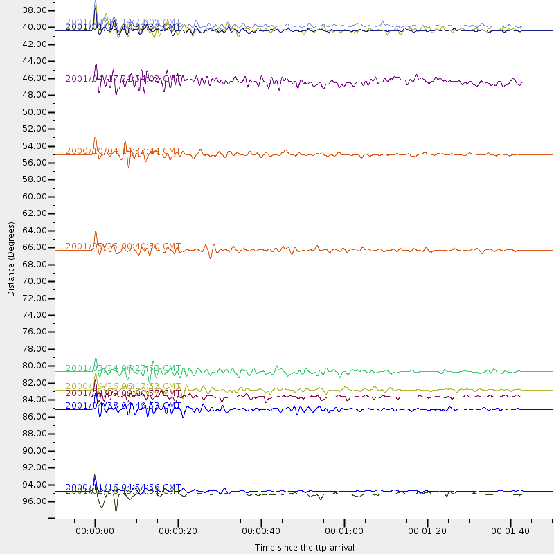
Events Processed for this Station
Download zip of receiver functions as SAC
Plot maxima for each earthquake.
Events Used in the Stack
(12 events)| Radial Match | Distance | Baz | FERegion | Time | Lat/Lon | Depth | Magnitude |
| 93.41566 | 97.9 deg | 246.728 deg | Southeast Of Loyalty Islands | 2001/02/28 13:05:31 GMT | (-22.0, 170.1) | 10 km | 5.8 MB, 6.1 MS, 6.2 MW |
| 92.25416 | 37.0 deg | 142.22 deg | El Salvador | 2001/02/13 14:22:05 GMT | (13.7, -88.9) | 10 km | 5.5 MB, 6.5 MS, 6.6 MW, 6.1 MD |
| 91.73218 | 37.7 deg | 142.27 deg | El Salvador | 2001/01/13 17:33:32 GMT | (13.0, -88.7) | 60 km | 6.4 MB, 7.8 MS, 7.7 MW, 7.5 ME |
| 89.21913 | 84.3 deg | 238.614 deg | Tonga Islands | 2000/09/26 06:17:52 GMT | (-17.2, -173.9) | 56 km | 6.1 MB, 6.1 MS, 6.4 MW, 6.1 ME |
| 88.3416 | 66.1 deg | 309.407 deg | Kuril Islands | 2001/05/25 00:40:50 GMT | (44.3, 148.4) | 33 km | 6.1 MB, 6.7 MS, 6.7 MW, 6.6 MW |
| 88.02604 | 97.5 deg | 271.927 deg | New Ireland Region, P.N.G. | 2000/11/16 04:54:56 GMT | (-4.0, 152.2) | 33 km | 6.0 MB, 8.2 MS, 8.0 MW, 8.0 ME |
| 85.59251 | 53.7 deg | 113.927 deg | Windward Islands | 2000/10/04 14:37:44 GMT | (11.1, -62.6) | 110 km | 5.6 MB, 5.4 MS, 6.1 MW, 5.9 MD |
| 84.8493 | 85.2 deg | 148.505 deg | Off Coast Of Central Chile | 2001/04/09 09:00:57 GMT | (-32.7, -73.1) | 11 km | 6.1 MB, 6.3 MS, 6.7 MW, 6.3 ME |
| 82.73947 | 86.8 deg | 240.28 deg | Fiji Islands Region | 2001/04/28 04:49:53 GMT | (-18.1, -176.9) | 352 km | 6.2 MB, 6.8 MW, 6.8 MW |
| 82.7045 | 44.3 deg | 303.167 deg | Andreanof Islands, Aleutian Is. | 2001/04/17 21:54:02 GMT | (51.2, -179.8) | 33 km | 5.8 MB, 5.5 MS, 6.0 MW, 5.9 ML |
| 81.06202 | 82.0 deg | 311.261 deg | Western Honshu, Japan | 2001/03/24 06:27:53 GMT | (34.1, 132.5) | 50 km | 6.4 MB, 6.5 MS, 6.8 MW, 6.4 ME |
| 80.65845 | 37.6 deg | 142.258 deg | El Salvador | 2001/03/16 00:01:18 GMT | (13.1, -88.7) | 49 km | 5.2 MB, 5.8 MS, 5.9 MW, 5.7 MD |
Losers
(0 events)| Radial Match | Distance | Baz | FERegion | Time | Lat/Lon | Depth | Magnitude | Reason |
