You are here: Home > Network List > XC00 - Yellowstone Intermountain Seismic Array Stations List
> Station Y39 Y39 > Earthquake Result Viewer
Y39 Y39 - Earthquake Result Viewer
| Earthquake location: |
Southeast Of Loyalty Islands |
| Earthquake latitude/longitude: |
-22.0/170.1 |
| Earthquake time(UTC): |
2001/02/28 (059) 13:05:31 GMT |
| Earthquake Depth: |
10 km |
| Earthquake Magnitude: |
5.8 MB, 6.1 MS, 6.2 MW |
| Earthquake Catalog/Contributor: |
WHDF/NEIC |
|
| Network: |
XC Yellowstone Intermountain Seismic Array |
| Station: |
Y39 Y39 |
| Lat/Lon: |
45.59 N/111.22 W |
| Elevation: |
1517 m |
|
| Distance: |
97.9 deg |
| Az: |
44.028 deg |
| Baz: |
246.728 deg |
| Ray Param: |
0.040077034 |
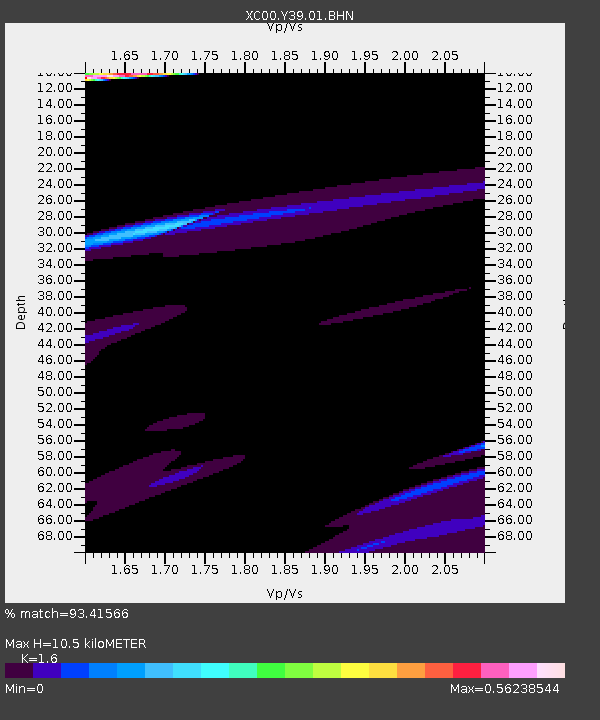
| Estimated Moho Depth: |
10.5 km |
| Estimated Crust Vp/Vs: |
1.60 |
| Assumed Crust Vp: |
6.35 km/s |
| Estimated Crust Vs: |
3.969 km/s |
| Estimated Crust Poisson's Ratio: |
0.18 |
|
| Radial Match: |
93.41566 % |
| Radial Bump: |
400 |
| Transverse Match: |
71.42076 % |
| Transverse Bump: |
400 |
| SOD ConfigId: |
3744 |
| Insert Time: |
2010-02-26 14:59:35.670 +0000 |
| GWidth: |
2.5 |
| Max Bumps: |
400 |
| Tol: |
0.001 |
|

Signal To Noise
| Channel | StoN | STA | LTA |
| XC:Y39:01:BHN:20010228T13:18:35.658005Z | 1.2053014 | 1.7653373E-6 | 1.4646439E-6 |
| XC:Y39:01:BHE:20010228T13:18:35.658005Z | 1.1486892 | 3.4598136E-6 | 3.0119668E-6 |
| XC:Y39:01:BHZ:20010228T13:18:35.658005Z | 1.4209713 | 4.6038435E-6 | 3.239927E-6 |
| Arrivals |
| Ps | 1.0 SECOND |
| PpPs | 4.2 SECOND |
| PsPs/PpSs | 5.2 SECOND |


