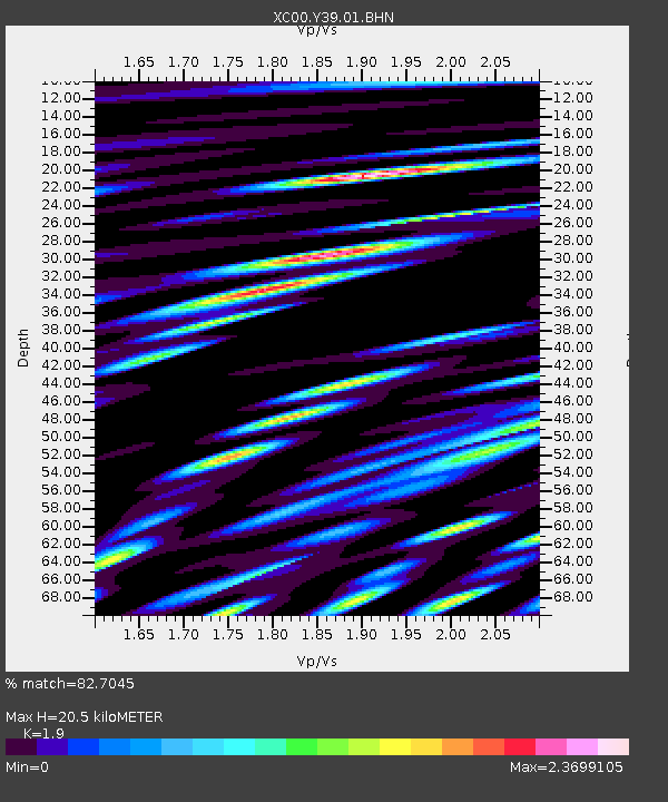
Y39 Y39 - Earthquake Result Viewer
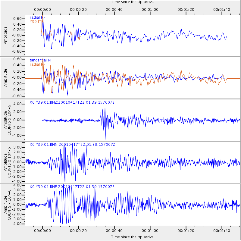
Earthquake location: Andreanof Islands, Aleutian Is.
Earthquake latitude/longitude: 51.2/-179.8
Earthquake time(UTC): 2001/04/17 (107) 21:54:02 GMT
Earthquake Depth: 33 km
Earthquake Magnitude: 5.8 MB, 5.5 MS, 6.0 MW, 5.9 ML
Earthquake Catalog/Contributor: WHDF/NEIC
Network: XC Yellowstone Intermountain Seismic Array
Station: Y39 Y39
Lat/Lon: 45.59 N/111.22 W
Elevation: 1517 m
Distance: 44.3 deg
Az: 69.219 deg
Baz: 303.167 deg
Ray Param: 0.07190893
Estimated Moho Depth: 20.5 km
Estimated Crust Vp/Vs: 1.90
Assumed Crust Vp: 6.35 km/s
Estimated Crust Vs: 3.342 km/s
Estimated Crust Poisson's Ratio: 0.31
Radial Match: 82.7045 %
Radial Bump: 400
Transverse Match: 83.422386 %
Transverse Bump: 400
SOD ConfigId: 4714
Insert Time: 2010-02-26 14:59:36.748 +0000
GWidth: 2.5
Max Bumps: 400
Tol: 0.001

Signal To Noise

ChannelStoNSTALTA
XC:Y39:01:BHN:20010417T22:01:39.157007Z1.36955923.7939515E-72.770199E-7
XC:Y39:01:BHE:20010417T22:01:39.157007Z2.855737.828416E-72.7413012E-7
XC:Y39:01:BHZ:20010417T22:01:39.157007Z5.81693551.0946512E-61.8818348E-7
Arrivals
Ps3.1 SECOND
PpPs8.8 SECOND
PsPs/PpSs12 SECOND