You are here: Home > Network List > XC00 - Yellowstone Intermountain Seismic Array Stations List
> Station Y39 Y39 > Earthquake Result Viewer
Y39 Y39 - Earthquake Result Viewer
| Earthquake location: |
Fiji Islands Region |
| Earthquake latitude/longitude: |
-18.1/-176.9 |
| Earthquake time(UTC): |
2001/04/28 (118) 04:49:53 GMT |
| Earthquake Depth: |
352 km |
| Earthquake Magnitude: |
6.2 MB, 6.8 MW, 6.8 MW |
| Earthquake Catalog/Contributor: |
WHDF/NEIC |
|
| Network: |
XC Yellowstone Intermountain Seismic Array |
| Station: |
Y39 Y39 |
| Lat/Lon: |
45.59 N/111.22 W |
| Elevation: |
1517 m |
|
| Distance: |
86.8 deg |
| Az: |
39.864 deg |
| Baz: |
240.28 deg |
| Ray Param: |
0.042868856 |
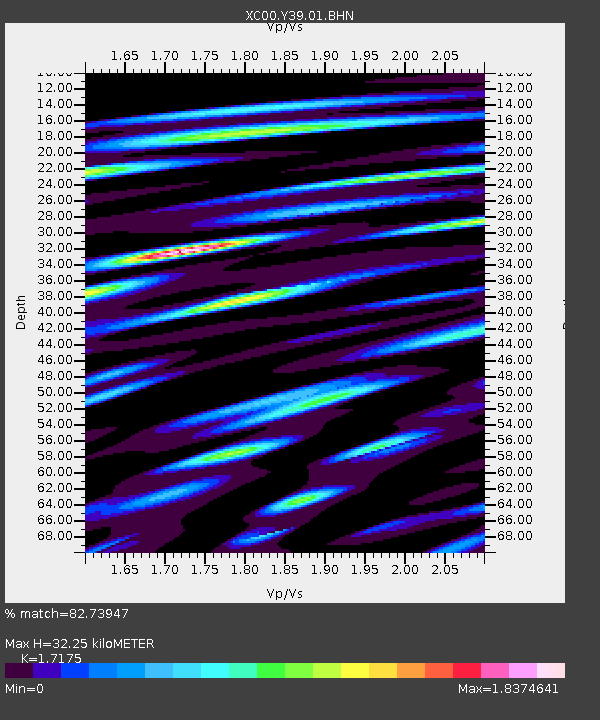
| Estimated Moho Depth: |
32.25 km |
| Estimated Crust Vp/Vs: |
1.72 |
| Assumed Crust Vp: |
6.35 km/s |
| Estimated Crust Vs: |
3.697 km/s |
| Estimated Crust Poisson's Ratio: |
0.24 |
|
| Radial Match: |
82.73947 % |
| Radial Bump: |
400 |
| Transverse Match: |
78.13286 % |
| Transverse Bump: |
400 |
| SOD ConfigId: |
4714 |
| Insert Time: |
2010-02-26 14:59:38.074 +0000 |
| GWidth: |
2.5 |
| Max Bumps: |
400 |
| Tol: |
0.001 |
|
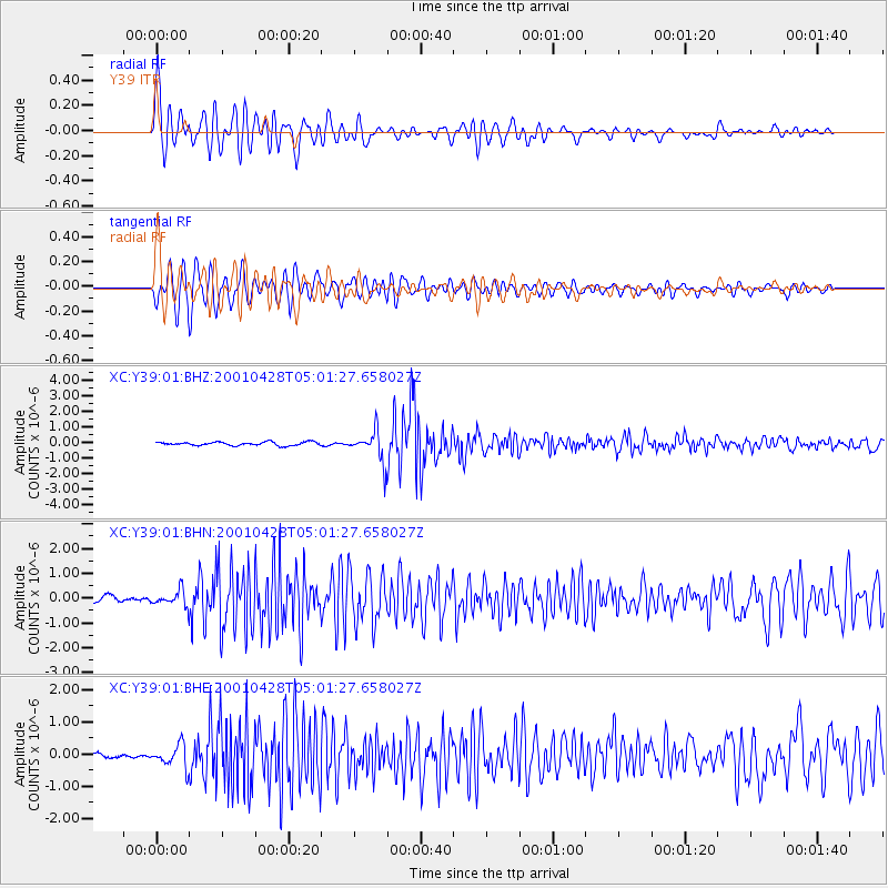
Signal To Noise
| Channel | StoN | STA | LTA |
| XC:Y39:01:BHN:20010428T05:01:27.658027Z | 3.4596188 | 3.2975578E-7 | 9.531564E-8 |
| XC:Y39:01:BHE:20010428T05:01:27.658027Z | 4.0493693 | 3.4086648E-7 | 8.4177664E-8 |
| XC:Y39:01:BHZ:20010428T05:01:27.658027Z | 8.478887 | 9.492083E-7 | 1.11949646E-7 |
| Arrivals |
| Ps | 3.7 SECOND |
| PpPs | 13 SECOND |
| PsPs/PpSs | 17 SECOND |


