Y39 Y39 - Earthquake Result Viewer
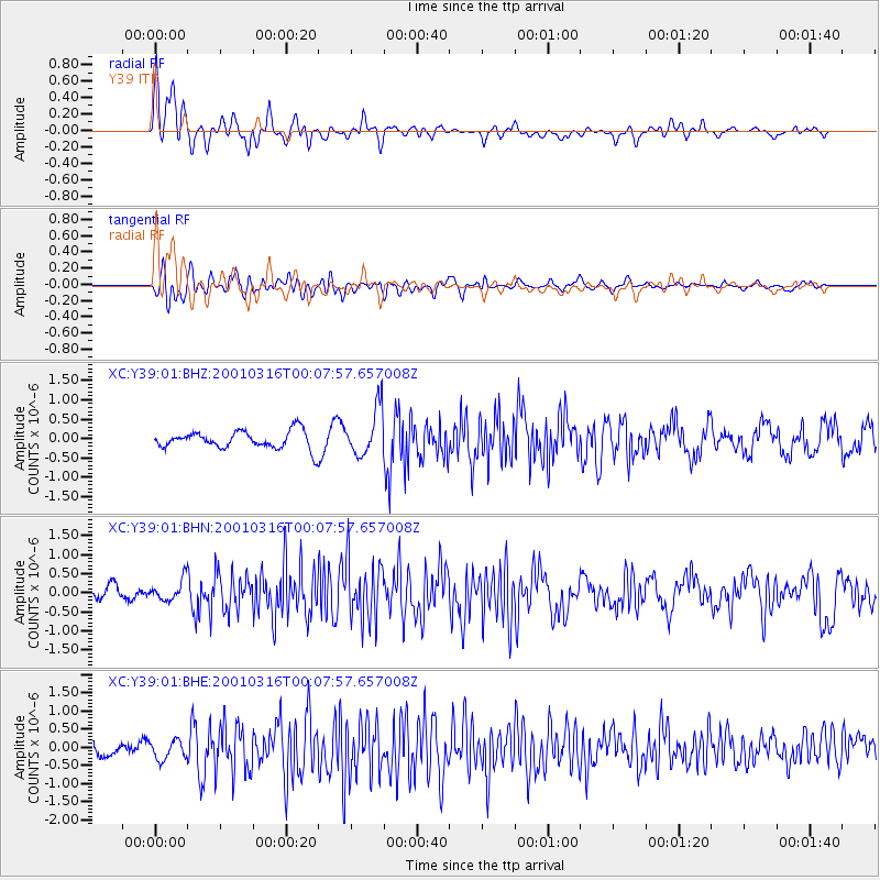
Earthquake location: El Salvador
Earthquake latitude/longitude: 13.1/-88.7
Earthquake time(UTC): 2001/03/16 (075) 00:01:18 GMT
Earthquake Depth: 49 km
Earthquake Magnitude: 5.2 MB, 5.8 MS, 5.9 MW, 5.7 MD
Earthquake Catalog/Contributor: WHDF/NEIC
Network: XC Yellowstone Intermountain Seismic Array
Station: Y39 Y39
Lat/Lon: 45.59 N/111.22 W
Elevation: 1517 m
Distance: 37.6 deg
Az: 333.82 deg
Baz: 142.258 deg
Ray Param: 0.07594133
Estimated Moho Depth: 22.5 km
Estimated Crust Vp/Vs: 2.09
Assumed Crust Vp: 6.35 km/s
Estimated Crust Vs: 3.035 km/s
Estimated Crust Poisson's Ratio: 0.35
Radial Match: 80.65845 %
Radial Bump: 400
Transverse Match: 58.910706 %
Transverse Bump: 400
SOD ConfigId: 3753
Insert Time: 2010-02-26 14:59:40.155 +0000
GWidth: 2.5
Max Bumps: 400
Tol: 0.001

Signal To Noise

ChannelStoNSTALTA
XC:Y39:01:BHN:20010316T00:07:57.657008Z1.45133662.8243474E-71.9460319E-7
XC:Y39:01:BHE:20010316T00:07:57.657008Z1.38164522.62909E-71.9028691E-7
XC:Y39:01:BHZ:20010316T00:07:57.657008Z2.73542626.184992E-72.2610706E-7
Arrivals
Ps4.1 SECOND
PpPs10 SECOND
PsPs/PpSs14 SECOND