You are here: Home > Network List > XN00 - RPI-UW Parkfield Calibration Array Stations List
> Station AHAB XN.AHAB > Earthquake Result Viewer
AHAB XN.AHAB - Earthquake Result Viewer
| Earthquake location: |
Chile-Bolivia Border Region |
| Earthquake latitude/longitude: |
-21.7/-68.3 |
| Earthquake time(UTC): |
2002/03/28 (087) 04:56:22 GMT |
| Earthquake Depth: |
125 km |
| Earthquake Magnitude: |
6.1 MB, 6.5 MW, 6.5 MW |
| Earthquake Catalog/Contributor: |
WHDF/NEIC |
|
| Network: |
XN RPI-UW Parkfield Calibration Array |
| Station: |
AHAB XN.AHAB |
| Lat/Lon: |
35.98 N/120.54 W |
| Elevation: |
760 m |
|
| Distance: |
75.7 deg |
| Az: |
318.574 deg |
| Baz: |
130.641 deg |
| Ray Param: |
0.05121141 |
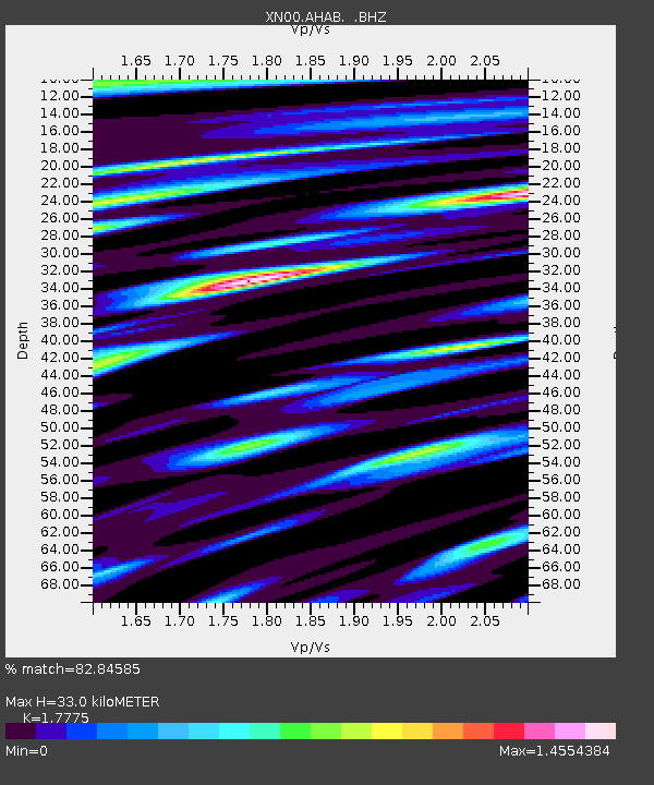
| Estimated Moho Depth: |
33.0 km |
| Estimated Crust Vp/Vs: |
1.78 |
| Assumed Crust Vp: |
6.183 km/s |
| Estimated Crust Vs: |
3.478 km/s |
| Estimated Crust Poisson's Ratio: |
0.27 |
|
| Radial Match: |
82.84585 % |
| Radial Bump: |
400 |
| Transverse Match: |
70.594284 % |
| Transverse Bump: |
400 |
| SOD ConfigId: |
16820 |
| Insert Time: |
2010-03-08 23:15:51.122 +0000 |
| GWidth: |
2.5 |
| Max Bumps: |
400 |
| Tol: |
0.001 |
|

Signal To Noise
| Channel | StoN | STA | LTA |
| XN:AHAB: :BHZ:20020328T05:07:22.925024Z | 2.2721622 | 2.003034E-6 | 8.815542E-7 |
| XN:AHAB: :BHN:20020328T05:07:22.925024Z | 0.89474124 | 1.0836856E-6 | 1.2111719E-6 |
| XN:AHAB: :BHE:20020328T05:07:22.925024Z | 7.549001 | 5.295383E-6 | 7.01468E-7 |
| Arrivals |
| Ps | 4.3 SECOND |
| PpPs | 14 SECOND |
| PsPs/PpSs | 19 SECOND |


