
Station XN AHAB - XN.AHAB
Network: XN00 - RPI-UW Parkfield Calibration Array
Nearby stations (2 deg radius)
| Station | Name | (Lat, Lon) | Start / End | Elevation |
| AHAB | XN.AHAB | (35.98, -120.54) | 2001-06-24 / 2002-10-15 | 760 m |
| Crust2 Type: | S1,continental slope, margin, transition 1 km seds. |
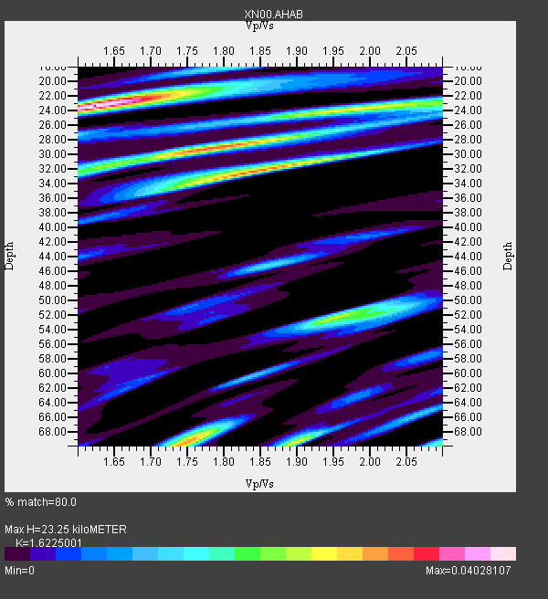
| Thickness Estimate: | 23 km |
| Thickness StdDev: | 18 km |
| Vp/Vs Estimate: | 1.62 |
| Vp/Vs StdDev: | 0.14 |
| Vs Estimate: | 3.811 km/s |
| Poisson's Ratio: | 0.19 |
| Peak Value: | 0.04 |
| Assumed Vp: | 6.183 km/s |
| Ps Weight: | 0.33333334 |
| PpPs Weight: | 0.33333334 |
| PsPs Weight: | 0.33333328 |
| Residual Complexity: | 0.845 |
| Nearby stations H: | 30 km +- 13 km |
| (2.0 deg) Vp/Vs: | 1.71 +- 0.13 |
0 with match > 90% ( 0.0 %) and 3 with match > 80% ( 75.0 %) out of 4.
Download stack as xyz text file.
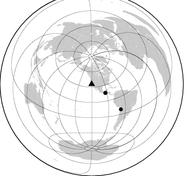
Azimuth Distribution of Events:
Prior Results for this Station
| Study | Thickness | Vp/Vs | Vp | Vs | Poissons Ratio | Extra |
| EARS | 23 km | 1.62 | 6.183 km/s | 3.811 km/s | 0.19 | |
| Crust2.0 | 23 km | 1.81 | 6.183 km/s | 3.422 km/s | 0.28 | S1,continental slope, margin, transition 1 km seds. |
| Global Maxima | 23 km | 1.62 | 6.183 km/s | 3.811 km/s | 0.19 | amp=0.04028107 |
| Local Maxima 1 | 32 km | 1.85 | 6.183 km/s | 3.337 km/s | 0.29 | amp=0.031968575 |
| Local Maxima 2 | 29 km | 1.79 | 6.183 km/s | 3.464 km/s | 0.27 | amp=0.030931644 |
| Local Maxima 3 | 69 km | 1.75 | 6.183 km/s | 3.538 km/s | 0.26 | amp=0.029567914 |
| Local Maxima 4 | 69 km | 1.90 | 6.183 km/s | 3.258 km/s | 0.31 | amp=0.025531651 |
| Predicted Arrivals for vertical incidence (zero ray parameter) | |
| Ps | 2.34 SECOND |
| PpPs | 9.86 SECOND |
| PsPs/PpSs | 12.20 SECOND |
Events Processed for this Station
Download zip of receiver functions as SAC
Plot maxima for each earthquake.
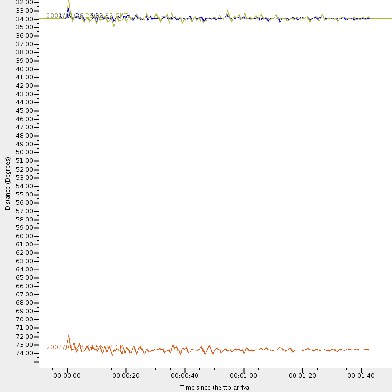
Events Used in the Stack
(3 events)| Radial Match | Distance | Baz | FERegion | Time | Lat/Lon | Depth | Magnitude |
| 83.043816 | 31.8 deg | 122.716 deg | Near Coast Of Chiapas, Mexico | 2002/01/16 23:09:52 GMT | (15.5, -93.1) | 80 km | 5.8 MB, 6.4 MW, 6.4 MW |
| 82.84585 | 75.7 deg | 130.641 deg | Chile-Bolivia Border Region | 2002/03/28 04:56:22 GMT | (-21.7, -68.3) | 125 km | 6.1 MB, 6.5 MW, 6.5 MW |
| 80.418106 | 31.8 deg | 122.589 deg | Near Coast Of Chiapas, Mexico | 2001/11/28 14:32:32 GMT | (15.6, -93.1) | 85 km | 5.7 MB, 6.4 MW, 6.4 MW |
Losers
(1 events)| Radial Match | Distance | Baz | FERegion | Time | Lat/Lon | Depth | Magnitude | Reason |
| 68.256454 | 82.0 deg | 134.458 deg | Catamarca Province, Argentina | 2002/05/28 04:04:22 GMT | (-28.9, -66.8) | 22 km | 6.0 MB, 5.7 MS, 6.0 MW, 5.9 MW |
