You are here: Home > Network List > SP - South Carolina Earth Physics Project Stations List
> Station BLACK Blackville-Hilda High School, Barnwell County, SC USA > Earthquake Result Viewer
BLACK Blackville-Hilda High School, Barnwell County, SC USA - Earthquake Result Viewer
| Earthquake location: |
Near Coast Of Central Chile |
| Earthquake latitude/longitude: |
-30.8/-71.1 |
| Earthquake time(UTC): |
2002/06/18 (169) 13:56:22 GMT |
| Earthquake Depth: |
54 km |
| Earthquake Magnitude: |
6.0 MB, 6.6 MW, 6.4 MW |
| Earthquake Catalog/Contributor: |
WHDF/NEIC |
|
| Network: |
SP South Carolina Earth Physics Project |
| Station: |
BLACK Blackville-Hilda High School, Barnwell County, SC USA |
| Lat/Lon: |
33.36 N/81.26 W |
| Elevation: |
94 m |
|
| Distance: |
64.5 deg |
| Az: |
350.609 deg |
| Baz: |
170.342 deg |
| Ray Param: |
0.05874059 |
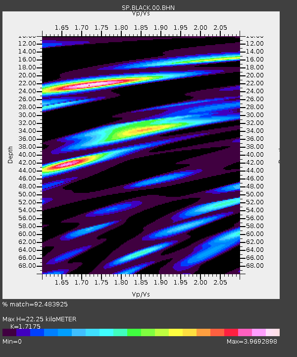
| Estimated Moho Depth: |
22.25 km |
| Estimated Crust Vp/Vs: |
1.72 |
| Assumed Crust Vp: |
6.565 km/s |
| Estimated Crust Vs: |
3.822 km/s |
| Estimated Crust Poisson's Ratio: |
0.24 |
|
| Radial Match: |
92.483925 % |
| Radial Bump: |
400 |
| Transverse Match: |
76.12181 % |
| Transverse Bump: |
400 |
| SOD ConfigId: |
2217 |
| Insert Time: |
2010-02-25 16:35:39.026 +0000 |
| GWidth: |
2.5 |
| Max Bumps: |
400 |
| Tol: |
0.001 |
|

Signal To Noise
| Channel | StoN | STA | LTA |
| SP:BLACK:00:BHN:20020618T14:06:23.470015Z | 4.198927 | 1.276677E-6 | 3.040484E-7 |
| SP:BLACK:00:BHE:20020618T14:06:23.470015Z | 1.2658145 | 3.0492484E-7 | 2.4089218E-7 |
| SP:BLACK:00:BHZ:20020618T14:06:23.470015Z | 4.293133 | 1.3678849E-6 | 3.1862163E-7 |
| Arrivals |
| Ps | 2.5 SECOND |
| PpPs | 8.8 SECOND |
| PsPs/PpSs | 11 SECOND |


