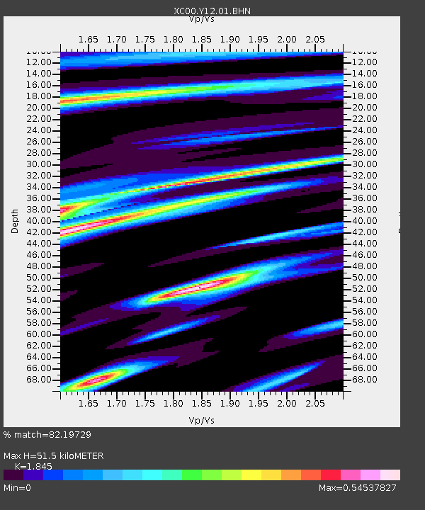
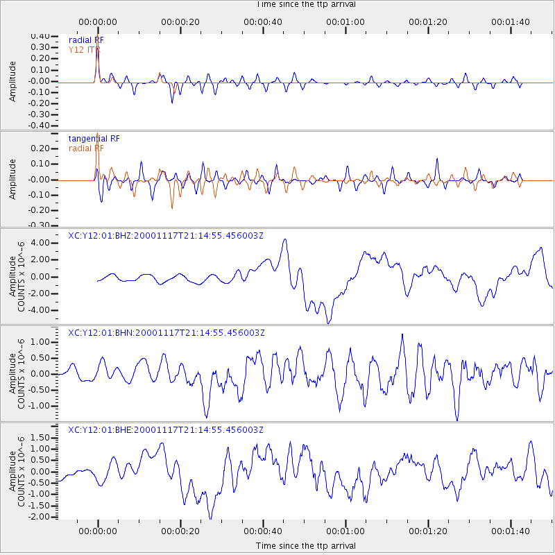
Y12 Y12 - Earthquake Result Viewer

Earthquake location: New Britain Region, P.N.G.
Earthquake latitude/longitude: -5.5/151.8
Earthquake time(UTC): 2000/11/17 (322) 21:01:56 GMT
Earthquake Depth: 33 km
Earthquake Magnitude: 6.2 MB, 8.0 MS, 7.6 MW, 6.9 ME
Earthquake Catalog/Contributor: WHDF/NEIC
Network: XC Yellowstone Intermountain Seismic Array
Station: Y12 Y12
Lat/Lon: 45.60 N/113.11 W
Elevation: 2051 m
Distance: 97.5 deg
Az: 44.851 deg
Baz: 269.786 deg
Ray Param: 0.040189225
Estimated Moho Depth: 51.5 km
Estimated Crust Vp/Vs: 1.85
Assumed Crust Vp: 6.577 km/s
Estimated Crust Vs: 3.565 km/s
Estimated Crust Poisson's Ratio: 0.29
Radial Match: 82.19729 %
Radial Bump: 355
Transverse Match: 65.37004 %
Transverse Bump: 400
SOD ConfigId: 16820
Insert Time: 2010-02-26 14:59:44.819 +0000
GWidth: 2.5
Max Bumps: 400
Tol: 0.001

Signal To Noise

ChannelStoNSTALTA
XC:Y12:01:BHN:20001117T21:14:55.456003Z1.1530983.101576E-72.6897766E-7
XC:Y12:01:BHE:20001117T21:14:55.456003Z1.58922664.5061725E-72.8354498E-7
XC:Y12:01:BHZ:20001117T21:14:55.456003Z1.39141835.392937E-73.875856E-7
Arrivals
Ps6.7 SECOND
PpPs22 SECOND
PsPs/PpSs29 SECOND