You are here: Home > Network List > XC00 - Yellowstone Intermountain Seismic Array Stations List
> Station Y38 Y38 > Earthquake Result Viewer
Y38 Y38 - Earthquake Result Viewer
| Earthquake location: |
Tonga Islands |
| Earthquake latitude/longitude: |
-15.9/-173.7 |
| Earthquake time(UTC): |
2000/09/11 (255) 17:17:53 GMT |
| Earthquake Depth: |
115 km |
| Earthquake Magnitude: |
6.0 MB, 6.3 MW, 6.3 MW |
| Earthquake Catalog/Contributor: |
WHDF/NEIC |
|
| Network: |
XC Yellowstone Intermountain Seismic Array |
| Station: |
Y38 Y38 |
| Lat/Lon: |
45.90 N/111.61 W |
| Elevation: |
1298 m |
|
| Distance: |
83.1 deg |
| Az: |
38.431 deg |
| Baz: |
238.93 deg |
| Ray Param: |
0.046165265 |
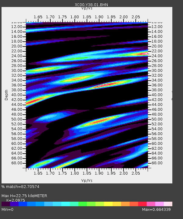
| Estimated Moho Depth: |
22.75 km |
| Estimated Crust Vp/Vs: |
2.10 |
| Assumed Crust Vp: |
6.35 km/s |
| Estimated Crust Vs: |
3.027 km/s |
| Estimated Crust Poisson's Ratio: |
0.35 |
|
| Radial Match: |
82.70574 % |
| Radial Bump: |
400 |
| Transverse Match: |
86.44037 % |
| Transverse Bump: |
400 |
| SOD ConfigId: |
16820 |
| Insert Time: |
2010-02-26 14:59:54.335 +0000 |
| GWidth: |
2.5 |
| Max Bumps: |
400 |
| Tol: |
0.001 |
|

Signal To Noise
| Channel | StoN | STA | LTA |
| XC:Y38:01:BHN:20000911T17:29:35.248999Z | 1.4273585 | 5.0951405E-7 | 3.569629E-7 |
| XC:Y38:01:BHE:20000911T17:29:35.248999Z | 1.6033322 | 4.2686497E-7 | 2.6623616E-7 |
| XC:Y38:01:BHZ:20000911T17:29:35.248999Z | 5.3268027 | 1.6083208E-6 | 3.0192984E-7 |
| Arrivals |
| Ps | 4.0 SECOND |
| PpPs | 11 SECOND |
| PsPs/PpSs | 15 SECOND |


