
Station XC Y38 - Y38
Network: XC00 - Yellowstone Intermountain Seismic Array
Nearby stations (2 deg radius)
| Station | Name | (Lat, Lon) | Start / End | Elevation |
| Y38 | Y38 | (45.90, -111.61) | 2000-07-09 / 2001-12-31 | 1298 m |
| Crust2 Type: | P6,orogen/43km, Orogen, 0.5 km seds. |
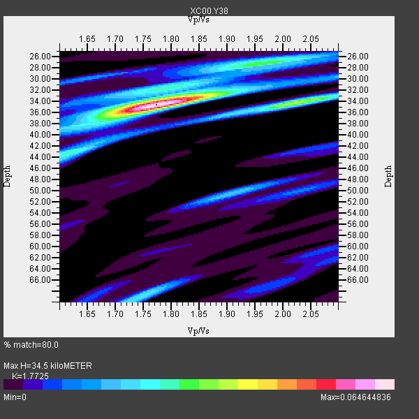
| Thickness Estimate: | 34 km |
| Thickness StdDev: | 5.5 km |
| Vp/Vs Estimate: | 1.77 |
| Vp/Vs StdDev: | 0.05 |
| Vs Estimate: | 3.583 km/s |
| Poisson's Ratio: | 0.27 |
| Peak Value: | 0.06 |
| Assumed Vp: | 6.35 km/s |
| Ps Weight: | 0.33333334 |
| PpPs Weight: | 0.33333334 |
| PsPs Weight: | 0.33333328 |
| Residual Complexity: | 0.570 |
| Nearby stations H: | +- |
| (2.0 deg) Vp/Vs: | +- |
1 with match > 90% ( 20.0 %) and 4 with match > 80% ( 80.0 %) out of 5.
Download stack as xyz text file.
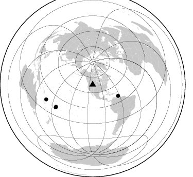
Azimuth Distribution of Events:
Prior Results for this Station
| Study | Thickness | Vp/Vs | Vp | Vs | Poissons Ratio | Extra |
| EARS | 34 km | 1.77 | 6.35 km/s | 3.583 km/s | 0.27 | |
| Crust2.0 | 43 km | 1.76 | 6.35 km/s | 3.609 km/s | 0.26 | P6,orogen/43km, Orogen, 0.5 km seds. |
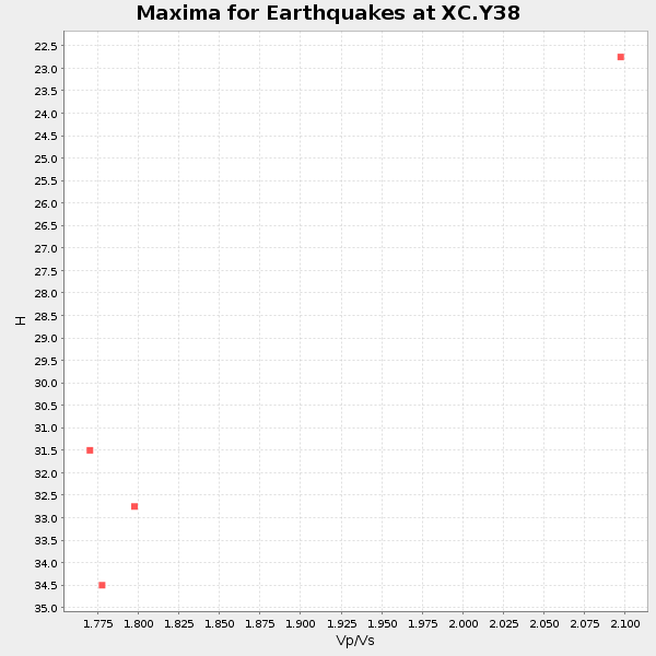
| Global Maxima | 34 km | 1.77 | 6.35 km/s | 3.583 km/s | 0.27 | amp=0.064644836 |
| Local Maxima 1 | 34 km | 2.02 | 6.35 km/s | 3.147 km/s | 0.34 | amp=0.036929127 |
| Local Maxima 2 | 27 km | 1.96 | 6.35 km/s | 3.244 km/s | 0.32 | amp=0.029420145 |
| Local Maxima 3 | 69 km | 1.75 | 6.35 km/s | 3.634 km/s | 0.26 | amp=0.022634868 |
| Local Maxima 4 | 50 km | 1.91 | 6.35 km/s | 3.32 km/s | 0.31 | amp=0.01863786 |
| Predicted Arrivals for vertical incidence (zero ray parameter) | |
| Ps | 4.20 SECOND |
| PpPs | 15.06 SECOND |
| PsPs/PpSs | 19.26 SECOND |
Events Processed for this Station
Download zip of receiver functions as SAC
Plot maxima for each earthquake.
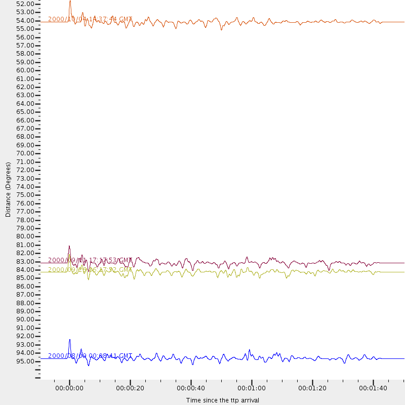
Events Used in the Stack
(4 events)| Radial Match | Distance | Baz | FERegion | Time | Lat/Lon | Depth | Magnitude |
| 92.34223 | 54.1 deg | 113.776 deg | Windward Islands | 2000/10/04 14:37:44 GMT | (11.1, -62.6) | 110 km | 5.6 MB, 5.4 MS, 6.1 MW, 5.9 MD |
| 88.48928 | 84.3 deg | 238.299 deg | Tonga Islands | 2000/09/26 06:17:52 GMT | (-17.2, -173.9) | 56 km | 6.1 MB, 6.1 MS, 6.4 MW, 6.1 ME |
| 86.66272 | 94.6 deg | 252.326 deg | Vanuatu Islands | 2000/08/09 00:08:41 GMT | (-15.7, 168.0) | 33 km | 6.3 MB, 6.0 MS, 6.4 MW, 6.3 MW |
| 82.70574 | 83.1 deg | 238.93 deg | Tonga Islands | 2000/09/11 17:17:53 GMT | (-15.9, -173.7) | 115 km | 6.0 MB, 6.3 MW, 6.3 MW |
Losers
(1 events)| Radial Match | Distance | Baz | FERegion | Time | Lat/Lon | Depth | Magnitude | Reason |
| 82.132286 | 95.1 deg | 253.265 deg | Vanuatu Islands | 2000/10/04 16:58:44 GMT | (-15.4, 166.9) | 23 km | 6.1 MB, 6.9 MS, 6.8 MW, 6.5 ME |
