You are here: Home > Network List > XN00 - RPI-UW Parkfield Calibration Array Stations List
> Station HIDE XN.HIDE > Earthquake Result Viewer
HIDE XN.HIDE - Earthquake Result Viewer
| Earthquake location: |
Chile-Bolivia Border Region |
| Earthquake latitude/longitude: |
-21.7/-68.3 |
| Earthquake time(UTC): |
2002/03/28 (087) 04:56:22 GMT |
| Earthquake Depth: |
125 km |
| Earthquake Magnitude: |
6.1 MB, 6.5 MW, 6.5 MW |
| Earthquake Catalog/Contributor: |
WHDF/NEIC |
|
| Network: |
XN RPI-UW Parkfield Calibration Array |
| Station: |
HIDE XN.HIDE |
| Lat/Lon: |
35.97 N/120.55 W |
| Elevation: |
667 m |
|
| Distance: |
75.7 deg |
| Az: |
318.563 deg |
| Baz: |
130.636 deg |
| Ray Param: |
0.051214304 |
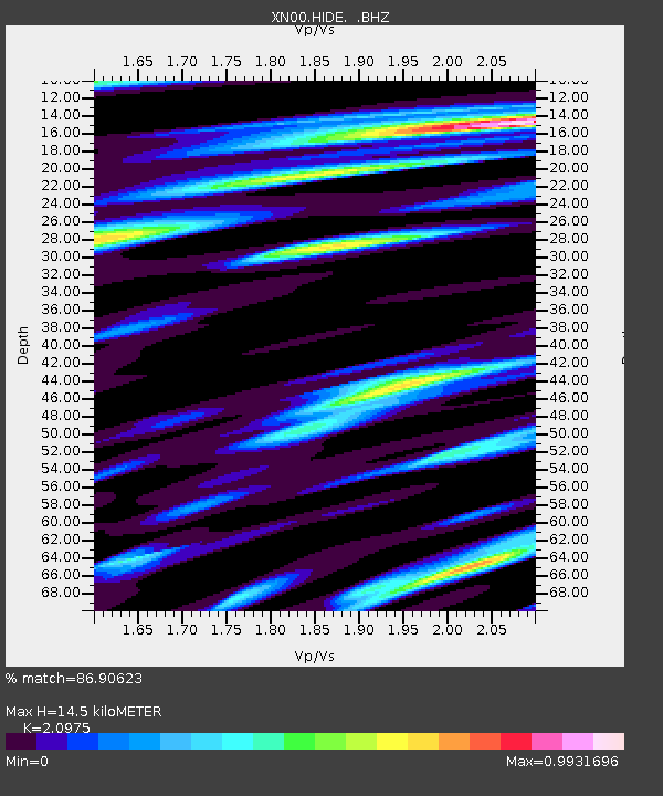
| Estimated Moho Depth: |
14.5 km |
| Estimated Crust Vp/Vs: |
2.10 |
| Assumed Crust Vp: |
6.183 km/s |
| Estimated Crust Vs: |
2.948 km/s |
| Estimated Crust Poisson's Ratio: |
0.35 |
|
| Radial Match: |
86.90623 % |
| Radial Bump: |
400 |
| Transverse Match: |
78.79688 % |
| Transverse Bump: |
400 |
| SOD ConfigId: |
16820 |
| Insert Time: |
2010-03-08 23:20:43.341 +0000 |
| GWidth: |
2.5 |
| Max Bumps: |
400 |
| Tol: |
0.001 |
|

Signal To Noise
| Channel | StoN | STA | LTA |
| XN:HIDE: :BHZ:20020328T05:07:22.900Z | 2.806923 | 1.9938575E-6 | 7.1033566E-7 |
| XN:HIDE: :BHN:20020328T05:07:22.900Z | 0.7895921 | 8.4553216E-7 | 1.0708468E-6 |
| XN:HIDE: :BHE:20020328T05:07:22.900Z | 7.8288865 | 5.354303E-6 | 6.8391626E-7 |
| Arrivals |
| Ps | 2.6 SECOND |
| PpPs | 7.1 SECOND |
| PsPs/PpSs | 9.7 SECOND |


