You are here: Home > Network List > XN00 - RPI-UW Parkfield Calibration Array Stations List
> Station HIDE XN.HIDE > Earthquake Result Viewer
HIDE XN.HIDE - Earthquake Result Viewer
| Earthquake location: |
Near Coast Of Chiapas, Mexico |
| Earthquake latitude/longitude: |
15.5/-93.1 |
| Earthquake time(UTC): |
2002/01/16 (016) 23:09:52 GMT |
| Earthquake Depth: |
80 km |
| Earthquake Magnitude: |
5.8 MB, 6.4 MW, 6.4 MW |
| Earthquake Catalog/Contributor: |
WHDF/NEIC |
|
| Network: |
XN RPI-UW Parkfield Calibration Array |
| Station: |
HIDE XN.HIDE |
| Lat/Lon: |
35.97 N/120.55 W |
| Elevation: |
667 m |
|
| Distance: |
31.8 deg |
| Az: |
314.917 deg |
| Baz: |
122.696 deg |
| Ray Param: |
0.07870881 |
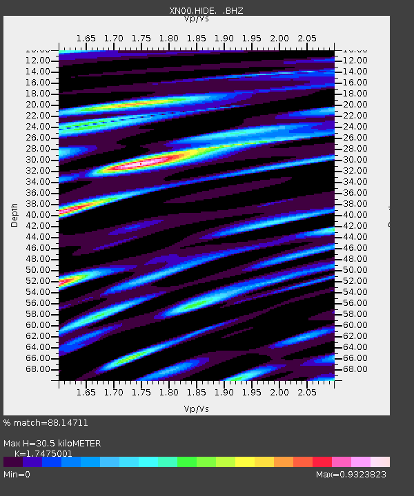
| Estimated Moho Depth: |
30.5 km |
| Estimated Crust Vp/Vs: |
1.75 |
| Assumed Crust Vp: |
6.183 km/s |
| Estimated Crust Vs: |
3.538 km/s |
| Estimated Crust Poisson's Ratio: |
0.26 |
|
| Radial Match: |
88.14711 % |
| Radial Bump: |
400 |
| Transverse Match: |
78.7528 % |
| Transverse Bump: |
400 |
| SOD ConfigId: |
4714 |
| Insert Time: |
2010-03-08 23:20:44.463 +0000 |
| GWidth: |
2.5 |
| Max Bumps: |
400 |
| Tol: |
0.001 |
|

Signal To Noise
| Channel | StoN | STA | LTA |
| XN:HIDE: :BHZ:20020116T23:15:39.050001Z | 1.6078897 | 1.1594032E-6 | 7.210714E-7 |
| XN:HIDE: :BHN:20020116T23:15:39.050001Z | 1.8973827 | 1.3576001E-6 | 7.15512E-7 |
| XN:HIDE: :BHE:20020116T23:15:39.050001Z | 5.2694654 | 2.8471486E-6 | 5.4031074E-7 |
| Arrivals |
| Ps | 4.0 SECOND |
| PpPs | 13 SECOND |
| PsPs/PpSs | 17 SECOND |


